METAR & TAF SD2
SD2 does not publish a METAR.
Showing the nearest reporting station: KCNB (MYERS FLD) · 9.0 NM away. Conditions at SD2 may differ.
METAR · KCNB
Observed 08:15Z
KCNB 140815Z AUTO 32007KT 10SM OVC055 15/09 A3005 RMK AO2 T01460087
- Wind
- 320° @ 7 kt
- Visibility
- 10 SM
- Temp / Dew
- 15°C / 9°C
- Altimeter
- 30.05 inHg
- Clouds
- OVC
- Density alt
- 1,934 ft
- Ceiling
- 5,500 ft AGL
- Rules
- VFR
Airport info & contacts
Manager on record, flight service, ARTCC, attendance schedule and pattern altitude — published by the FAA and refreshed every 28 days.
Location
- From city
- 5 NM S
- VFR sectional
- TWIN CITIES
- ARTCC
- ZMP · MINNEAPOLIS
- NOTAM facility
- HON (NOTAM-D)
Airport manager
- Name
- JAMES EKHOLM
- Phone
- 561-702-5870
- Address
- 2382 LAKE COCHRANE DRIVE EAST, GARY SD 57237
Flight service · Hours
- FSS HON
- HURON1-800-WX-BRIEF
Frequencies
Tap any row to copy the frequency to your clipboard.
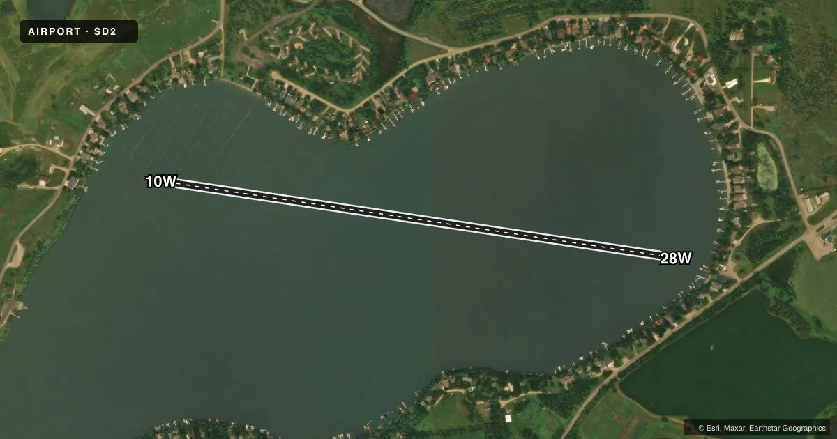
Runways & pattern
Full pagePattern entry · RWY 28W
LEFT TRAFFICAirport sketch
Runways drawn to scale from FAA survey coordinates, rendered over satellite imagery. Not for navigation.
Approaches & charts
Services on the field
Fuel grades, oxygen, maintenance, ramp storage and lighting — as declared to the FAA by the airport operator.
Fuel & services
- Fuel
- 100LLUL91
Ramp & ground
- Transient storage
- Not published
- Wind indicator
- Yes
Fuel & FBOs
Cheapest 100LL and Jet A on the field and nearby. Always confirm with the FBO before taxi.
Airport notes
Surface conditions, obstructions, local procedures, lighting outages and other notes published with each FAA cycle.
General notes
- FOR CD CTC MINNEAPOLIS ARTCC AT 651-463-5588.
- ARPT CLSD 1 DEC T0 1 MAY.
Fuel notes
- 100LLCALL 507-829-9073.
- UL91CALL 507-829-9073.
VFR map & nearby airports
VFR sectional. Tap any ICAO chip to open that airport.
Key facts · SD2
Answer card- ICAO
- SD2
- Name
- LAKE COCHRANE
- Location
- GARY, SOUTH DAKOTA
- Elevation
- 1,690 ft MSL
- Traffic pattern altitude
- 2,690 ft MSL (1,000 AGL)
- Control tower
- Non-towered (use CTAF)
- Total runways
- 1
- Longest runway
- 10W/28W · 3,920 ft
- Published ILS approaches
- 0
- Published frequencies
- 1
- Magnetic variation
- –
- Current flight rules
- VFR
- Current wind
- 320° at 7 kt
- Favored runway now
- RWY 28W
Lake Cochrane (SD2) is in Gary, South Dakota. Field elevation is 1,690 ft MSL. The airport has one runway. It is a 3,920 ft water runway, designated 10W/28W. No control tower is published here. CTAF is 122.9. No ILS approaches are published. Pattern altitude is not published, so verify the current Chart Supplement before you go. The airport is closed from December 1 to May 1, so plan around that seasonal closure.
There are no on-field FBOs listed. Published remarks say to call 507-829-9073 for UL91 or 100LL fuel. Clearance delivery is handled through Minneapolis ARTCC at 651-463-5588. For a first-time arrival, the big items are the water surface. The seasonal closure matters too. Check the current Chart Supplement for any other local notes before departure. Magnetic runway headings are published as 98.4894871106448 degrees for 10W and 278.489487110645 degrees for 28W.