METAR & TAF 1D1
Current METAR
Observed 21:35Z
K1D1 272135Z AUTO 35007KT 10SM CLR 31/24 A2981 RMK AO2
- Wind
- 350° @ 7 kt
- Visibility
- 10 SM
- Temp / Dew
- 31°C / 24°C
- Altimeter
- 29.81 inHg
- Clouds
- CLR
- Density alt
- 3,442 ft
- Ceiling
- Unlimited
- Rules
- VFR
Airport info & contacts
Manager on record, flight service, ARTCC, attendance schedule and pattern altitude — published by the FAA and refreshed every 28 days.
Location
- From city
- 3 NM E
- VFR sectional
- TWIN CITIES
- ARTCC
- ZMP · MINNEAPOLIS
- NOTAM facility
- HON (NOTAM-D)
Airport manager
- Name
- STEVE PENDERGRASS
- Phone
- 605-432-9575
- Address
- 1001 E. 4TH AVE., #301, MILBANK SD 57252-6034
Flight service · Hours
- FSS HON
- HURON1-800-WX-BRIEF
- Attendance
- MON-FRI · 0900-1500
Frequencies
Tap any row to copy the frequency to your clipboard.
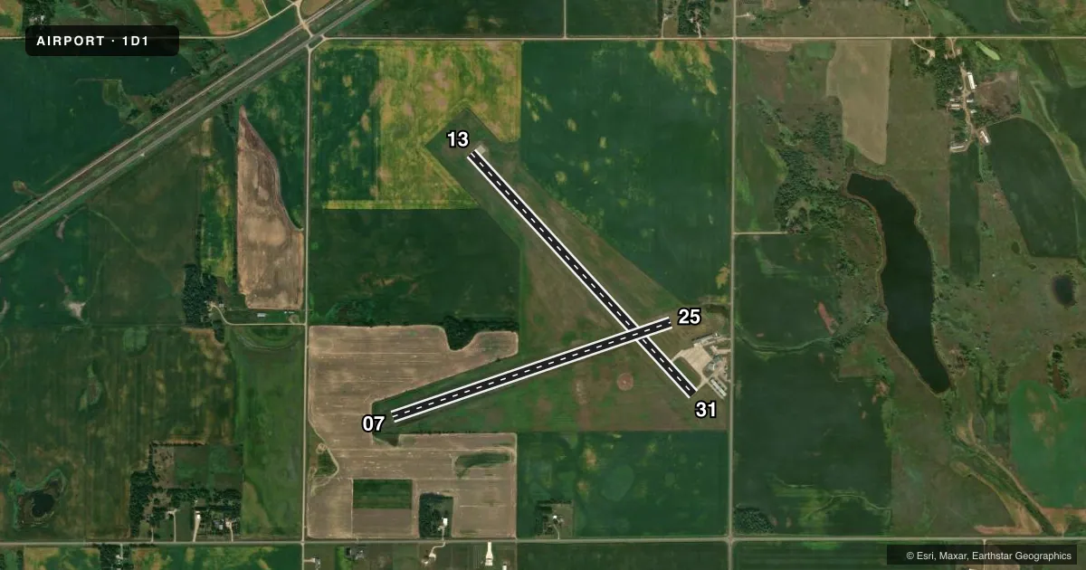
Runways & pattern
Full pagePattern entry · RWY 31
LEFT TRAFFIC| Runway | Heading (°M) | Length | Surface | Traffic |
|---|---|---|---|---|
| 13/31Favored | 132° / 312° | 4,000 ft | CONC | Standard L |
| 07/25 | 66° / 246° | 3,586 ft | TURF | Standard L |
Runway end performance
| End | TORA | TODA | ASDA | LDA | VGSI | Approach lights | Obstruction |
|---|---|---|---|---|---|---|---|
| 13 | — | — | — | — | PAPI 2-box left(3°) | — | — |
| 31 | — | — | — | — | PAPI 2-box left(3°) | — | 15', road, 525' from thr, 0' R of cntrln, slope 21 |
| 07 | — | — | — | — | — | — | 5', fence, 200' from thr, 0' R of cntrln, slope 40 |
Declared distances in feet. TORA = takeoff run available, TODA = takeoff distance, ASDA = accelerate-stop, LDA = landing distance.
Airport sketch
Runways drawn to scale from FAA survey coordinates, rendered over satellite imagery. Not for navigation.
Approaches & charts
Services on the field
Fuel grades, oxygen, maintenance, ramp storage and lighting — as declared to the FAA by the airport operator.
Fuel & services
- Fuel
- 100LL
- Oxygen (bottled)
- Not available
- Oxygen (bulk)
- Not available
- Airframe repair
- Minor
- Power plant repair
- Minor
- Other services
- AGRI,INSTR
Ramp & ground
- Transient storage
- Tie-down
- Hangar
- Landing fee
- No fee published
- Customs
- Not available
- Lighting schedule
- SEE RMK
- Beacon schedule
- SS-SR
- Beacon
- White / Green (civil land)(WG)
- Wind indicator
- Lighted
- Segmented circle
- No
Fuel & FBOs
Cheapest 100LL and Jet A on the field and nearby. Always confirm with the FBO before taxi.
Airport notes
Surface conditions, obstructions, local procedures, lighting outages and other notes published with each FAA cycle.
General notes
- RY 31 +4' FENCE 600' FM THR & 10' R FM CNTRLN & 350' FM THR & 250' R FM CNTRLN.
- RY 13 +4' FENCE 450' FM THR.
- ULTRALIGHT ACT ON AND INVOF ARPT.
- WATERFOWL ON AND INVOF ARPT.
- FOR CD CTC MINNEAPOLIS ARTCC AT 651-463-5588.
Lighting notes
- ACTVT MIRL RY 13/31 & PAPI RY 31 - CTAF.
Fuel notes
- 100LLFUEL AVBL 24 HRS WITH CREDIT CARD.
Runway surface & condition
- 07/25RY 07/25 CLSD WINTER MONTHS.
Approach & departure obstructions
- 07RWY 07/25 MKD WITH WHITE & BLACK PLASTIC MKR CONES.
Other notes
- AUTOMATED UNICOM.
- 1UNATNDD HOLS.
VFR map & nearby airports
VFR sectional. Tap any ICAO chip to open that airport.
Key facts · 1D1
Answer card- ICAO
- 1D1
- Name
- MILBANK MUNI
- Location
- MILBANK, SOUTH DAKOTA
- Elevation
- 1,117.8 ft MSL
- Traffic pattern altitude
- 2,117.8 ft MSL (1,000 AGL)
- Control tower
- Non-towered (use CTAF)
- Total runways
- 2
- Longest runway
- 13/31 · 4,000 ft
- Published ILS approaches
- 0
- Published frequencies
- 2
- Magnetic variation
- 5°
- Current flight rules
- VFR
- Current wind
- 350° at 7 kt
- Favored runway now
- RWY 31
Milbank Muni sits in Milbank, South Dakota. Field elevation is 1,117.8 ft MSL. The airport has two runways. The longest is runway 13/31 at 4,000 ft concrete. Runway 07/25 is 3,586 ft turf. There is no control tower. CTAF and UNICOM are both 122.8. No ILS approaches are published.
Pattern altitude is not published. Use the standard 1,000 ft AGL pattern for light piston operations unless current airport guidance says otherwise. The field has automated UNICOM. 100LL is available 24 hours with credit card at Milbank Municipal Airport. If you need clearance delivery, Minneapolis ARTCC is listed at 651-463-5588.
A first-time pilot should pay attention to the runway notes. Runway 07/25 is closed during winter months. Medium intensity runway lights are on runway 13/31. A PAPI is available on runway 31 and is activated by CTAF. Waterfowl and ultralight activity are both reported on and near the airport. There is also a fence near runway 13. Runway 31 has fences close to the threshold and right of centerline. Check the current FAA Chart Supplement before you go for any changes or local operating notes.