METAR & TAF KAQP
Current METAR
Observed 01:35Z
KAQP 270135Z AUTO 17005KT 10SM CLR 31/27 A2972 RMK AO2 T03080274
- Wind
- 170° @ 5 kt
- Visibility
- 10 SM
- Temp / Dew
- 31°C / 27°C
- Altimeter
- 29.72 inHg
- Clouds
- CLR
- Density alt
- 3,434 ft
- Ceiling
- Unlimited
- Rules
- VFR
Airport info & contacts
Manager on record, flight service, ARTCC, attendance schedule and pattern altitude — published by the FAA and refreshed every 28 days.
Location
- From city
- 2 NM NE
- VFR sectional
- TWIN CITIES
- ARTCC
- ZMP · MINNEAPOLIS
- NOTAM facility
- AQP (NOTAM-D)
Airport manager
- Name
- GREG RUETHER
- Phone
- (320) 413-0089
- Address
- 149 S MUNSTERMAN, APPLETON MN 56208
Flight service · Hours
- FSS PNM
- PRINCETON1-800-WX-BRIEF
- Attendance
- Unattended
Frequencies
Tap any row to copy the frequency to your clipboard.
Runways & pattern
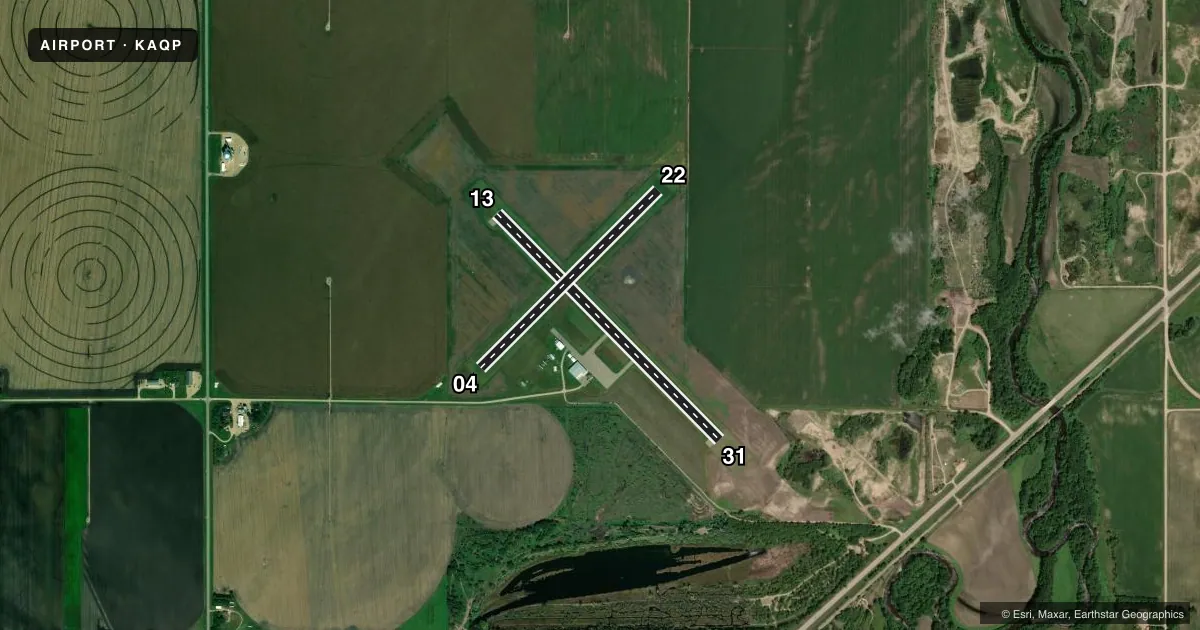
Full pagePattern entry · RWY 13
LEFT TRAFFICAirport sketch
Runways drawn to scale from FAA survey coordinates, rendered over satellite imagery. Not for navigation.
Approaches & charts
Services on the field
Fuel grades, oxygen, maintenance, ramp storage and lighting — as declared to the FAA by the airport operator.
Fuel & services
- Fuel
- Not available
- Oxygen (bottled)
- Not available
- Oxygen (bulk)
- Not available
- Airframe repair
- Not available
- Power plant repair
- Not available
- Other services
- SALES
Ramp & ground
- Transient storage
- Tie-down
- Landing fee
- No fee published
- Customs
- Not available
- Lighting schedule
- SEE RMK
- Beacon schedule
- SS-SR
- Beacon
- White / Green (civil land)(WG)
- Wind indicator
- Lighted
- Segmented circle
- No
Fuel & FBOs
Cheapest 100LL and Jet A on the field and nearby. Always confirm with the FBO before taxi.
Airport notes
Surface conditions, obstructions, local procedures, lighting outages and other notes published with each FAA cycle.
General notes
- FOR CD CTC MINNEAPOLIS ARTCC AT 651-463-5588.
Lighting notes
- ACTVT MIRL RY 13/31 - CTAF.
Runway surface & condition
- 04/22CLOSED WINTER MONTHS.
- 13/31RY 13 VISUAL LIGHTING ON INSTRUMENT RY.
Approach & departure obstructions
- 04MKD WITH YELLOW CONES.
- 22MKD WITH YELLOW CONES.
Other notes
- EXISTED PRIOR TO 1959.
- 13/31CRACKING.
VFR map & nearby airports
VFR sectional. Tap any ICAO chip to open that airport.
Key facts · KAQP
Answer card- ICAO
- KAQP
- Name
- APPLETON MUNI
- Location
- APPLETON, MINNESOTA
- Elevation
- 1,021 ft MSL
- Traffic pattern altitude
- 2,021 ft MSL (1,000 AGL)
- Control tower
- Non-towered (use CTAF)
- Total runways
- 2
- Longest runway
- 13/31 · 3,500 ft
- Published ILS approaches
- 0
- Published frequencies
- 1
- Magnetic variation
- 5°
- Current flight rules
- VFR
- Current wind
- 170° at 5 kt
- Favored runway now
- RWY 13
Appleton Muni sits in Appleton, Minnesota. The field elevation is 1,021 ft MSL. It has two runways. The longest is runway 13/31 at 3,500 ft. Runway 04/22 is 2,770 ft of turf. This is an untowered field. CTAF is 122.9.
No ILS approaches are published here. Pattern altitude is not published, so use the standard 1,000 ft AGL for light piston operations unless the current Chart Supplement says otherwise. Runway 13/31 has medium intensity lighting that is activated by CTAF. The published remarks also note cracking on 13/31. Runway 22 is marked with yellow cones. Runway 04 is marked with yellow cones. Runway 04/22 is closed during winter months.
There are no on-field FBOs listed in the facts, so plan to verify services before you go. For clearance delivery, contact Minneapolis ARTCC at 651-463-5588. The airport is in a rural Minnesota setting with no tower. That means self-announce discipline matters. Check the current Chart Supplement for any local procedures before flying in, especially if you plan to use the turf runway or arrive in winter conditions.