METAR & TAF KBBB
Current METAR
Observed 23:00Z
KBBB 272300Z AUTO 34009G14KT 8SM CLR 30/23 A2978 RMK AO2
- Wind
- 340° @ 9G14 kt
- Visibility
- 8 SM
- Temp / Dew
- 30°C / 23°C
- Altimeter
- 29.78 inHg
- Clouds
- CLR
- Density alt
- 3,262 ft
- Ceiling
- Unlimited
- Rules
- VFR
Airport info & contacts
Manager on record, flight service, ARTCC, attendance schedule and pattern altitude — published by the FAA and refreshed every 28 days.
Location
- From city
- 2 NM W
- VFR sectional
- TWIN CITIES
- ARTCC
- ZMP · MINNEAPOLIS
- NOTAM facility
- BBB (NOTAM-D)
Airport manager
- Name
- MATT SKARET
- Phone
- 320-843-4775
- Address
- 1410 KANSAS AVE, BENSON MN 56215
Flight service · Hours
- FSS PNM
- PRINCETON1-800-WX-BRIEF
- Attendance
- Unattended
Frequencies
Tap any row to copy the frequency to your clipboard.
Runways & pattern
Full pagePattern entry · RWY 32
LEFT TRAFFICRunway end performance
| End | TORA | TODA | ASDA | LDA | VGSI | Approach lights | Obstruction |
|---|---|---|---|---|---|---|---|
| 14 | — | — | — | — | PAPI 4-box left(3°) | — | 7', brush, 334' from thr, 139' R of cntrln, slope 19 |
| 32 | — | — | — | — | PAPI 4-box left(3°) | — | 33', trees, 773' from thr, 221' R of cntrln, slope 17 |
Declared distances in feet. TORA = takeoff run available, TODA = takeoff distance, ASDA = accelerate-stop, LDA = landing distance.
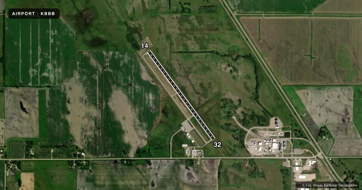
Airport sketch
Runways drawn to scale from FAA survey coordinates, rendered over satellite imagery. Not for navigation.
Approaches & charts
Services on the field
Fuel grades, oxygen, maintenance, ramp storage and lighting — as declared to the FAA by the airport operator.
Fuel & services
- Fuel
- 100LLA
- Oxygen (bottled)
- Not available
- Oxygen (bulk)
- Not available
- Airframe repair
- Minor
- Power plant repair
- Minor
- Other services
- AGRI,SALES
Ramp & ground
- Transient storage
- Tie-down
- Hangar
- Landing fee
- No fee published
- Customs
- Not available
- Lighting schedule
- SEE RMK
- Beacon schedule
- SS-SR
- Beacon
- White / Green (civil land)(WG)
- Wind indicator
- Lighted
- Segmented circle
- Yes
Fuel & FBOs
Cheapest 100LL and Jet A on the field and nearby. Always confirm with the FBO before taxi.
Airport notes
Surface conditions, obstructions, local procedures, lighting outages and other notes published with each FAA cycle.
General notes
- CATEGORY 'C' & 'D' ACFT OPNS PROHIBITED.
- FOR CD CTC MINNEAPOLIS ARTCC AT 651-463-5588.
Lighting notes
- MIRL RY 14/32 PRESET LOW INTST TO INCR INTST AND ACTVT REIL RY 14/32; PAPI RY 14//32; MIRL RY 14/32 - CTAF.
Fuel notes
- 100LLSELF SERVE FUEL AVAIL 24 HRS WITH CREDIT CARD.
Approach & departure obstructions
- 14RY 14 PAPI UNUSEABLE BYD 2 NM.
VFR map & nearby airports
VFR sectional. Tap any ICAO chip to open that airport.
Key facts · KBBB
Answer card- ICAO
- KBBB
- Name
- BENSON MUNI
- Location
- BENSON, MINNESOTA
- Elevation
- 1,039.3 ft MSL
- Traffic pattern altitude
- 2,039.3 ft MSL (1,000 AGL)
- Control tower
- Non-towered (use CTAF)
- Total runways
- 1
- Longest runway
- 14/32 · 4,000 ft
- Published ILS approaches
- 0
- Published frequencies
- 2
- Magnetic variation
- 5°
- Current flight rules
- VFR
- Current wind
- 340° at 9 kt
- Favored runway now
- RWY 32
Benson Muni sits in Benson, Minnesota. The field elevation is 1,039.3 ft MSL. It has one runway, 14/32, which is 4,000 ft long. There is no control tower. CTAF and UNICOM are both 122.8. No ILS approaches are published here.
Pattern altitude is not published. Use the standard 1,000 ft AGL unless the current Chart Supplement says otherwise. That puts the light piston pattern near 2,039.3 ft MSL. The runway has medium intensity lighting. It starts at low intensity. Use CTAF to increase intensity and to activate the runway end identifier lights. PAPI is available on runway 14/32. The published remarks also say runway 14 PAPI is unusable beyond 2 NM.
Benson Municipal Airport is the on-field FBO. It carries 100LL and Jet A Prist. Self-serve fuel is available 24 hours with a credit card. Category C and D aircraft operations are prohibited, so larger aircraft should verify suitability before planning in. For clearance delivery, contact Minneapolis ARTCC at 651-463-5588. For any current procedure changes, check the current FAA Chart Supplement before departure.