METAR & TAF KMHE
Current METAR
Observed 16:53Z
KMHE 271653Z AUTO 04006KT 10SM CLR 33/16 A2986 RMK AO2 SLP097 T03280161
- Wind
- 040° @ 6 kt
- Visibility
- 10 SM
- Temp / Dew
- 33°C / 16°C
- Altimeter
- 29.86 inHg
- Clouds
- CLR
- Density alt
- 3,852 ft
- Ceiling
- Unlimited
- Rules
- VFR
Airport info & contacts
Manager on record, flight service, ARTCC, attendance schedule and pattern altitude — published by the FAA and refreshed every 28 days.
Location
- From city
- 3 NM N
- VFR sectional
- OMAHA
- ARTCC
- ZMP · MINNEAPOLIS
- NOTAM facility
- MHE (NOTAM-D)
Airport manager
- Name
- DAN LONDON
- Phone
- 605-999-7208
- Address
- 621 WEST 5TH, MITCHELL SD 57301
Flight service · Hours
- FSS HON
- HURON1-800-WX-BRIEF
- Attendance
- 0800-1800
Frequencies
Tap any row to copy the frequency to your clipboard.
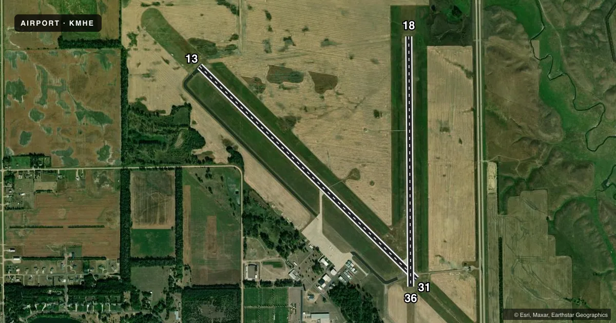
Runways & pattern
Full pagePattern entry · RWY 36
LEFT TRAFFIC| Runway | Heading (°M) | Length | Surface | Traffic |
|---|---|---|---|---|
| 13/31 | 130° / 310° | 6,701 ft | ASPH | Standard L |
| 18/36Favored | 176° / 356° | 5,513 ft | ASPH | Standard L |
Runway end performance
| End | TORA | TODA | ASDA | LDA | VGSI | Approach lights | Obstruction |
|---|---|---|---|---|---|---|---|
| 13 | — | — | — | — | PAPI 4-box left(3°) | — | — |
| 31 | — | — | — | — | PAPI 4-box left(3°) | MALSR | — |
| 18 | — | — | — | — | PAPI 4-box left(3°) | — | — |
| 36 | — | — | — | — | PAPI 4-box left(3°) | — | — |
Declared distances in feet. TORA = takeoff run available, TODA = takeoff distance, ASDA = accelerate-stop, LDA = landing distance.
Airport sketch
Runways drawn to scale from FAA survey coordinates, rendered over satellite imagery. Not for navigation.
Approaches & charts
ILS · 1
Services on the field
Fuel grades, oxygen, maintenance, ramp storage and lighting — as declared to the FAA by the airport operator.
Fuel & services
- Fuel
- 100LLA
- Oxygen (bottled)
- Not available
- Oxygen (bulk)
- Not available
- Airframe repair
- Major
- Power plant repair
- Major
- Other services
- AFRT,AGRI,CHTR,INSTR,RNTL,SALES
Ramp & ground
- Transient storage
- Tie-down
- Hangar
- Landing fee
- No fee published
- Customs
- Not available
- Lighting schedule
- SEE RMK
- Beacon schedule
- SS-SR
- Beacon
- White / Green (civil land)(WG)
- Wind indicator
- Lighted
- Segmented circle
- Yes
Fuel & FBOs
Cheapest 100LL and Jet A on the field and nearby. Always confirm with the FBO before taxi.
Airport notes
Surface conditions, obstructions, local procedures, lighting outages and other notes published with each FAA cycle.
General notes
- MIGRATORY BIRDS ON & INVOF ARPT.
- ULTRALGT ACTVT ON & INVOF ARPT.
- FOR CD IF UNA TO CTC ON FSS FREQ, CTC MINNEAPOLIS ARTCC AT 651-463-5588.
Lighting notes
- ACTVT MALSR RWY 31, REIL RWY 13 & 18, PAPI RWY 13, 31, 18 & 36 , HIRL RWY 13/31; MIRL RWY 18/36 - CTAF.
Fuel notes
- 100LLFUEL AVBL 24 HRS A DAY.
Other notes
- 1FOR ATTENDANT OTHER HRS CALL 605-996-1228.
VFR map & nearby airports
VFR sectional. Tap any ICAO chip to open that airport.
Key facts · KMHE
Answer card- ICAO
- KMHE
- Name
- MITCHELL MUNI
- Location
- MITCHELL, SOUTH DAKOTA
- Elevation
- 1,304.4 ft MSL
- Traffic pattern altitude
- 2,304.4 ft MSL (1,000 AGL)
- Control tower
- Non-towered (use CTAF)
- Total runways
- 2
- Longest runway
- 13/31 · 6,701 ft
- Published ILS approaches
- 1
- Published frequencies
- 2
- Magnetic variation
- 4°
- Current flight rules
- VFR
- Current wind
- 040° at 6 kt
- Favored runway now
- RWY 36
Mitchell Muni is in Mitchell, South Dakota. The field elevation is 1,304.4 ft MSL. It has two asphalt runways. The longest is 6,701 ft on runway 13/31. There is no control tower, so use CTAF 122.8 for local traffic. The pattern altitude is not published. Use the standard 1,000 ft AGL for light piston operations unless the current Chart Supplement says otherwise.
Runway 31 has the ILS. That matters if you are planning an instrument arrival in lower ceilings or reduced visibility. Lighting is good for a non-towered field. MALSR is available for runway 31. REIL is available for runways 13 and 18. PAPI is available on both ends of 13/31 and on 18/36. High intensity lighting is available on 13/31. Medium intensity lighting is available on 18/36.
Wright Brothers Aviation is on the field. It carries 100LL, Jet A and Jet A Prist. 100LL is available 24 hours a day. Call the FBO at (605) 996-1228 if you need an attendant during other hours. Expect some airport activity. Ultralights operate on and near the field. Migratory birds are also noted in the area. For clearance delivery, if Flight Service is not reachable, Minneapolis ARTCC is listed as the backup contact.