METAR & TAF D65
D65 does not publish a METAR.
Showing the nearest reporting station: KAGZ (WAGNER MUNI) · 22.6 NM away. Conditions at D65 may differ.
METAR · KAGZ
Observed 11:55Z
KAGZ 271155Z AUTO 31004KT 2SM BR CLR 26/26 A2980 RMK AO2 10281 20252 70000
- Wind
- 310° @ 4 kt
- Visibility
- 2 SM
- Temp / Dew
- 26°C / 26°C
- Altimeter
- 29.80 inHg
- Clouds
- CLR
- Density alt
- 3,428 ft
- Ceiling
- Unlimited
- Rules
- IFR
Airport info & contacts
Manager on record, flight service, ARTCC, attendance schedule and pattern altitude — published by the FAA and refreshed every 28 days.
Location
- From city
- 1 NM NE
- VFR sectional
- OMAHA
- ARTCC
- ZMP · MINNEAPOLIS
- NOTAM facility
- HON (NOTAM-D)
Airport manager
- Name
- AUSTIN LUEBKE - MAYOR
- Phone
- 605-770-7060
- Address
- PO BOX 7, CORSICA SD 57328
Flight service · Hours
- FSS HON
- HURON1-800-WX-BRIEF
- Attendance
- Unattended
Frequencies
Tap any row to copy the frequency to your clipboard.
Runways & pattern
Full pagePattern entry · RWY 35
LEFT TRAFFICRunway end performance
| End | TORA | TODA | ASDA | LDA | VGSI | Approach lights | Obstruction |
|---|---|---|---|---|---|---|---|
| 17 | — | — | — | — | — | — | 6', fence, 120' from thr, 0' R of cntrln, slope 20 |
| 35 | — | — | — | — | — | — | 15', road, 330' from thr, 0' R of cntrln, slope 22 |
Declared distances in feet. TORA = takeoff run available, TODA = takeoff distance, ASDA = accelerate-stop, LDA = landing distance.
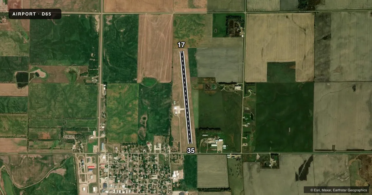
Airport sketch
Runways drawn to scale from FAA survey coordinates, rendered over satellite imagery. Not for navigation.
Approaches & charts
Services on the field
Fuel grades, oxygen, maintenance, ramp storage and lighting — as declared to the FAA by the airport operator.
Fuel & services
- Fuel
- 100LL
- Other services
- AGRI
Ramp & ground
- Transient storage
- Tie-down
- Landing fee
- No fee published
- Lighting schedule
- SEE RMK
- Beacon schedule
- SS-SR
- Beacon
- White / Green (civil land)(WG)
- Wind indicator
- Lighted
- Segmented circle
- No
Fuel & FBOs
Cheapest 100LL and Jet A on the field and nearby. Always confirm with the FBO before taxi.
Airport notes
Surface conditions, obstructions, local procedures, lighting outages and other notes published with each FAA cycle.
General notes
- FOR CD CTC MINNEAPOLIS ARTCC AT 651-463-5588.
Lighting notes
- ACTVT LIRL RWY 17/35 - CTAF.
Approach & departure obstructions
- 17RWY 17 MKD WITH WHITE & BLACK TIPPED MKR CONES.
- 35RWY 35 MKD WITH WHITE & BLACK TIPPED MKR CONES.
VFR map & nearby airports
VFR sectional. Tap any ICAO chip to open that airport.
Key facts · D65
Answer card- ICAO
- D65
- Name
- CORSICA MUNI
- Location
- CORSICA, SOUTH DAKOTA
- Elevation
- 1,580 ft MSL
- Traffic pattern altitude
- 2,580 ft MSL (1,000 AGL)
- Control tower
- Non-towered (use CTAF)
- Total runways
- 1
- Longest runway
- 17/35 · 3,400 ft
- Published ILS approaches
- 0
- Published frequencies
- 1
- Magnetic variation
- 7°
- Current flight rules
- IFR
- Current wind
- 310° at 4 kt
- Favored runway now
- RWY 35
Corsica Muni sits in Corsica, South Dakota. Field elevation is 1,580 ft MSL. The airport has one runway. Runway 17/35 is 3,400 ft of turf, which is the longest runway on the field.
This is an untowered airport. CTAF is 122.9. No ILS approaches are published here, so plan for VFR or non-ILS arrival options only. The published pattern altitude is not listed, so use the current Chart Supplement before you fly. The runway is marked with white and black tipped marker cones at both ends. Low intensity runway lights for Runway 17/35 are activated by the CTAF.
There are no on-field FBOs listed in the facts. Contact the airport operator directly before arrival, or call the field on CTAF for current fuel or service availability. If you need clearance delivery, Minneapolis ARTCC is listed in the remarks at 651-463-5588. With a turf runway and 7° magnetic variation, a first-time pilot should brief the surface condition and the lighting activation. Check the current Chart Supplement for any published noise or curfew restrictions before flying into the field.