METAR & TAF Y03
Y03 does not publish a METAR.
Showing the nearest reporting station: KAGZ (WAGNER MUNI) · 20.5 NM away. Conditions at Y03 may differ.
METAR · KAGZ
Observed 12:35Z
KAGZ 271235Z AUTO 34007KT 2 1/2SM BR FEW010 27/27 A2981 RMK AO2
- Wind
- 340° @ 7 kt
- Visibility
- 0.5 SM
- Temp / Dew
- 27°C / 27°C
- Altimeter
- 29.81 inHg
- Clouds
- FEW
- Density alt
- 3,218 ft
- Ceiling
- Unlimited
- Rules
- LIFR
Airport info & contacts
Manager on record, flight service, ARTCC, attendance schedule and pattern altitude — published by the FAA and refreshed every 28 days.
Location
- From city
- 1 NM N
- VFR sectional
- OMAHA
- ARTCC
- ZMP · MINNEAPOLIS
- NOTAM facility
- HON (NOTAM-D)
Airport manager
- Name
- DON BOYD
- Phone
- (605) 369-2309
- Address
- BOX 446, SPRINGFIELD SD 57062
Flight service · Hours
- FSS HON
- HURON1-800-WX-BRIEF
- Attendance
- Unattended
Frequencies
Tap any row to copy the frequency to your clipboard.
Runways & pattern
Full pagePattern entry · RWY 33
LEFT TRAFFIC| Runway | Heading (°M) | Length | Surface | Traffic |
|---|---|---|---|---|
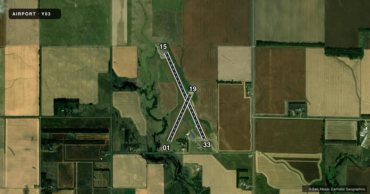
| 15/33Favored | 148° / 328° | 3,500 ft | ASPH | Standard L |
| 01/19 | 18° / 198° | 1,900 ft | TURF | Standard L |
Runway end performance
| End | TORA | TODA | ASDA | LDA | VGSI | Approach lights | Obstruction |
|---|---|---|---|---|---|---|---|
| 15 | — | — | — | — | PAPI 2-box left(3°) | — | — |
| 33 | — | — | — | — | PAPI 2-box left(3°) | — | 12', road, 590' from thr, 0' R of cntrln, slope 32 |
| 19 | — | — | — | — | — | — | 13', fence, 490' from thr, 0' R of cntrln, slope 37 |
Declared distances in feet. TORA = takeoff run available, TODA = takeoff distance, ASDA = accelerate-stop, LDA = landing distance.
Airport sketch
Runways drawn to scale from FAA survey coordinates, rendered over satellite imagery. Not for navigation.
Approaches & charts
Services on the field
Fuel grades, oxygen, maintenance, ramp storage and lighting — as declared to the FAA by the airport operator.
Fuel & services
- Fuel
- 100LLMOGAS
- Oxygen (bottled)
- Not available
- Oxygen (bulk)
- Not available
- Power plant repair
- Minor
- Other services
- AGRI
Ramp & ground
- Transient storage
- Tie-down
- Hangar
- Landing fee
- No fee published
- Customs
- Not available
- Lighting schedule
- SEE RMK
- Beacon schedule
- SS-SR
- Beacon
- White / Green (civil land)(WG)
- Wind indicator
- Lighted
- Segmented circle
- Yes
Fuel & FBOs
Cheapest 100LL and Jet A on the field and nearby. Always confirm with the FBO before taxi.
Airport notes
Surface conditions, obstructions, local procedures, lighting outages and other notes published with each FAA cycle.
General notes
- RY 01 HAS A FENCE 75 FT FM THLD; TOP OF FENCE IS 3 FT BLO RY END.
- WILDLIFE ON AND INVOF ARPT.
- FOR CD CTC MINNEAPOLIS ARTCC AT 651-463-5588.
Lighting notes
- ACTVT MIRL RY 15/33 AND PAPI RY 15/33 - CTAF.
Fuel notes
- 100LLSELF SVC 100LL & MOGAS AVBL 24HRS WITH CREDIT CARD.
Approach & departure obstructions
- 0101/19 MKD WITH WHITE AND BLACK PLASTIC MARKER CONES
VFR map & nearby airports
VFR sectional. Tap any ICAO chip to open that airport.
Key facts · Y03
Answer card- ICAO
- Y03
- Name
- SPRINGFIELD MUNI
- Location
- SPRINGFIELD, SOUTH DAKOTA
- Elevation
- 1,324 ft MSL
- Traffic pattern altitude
- 2,324 ft MSL (1,000 AGL)
- Control tower
- Non-towered (use CTAF)
- Total runways
- 2
- Longest runway
- 15/33 · 3,500 ft
- Published ILS approaches
- 0
- Published frequencies
- 1
- Magnetic variation
- 7°
- Current flight rules
- LIFR
- Current wind
- 340° at 7 kt
- Favored runway now
- RWY 33
Springfield Muni is in Springfield, South Dakota. The field elevation is 1,324 ft MSL. It has two runways. The longest is runway 15/33 at 3,500 ft. There is no control tower. CTAF is 122.9. No ILS approaches are published here.
Pattern altitude is not published in the facts. Use the standard 1,000 ft AGL pattern unless the current FAA Chart Supplement says otherwise. That puts the light piston pattern at 2,324 ft MSL based on the field elevation. Verify before you fly. The on-field FBO is Springfield Municipal Airport. It carries 100LL and mogas. Self-service fuel is available 24 hours with credit card.
A few operational details matter here. Runways 01 and 19 are marked with white and black plastic marker cones. Runway 01 has a fence 75 ft from the threshold. The top of that fence is 3 ft below the runway end. Wildlife is present on and near the airport, so keep your scan active on taxi, takeoff and landing. Runway 15/33 has medium intensity runway lights and PAPI. They are activated by CTAF. For clearance delivery, contact Minneapolis ARTCC at 651-463-5588. If you need current noise or local operating restrictions, check the current FAA Chart Supplement before departure.