METAR & TAF 0B4
0B4 does not publish a METAR.
Showing the nearest reporting station: KVMR (HAROLD DAVIDSON FLD) · 17.1 NM away. Conditions at 0B4 may differ.
METAR · KVMR
Observed 17:15Z
KVMR 271715Z AUTO 06010KT 10SM CLR 34/24 A2983 RMK AO2
- Wind
- 060° @ 10 kt
- Visibility
- 10 SM
- Temp / Dew
- 34°C / 24°C
- Altimeter
- 29.83 inHg
- Clouds
- CLR
- Density alt
- 4,113 ft
- Ceiling
- Unlimited
- Rules
- VFR
Airport info & contacts
Manager on record, flight service, ARTCC, attendance schedule and pattern altitude — published by the FAA and refreshed every 28 days.
Location
- From city
- 2 NM SE
- VFR sectional
- OMAHA
- ARTCC
- ZMP · MINNEAPOLIS
- NOTAM facility
- OLU (NOTAM-D)
Airport manager
- Name
- JOHN BECKER
- Phone
- 402-841-0486
- Address
- 56395 881 ROAD, HARTINGTON NE 68739-4021
Flight service · Hours
- FSS OLU
- COLUMBUS1-800-WX-BRIEF
- Attendance
- ALL
Frequencies
Tap any row to copy the frequency to your clipboard.
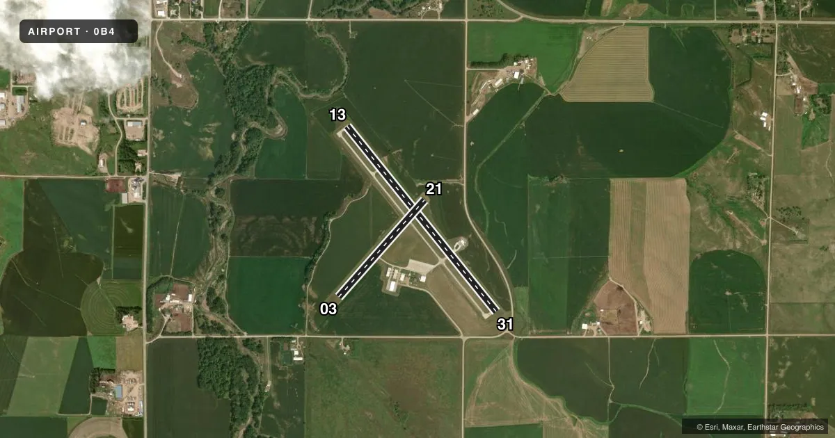
Runways & pattern
Full pagePattern entry · RWY 03
LEFT TRAFFIC| Runway | Heading (°M) | Length | Surface | Traffic |
|---|---|---|---|---|
| 13/31 | 135° / 315° | 3,950 ft | CONC | Standard L |
| 03/21Favored | 35° / 215° | 2,150 ft | TURF | Standard L |
Runway end performance
| End | TORA | TODA | ASDA | LDA | VGSI | Approach lights | Obstruction |
|---|---|---|---|---|---|---|---|
| 13 | — | — | — | — | PAPI 2-box left(3.5°) | — | 70', tree, 1487' from thr, 420' R of cntrln, slope 18 |
| 31 | — | — | — | — | PAPI 2-box left(3.25°) | — | — |
Declared distances in feet. TORA = takeoff run available, TODA = takeoff distance, ASDA = accelerate-stop, LDA = landing distance.
Airport sketch
Runways drawn to scale from FAA survey coordinates, rendered over satellite imagery. Not for navigation.
Approaches & charts
Services on the field
Fuel grades, oxygen, maintenance, ramp storage and lighting — as declared to the FAA by the airport operator.
Fuel & services
- Fuel
- 100LL
- Oxygen (bottled)
- Not available
- Oxygen (bulk)
- Not available
- Airframe repair
- Major
- Power plant repair
- Major
- Other services
- AGRI,INSTR
Ramp & ground
- Transient storage
- Tie-down
- Hangar
- Landing fee
- No fee published
- Lighting schedule
- SEE RMK
- Beacon schedule
- SS-SR
- Beacon
- White / Green (civil land)(WG)
- Wind indicator
- Lighted
- Segmented circle
- No
Fuel & FBOs
Cheapest 100LL and Jet A on the field and nearby. Always confirm with the FBO before taxi.
Airport notes
Surface conditions, obstructions, local procedures, lighting outages and other notes published with each FAA cycle.
General notes
- FOR CD CTC MINNEAPOLIS ARTCC AT 651-463-5588.
Lighting notes
- ACTVT PAPI RWY 13 & 31; MIRL RWY 13/31 - CTAF.
Fuel notes
- 100LLFOR FUEL CALL 402-254-7316 OR 402-841-0486.
Runway surface & condition
- 03/21NOT PLOWED DURING WINTER MONTHS.
Approach & departure obstructions
- 31RWY 31 CLOSE-IN OBSTN ROAD 223 RIGHT.
- 13RWY 13 TREE MASS 300 FT TO 470 FT R OF CNTRLN.
- 13RWY 13 TREE MASS 1330 FT TO 1250 FT FM RWY END.
- 03RWY 03 CLNC SLOPE 23:1 DUE TO TREE 42 FT ABV 1000 FT FM RWY END, 119 FT L.
- 21RWY 21 CLNC SLOPE 21;1 DUE TO ROAD 10 FT ABV 215 FT FM RWY END, 0B RWY 21 WATCH FOR CTR PIVOT ROTG INTO APCH DURG GROWING SEASON, CAN CREATE CLNC SLOPE AS LOW AS 18:1.
- 31RWY 31 APCH RATIO 21:1 TO DSPLCD THR DUE TO ROAD 31 FT ABV 675 FT FM DSPLCD THR, 351 FT L.
Other notes
- EXISTED PRIOR TO 1959.
- OWNERAIRPORT AUTHORITY CHAIRMAN IS KARMA SCHULTE
- MANAGERMOBILE PHONE 402-841-0486 (MANAGER)
VFR map & nearby airports
VFR sectional. Tap any ICAO chip to open that airport.
Key facts · 0B4
Answer card- ICAO
- 0B4
- Name
- HARTINGTON MUNI/BUD BECKER FLD
- Location
- HARTINGTON, NEBRASKA
- Elevation
- 1,388.1 ft MSL
- Traffic pattern altitude
- 2,388.1 ft MSL (1,000 AGL)
- Control tower
- Non-towered (use CTAF)
- Total runways
- 2
- Longest runway
- 13/31 · 3,950 ft
- Published ILS approaches
- 0
- Published frequencies
- 1
- Magnetic variation
- 6°
- Current flight rules
- VFR
- Current wind
- 060° at 10 kt
- Favored runway now
- RWY 03
Hartington Muni/Bud Becker Fld sits in Hartington, Nebraska. Field elevation is 1,388.1 ft MSL. The airport has two runways. The longest is 13/31 at 3,950 ft of concrete. Runway 03/21 is 2,150 ft of turf. There is no control tower. CTAF is 122.9.
No ILS approaches are published here. Pattern altitude is not published, so a light piston pilot should plan on the standard 1,000 ft AGL unless the current Chart Supplement says otherwise. That puts the traffic pattern at about 2,388 ft MSL based on the field elevation, but verify the current published pattern before you go.
Becker Flying Service is on the field. It carries 100LL. Call ahead at (402) 254-7316 for current fuel or field status. Published remarks also note that runway 03/21 is not plowed in winter. Runway 13/31 has PAPI and medium intensity lights controlled by CTAF. Watch the published obstruction notes closely. Runway 31 has a road close to the right side. Runway 21 has road and pivot hazards near the approach path. Runway 03 has a tree-related clearance issue on final. For clearance delivery, contact Minneapolis ARTCC. This is a non-towered field with a single paved runway that will handle most local GA traffic, but the terrain and obstruction notes mean a careful stabilized approach matters here.