METAR & TAF KYKN
Current METAR
Observed 01:56Z
KYKN 270156Z AUTO 11005KT 10SM CLR 32/28 A2974 RMK AO2 SLP067 T03170278
- Wind
- 110° @ 5 kt
- Visibility
- 10 SM
- Temp / Dew
- 32°C / 28°C
- Altimeter
- 29.74 inHg
- Clouds
- CLR
- Density alt
- 3,883 ft
- Ceiling
- Unlimited
- Rules
- VFR
Airport info & contacts
Manager on record, flight service, ARTCC, attendance schedule and pattern altitude — published by the FAA and refreshed every 28 days.
Location
- From city
- 3 NM N
- VFR sectional
- OMAHA
- ARTCC
- ZMP · MINNEAPOLIS
- NOTAM facility
- YKN (NOTAM-D)
Airport manager
- Name
- MIKE ROINSTAD
- Phone
- 605-661-9223
- Address
- 700 EAST 31ST STREET, YANKTON SD 57078
Flight service · Hours
- FSS HON
- HURON1-800-WX-BRIEF
- Attendance
- MON-FRI · 0800-1700
Frequencies
Tap any row to copy the frequency to your clipboard.
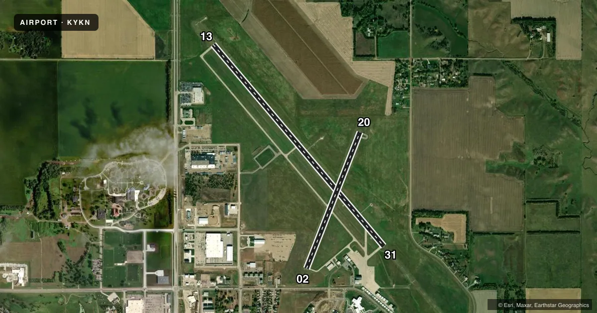
Runways & pattern
Full pagePattern entry · RWY 13
LEFT TRAFFIC| Runway | Heading (°M) | Length | Surface | Traffic |
|---|---|---|---|---|
| 13/31Favored | 137° / 317° | 6,094 ft | CONC | Standard L |
| 02/20 | 18° / 198° | 3,380 ft | ASPH | Standard L |
Runway end performance
| End | TORA | TODA | ASDA | LDA | VGSI | Approach lights | Obstruction |
|---|---|---|---|---|---|---|---|
| 13 | — | — | — | — | VASI 4-box left(3°) | — | — |
| 31 | — | — | — | — | VASI 4-box left(3°) | MALSR | — |
| 02 | — | — | — | — | PAPI 2-box left(3°) | — | 7', pline, 385' from thr, 94' R of cntrln, slope 26 |
| 20 | — | — | — | — | PAPI 2-box left(3°) | — | 6', fence, 382' from thr, 11' R of cntrln, slope 30 |
Declared distances in feet. TORA = takeoff run available, TODA = takeoff distance, ASDA = accelerate-stop, LDA = landing distance.
Airport sketch
Runways drawn to scale from FAA survey coordinates, rendered over satellite imagery. Not for navigation.
Approaches & charts
ILS · 1
Services on the field
Fuel grades, oxygen, maintenance, ramp storage and lighting — as declared to the FAA by the airport operator.
Fuel & services
- Fuel
- 100LLA
- Oxygen (bottled)
- Not available
- Oxygen (bulk)
- Not available
- Airframe repair
- Major
- Power plant repair
- Major
- Other services
- AGRI,CHTR,INSTR,RNTL,SALES
Ramp & ground
- Transient storage
- Tie-down
- Hangar
- Landing fee
- No fee published
- Customs
- Not available
- Lighting schedule
- SEE RMK
- Beacon schedule
- SS-SR
- Beacon
- White / Green (civil land)(WG)
- Wind indicator
- Lighted
- Segmented circle
- Yes
Fuel & FBOs
Cheapest 100LL and Jet A on the field and nearby. Always confirm with the FBO before taxi.
Airport notes
Surface conditions, obstructions, local procedures, lighting outages and other notes published with each FAA cycle.
General notes
- MIGRATORY WATERFOWL ON & INVOF ARPT.
- PAEW MOWING SEASONAL.
- FOR CD CTC MINNEAPOLIS ARTCC AT 651-463-5588.
Lighting notes
- ACTVT MALSR RWY 31; REILS RWY 13; PAPI RWY 02 & 20; HIRL RWY 13/31; MIRL RWY 02/20 - CTAF.
Other notes
- 1FOR SVC AFT 1700 CALL 605-661-9223.
VFR map & nearby airports
VFR sectional. Tap any ICAO chip to open that airport.
Key facts · KYKN
Answer card- ICAO
- KYKN
- Name
- CHAN GURNEY MUNI
- Location
- YANKTON, SOUTH DAKOTA
- Elevation
- 1,305.9 ft MSL
- Traffic pattern altitude
- 2,305.9 ft MSL (1,000 AGL)
- Control tower
- Non-towered (use CTAF)
- Total runways
- 2
- Longest runway
- 13/31 · 6,094 ft
- Published ILS approaches
- 1
- Published frequencies
- 2
- Magnetic variation
- 3°
- Current flight rules
- VFR
- Current wind
- 110° at 5 kt
- Favored runway now
- RWY 13
Chan Gurney Muni is in Yankton, South Dakota. The field elevation is 1,305.9 ft MSL. It has two runways. The longest is 6,094 ft on runway 13/31. This is an uncontrolled airport. CTAF and UNICOM are both 122.8.
Runway 31 has the published ILS approach. The field also has approach lighting for 31. Runway 13 has runway end identifier lights. PAPI is available on runways 02 and 20. High intensity runway lights are on 13/31. Medium intensity runway lights are on 02/20. The pattern altitude is not published. Use the standard 1,000 ft AGL for light piston traffic unless the current Chart Supplement says otherwise.
Chan Gurney Municipal Airport is the on-field FBO. It carries AVGAS 100LL and Jet A Prist. For service after 1700, call the airport at 605-661-9223. Seasonal mowing happens here. Migratory waterfowl are present on and near the airport, so keep a sharp scan on arrival and departure. Clearance delivery is handled through Minneapolis ARTCC at 651-463-5588. If you are planning a night arrival or an instrument approach, brief the runway 31 lighting setup before you launch.