METAR & TAF KLCG
Current METAR
Observed 20:15Z
KLCG 272015Z AUTO 06010KT 10SM CLR 35/20 A2983 RMK AO2 T03470195
- Wind
- 060° @ 10 kt
- Visibility
- 10 SM
- Temp / Dew
- 35°C / 20°C
- Altimeter
- 29.83 inHg
- Clouds
- CLR
- Density alt
- 4,287 ft
- Ceiling
- Unlimited
- Rules
- VFR
Airport info & contacts
Manager on record, flight service, ARTCC, attendance schedule and pattern altitude — published by the FAA and refreshed every 28 days.
Location
- From city
- 2 NM E
- VFR sectional
- OMAHA
- ARTCC
- ZMP · MINNEAPOLIS
- NOTAM facility
- LCG (NOTAM-D)
Airport manager
- Name
- TOM BECKER
- Phone
- 402-841-0659
- Address
- 56395 881 ROAD, HARTINGTON NE 68739-0188
Flight service · Hours
- FSS OLU
- COLUMBUS1-800-WX-BRIEF
- Attendance
- DAWN - DUSK
Frequencies
Tap any row to copy the frequency to your clipboard.
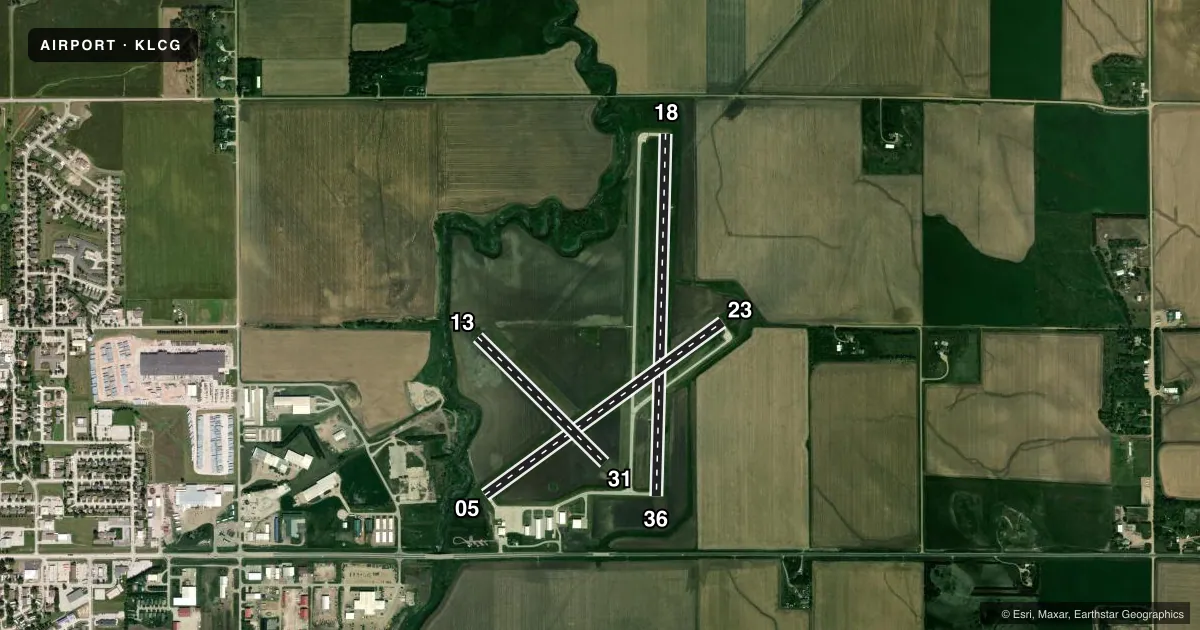
Runways & pattern
Full pagePattern entry · RWY 05
LEFT TRAFFIC| Runway | Heading (°M) | Length | Surface | Traffic |
|---|---|---|---|---|
| 18/36 | 175° / 355° | 4,201 ft | CONC | Standard L |
| 05/23Favored | 48° / 228° | 3,406 ft | CONC | Standard L |
| 13/31 | 129° / 309° | 2,070 ft | TURF | Standard L |
Runway end performance
| End | TORA | TODA | ASDA | LDA | VGSI | Approach lights | Obstruction |
|---|---|---|---|---|---|---|---|
| 18 | — | — | — | — | PAPI 2-box left(3°) | — | — |
| 36 | — | — | — | — | PAPI 2-box left(3°) | — | — |
Declared distances in feet. TORA = takeoff run available, TODA = takeoff distance, ASDA = accelerate-stop, LDA = landing distance.
Airport sketch
Runways drawn to scale from FAA survey coordinates, rendered over satellite imagery. Not for navigation.
Approaches & charts
Services on the field
Fuel grades, oxygen, maintenance, ramp storage and lighting — as declared to the FAA by the airport operator.
Fuel & services
- Fuel
- 100LL
- Oxygen (bottled)
- Not available
- Oxygen (bulk)
- Not available
- Airframe repair
- Major
- Power plant repair
- Major
- Other services
- AGRI
Ramp & ground
- Transient storage
- Tie-down
- Hangar
- Landing fee
- No fee published
- Customs
- Not available
- Lighting schedule
- SEE RMK
- Beacon schedule
- SS-SR
- Beacon
- White / Green (civil land)(WG)
- Wind indicator
- Lighted
- Segmented circle
- Yes
Fuel & FBOs
Cheapest 100LL and Jet A on the field and nearby. Always confirm with the FBO before taxi.
Airport notes
Surface conditions, obstructions, local procedures, lighting outages and other notes published with each FAA cycle.
General notes
- DEER ON AND INVOF ARPT.
- FOR CD CTC SIOUX CITY APCH AT 712-293-2482. WHEN SIOUX CITY APCH CLSD, FOR CD CTC MINNEAPOLIS ARTCC AT 651-463-5588.
Lighting notes
- PAPI RWY 18 & 36; MIRL RWYS 05/23, 18/36; OPR SS-2300. AFT 2300, ACTVT - CTAF.
Runway surface & condition
- 13/31RWY 31 END APCH CROSSES RWY 36 END APCH. NOT PLOWED WINTER MONTHS.
- 18/36RWY 36 END APCH CROSSES RWY 31 END APCH.
Approach & departure obstructions
- 05RWY 05 CLNC SLOPE 25:1 DUE TO POLE 39 FT ABV; 1209 FT FM RWY END 66 FT L.
- 18RWY 18 CLNC SLOPE 22:1 DUE TO ROAD 10 FT ABV; 423 FT FM RWY END 283 FT L/R.
- 23RWY 23 CLNC SLOPE 39:1 DUE TO HILL 134 FT ABV; 5500 FT FM RWY END 850 FT L.
Other notes
- PROVIDED APPROACH TO EACH RUNWY IS MAINTAINED FOR A MINIMUM 20:1 GLIDE SLOPE & THE TRANSITIONAL SURFACE BE MAINTAINED FOR A 7:1 SLOPE.
- CALL FOR TSNT HNGR USE 402-369-6920.
- OWNERTRAVIS MEYER , OPERATIONS MANAGER, PHONE 402-369-6920.
VFR map & nearby airports
VFR sectional. Tap any ICAO chip to open that airport.
Key facts · KLCG
Answer card- ICAO
- KLCG
- Name
- WAYNE MUNI/STAN MORRIS FLD
- Location
- WAYNE, NEBRASKA
- Elevation
- 1,431.7 ft MSL
- Traffic pattern altitude
- 2,431.7 ft MSL (1,000 AGL)
- Control tower
- Non-towered (use CTAF)
- Total runways
- 3
- Longest runway
- 18/36 · 4,201 ft
- Published ILS approaches
- 0
- Published frequencies
- 4
- Magnetic variation
- 6°
- Current flight rules
- VFR
- Current wind
- 060° at 10 kt
- Favored runway now
- RWY 05
Wayne Muni/Stan Morris Fld sits in Wayne, Nebraska. Field elevation is 1,431.7 ft MSL. It is a non-towered airport with three runways. The longest is runway 18/36 at 4,201 ft. No ILS approaches are published here. Pattern altitude is not published, so plan on the standard 1,000 ft AGL for light piston traffic unless the current FAA Chart Supplement says otherwise.
The on-field FBO is Wayne Municipal Airport. It carries 100LL. Call (402) 369-6920 for current service details or transient hangar use. CTAF and UNICOM are both 122.8. Sioux City Approach handles clearance delivery and approach support on 124.6 or 307.0. If Sioux City Approach is closed, clearance delivery goes to Minneapolis ARTCC. The published remarks also matter here. Runway 18 has a clearance slope note because of a road near the approach. Runway 23 has a hill in the departure area. Deer are reported on and near the airport. Runway 31 is not plowed in winter. Lighting is available on 05/23 and 18/36, with activation on CTAF after 2300.
For a first-time arrival, pay attention to the runway geometry and the crossing approach paths near 31 and 36. The field sits in open country, so wind and winter surface conditions can change the picture fast. Check the current FAA Chart Supplement for any updated operational notes before you go.