METAR & TAF KSCB
KSCB does not publish a METAR.
Showing the nearest reporting station: KFET (FREMONT MUNI) · 10.8 NM away. Conditions at KSCB may differ.
METAR · KFET
Observed 17:15Z
KFET 271715Z AUTO 04003KT 10SM CLR 33/23 A2980 RMK AO2 T03310234
- Wind
- 040° @ 3 kt
- Visibility
- 10 SM
- Temp / Dew
- 33°C / 23°C
- Altimeter
- 29.80 inHg
- Clouds
- CLR
- Density alt
- 3,952 ft
- Ceiling
- Unlimited
- Rules
- VFR
Airport info & contacts
Manager on record, flight service, ARTCC, attendance schedule and pattern altitude — published by the FAA and refreshed every 28 days.
Location
- From city
- 3 NM SE
- VFR sectional
- OMAHA
- ARTCC
- ZMP · MINNEAPOLIS
- NOTAM facility
- OLU (NOTAM-D)
Airport manager
- Name
- CHRIS HOWARD
- Phone
- 402-480-2434
- Address
- 3227 NEBRASKA AVE, SCRIBNER STATE AIRFIELD, FREMONT NE 68025-2205
Flight service · Hours
- FSS OLU
- COLUMBUS1-800-WX-BRIEF
- Attendance
- MON-FRI · 0700-1600
Frequencies
Tap any row to copy the frequency to your clipboard.
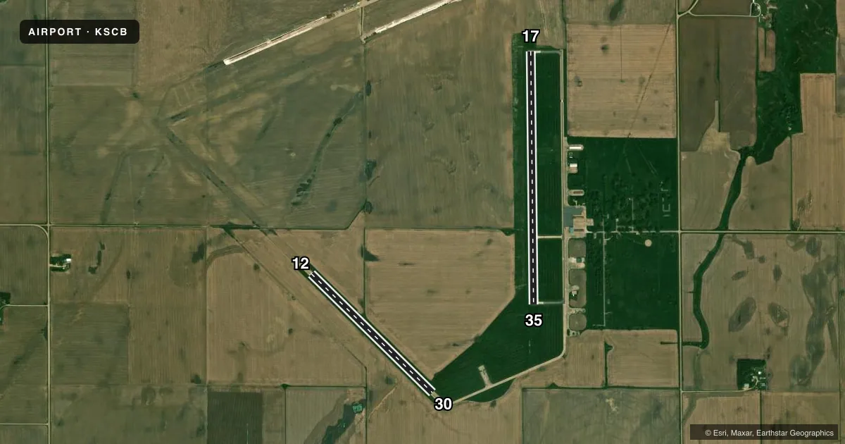
Runways & pattern
Full pagePattern entry · RWY 35
LEFT TRAFFICAirport sketch
Runways drawn to scale from FAA survey coordinates, rendered over satellite imagery. Not for navigation.
Approaches & charts
Services on the field
Fuel grades, oxygen, maintenance, ramp storage and lighting — as declared to the FAA by the airport operator.
Fuel & services
- Fuel
- 100LL
- Oxygen (bottled)
- Not available
- Oxygen (bulk)
- Not available
- Airframe repair
- Not available
- Power plant repair
- Not available
- Other services
- AGRI
Ramp & ground
- Transient storage
- Tie-down
- Landing fee
- No fee published
- Customs
- Not available
- Lighting schedule
- SEE RMK
- Beacon schedule
- SEE RMK
- Beacon
- White / Green (civil land)(WG)
- Wind indicator
- Lighted
- Segmented circle
- Yes
Fuel & FBOs
Cheapest 100LL and Jet A on the field and nearby. Always confirm with the FBO before taxi.
Airport notes
Surface conditions, obstructions, local procedures, lighting outages and other notes published with each FAA cycle.
General notes
- FOR CD CTC OMAHA APCH AT 402-682-4395.
Lighting notes
- ROTG BCN OTS INDEF.
- ACTVT MIRL RWY 17/35 - CTAF.
Fuel notes
- 100LLCTC AMGR FOR FUEL. CASH OR CHECK ONLY.
Other notes
- WINDSOCK TMPRY UNLGTD.
- MANAGERSHOP FONE 402-654-2200.
- 12/3012/30 2019 PCI SCORE RATED AS POOR; RWY HAS HIGH SEVERITY LINEAR CRACKS THROUGHOUT RWY, FOD PRESENT.
VFR map & nearby airports
VFR sectional. Tap any ICAO chip to open that airport.
Key facts · KSCB
Answer card- ICAO
- KSCB
- Name
- SCRIBNER STATE
- Location
- SCRIBNER, NEBRASKA
- Elevation
- 1,324.9 ft MSL
- Traffic pattern altitude
- 2,324.9 ft MSL (1,000 AGL)
- Control tower
- Non-towered (use CTAF)
- Total runways
- 2
- Longest runway
- 17/35 · 4,200 ft
- Published ILS approaches
- 0
- Published frequencies
- 3
- Magnetic variation
- 3°
- Current flight rules
- VFR
- Current wind
- 040° at 3 kt
- Favored runway now
- RWY 35
Scribner State Airport is in Scribner, Nebraska. The field elevation is 1,324.9 ft MSL. It has two concrete runways. The longest is 17/35 at 4,200 ft. Runway 12/30 is 2,820 ft. This is an untowered field, so expect self-announce traffic on CTAF 122.9.
No ILS approaches are published here. Pattern altitude is not published, so use the standard 1,000 ft AGL for light piston operations unless the current Chart Supplement says otherwise. Omaha Approach handles clearance delivery. The published frequencies include 135.875 and 354.05 for Omaha Approach or Departure.
A few remarks matter for planning. Runway 12/30 has a poor pavement condition rating with cracking and reported foreign object debris. Plan your runway choice with that in mind. The rotating beacon is out of service indefinitely. The windsock is temporarily unlighted. Runway 17/35 has medium intensity lights that are activated by the CTAF.
There are no on-field FBOs listed. Fuel is handled through the airport manager. The published note says payment is cash or check only. Call the manager at 402-654-2200 before arrival if you need fuel or field status. For a first-time pilot, the main things are the short-field environment, the runway condition on 12/30 and the lack of a tower. Check the current Chart Supplement before you go.