METAR & TAF KOLU
Current METAR
Observed 12:56Z
KOLU 271256Z AUTO 24005KT 10SM CLR 27/23 A2978 RMK AO2 SLP070 T02720228
- Wind
- 240° @ 5 kt
- Visibility
- 10 SM
- Temp / Dew
- 27°C / 23°C
- Altimeter
- 29.78 inHg
- Clouds
- CLR
- Density alt
- 3,408 ft
- Ceiling
- Unlimited
- Rules
- VFR
Airport info & contacts
Manager on record, flight service, ARTCC, attendance schedule and pattern altitude — published by the FAA and refreshed every 28 days.
Location
- From city
- 1 NM NE
- VFR sectional
- OMAHA
- ARTCC
- ZMP · MINNEAPOLIS
- NOTAM facility
- OLU (NOTAM-D)
Airport manager
- Name
- ROSS NIEDBALSKI
- Phone
- 402-276-5284
- Address
- PO BOX 1677, 1308 BILL BABKA DRIVE, 2765 14TH AVE, COLUMBUS NE 68602-1677
Flight service · Hours
- FSS OLU
- COLUMBUS1-800-WX-BRIEF
- Attendance
- DALGT
Frequencies
Tap any row to copy the frequency to your clipboard.
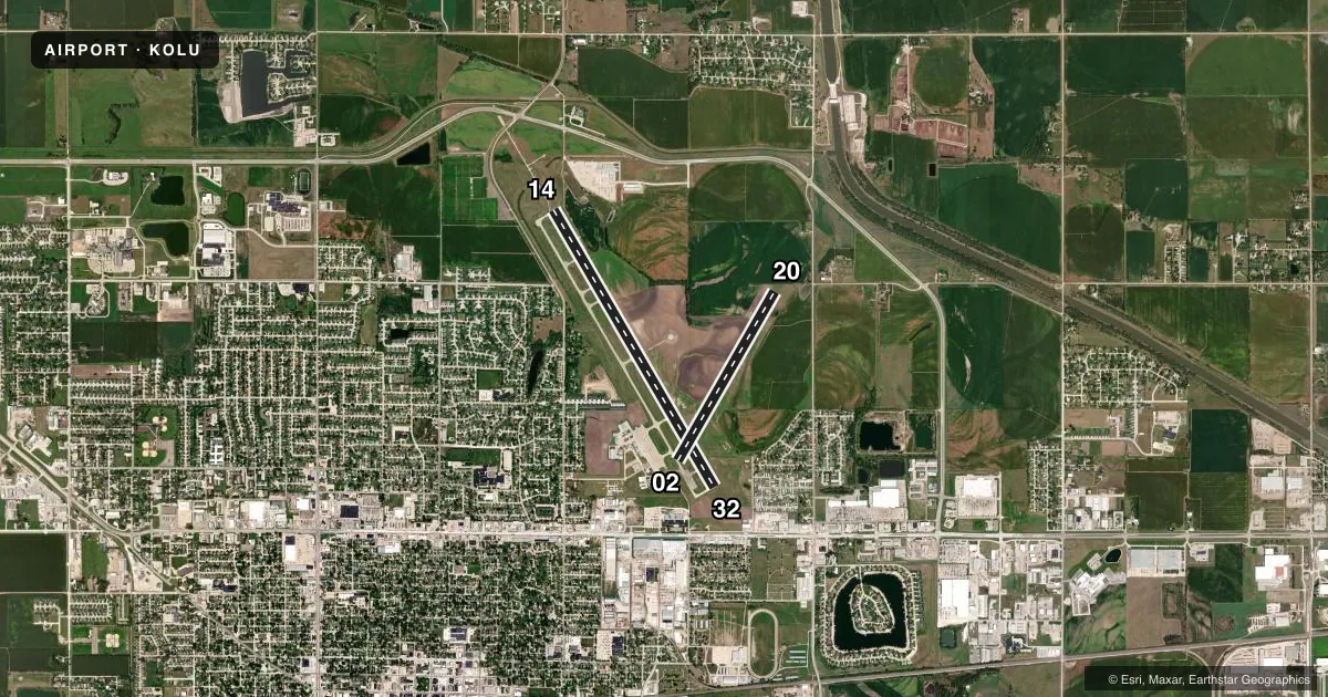
Runways & pattern
Full pagePattern entry · RWY 20
LEFT TRAFFIC| Runway | Heading (°M) | Length | Surface | Traffic |
|---|---|---|---|---|
| 14/32 | 147° / 327° | 6,801 ft | CONC | Standard L |
| 02/20Favored | 27° / 207° | 4,135 ft | TURF | Standard L |
Runway end performance
| End | TORA | TODA | ASDA | LDA | VGSI | Approach lights | Obstruction |
|---|---|---|---|---|---|---|---|
| 14 | 6,800' | 6,800' | 6,260' | 6,260' | PAPI 4-box left(3°) | MALSR | — |
| 32 | 6,800' | 6,800' | 6,800' | 5,850' | VASI 4-box left(3°) | — | 60', tree, 1275' from thr, 619' R of cntrln, slope 17 |
Declared distances in feet. TORA = takeoff run available, TODA = takeoff distance, ASDA = accelerate-stop, LDA = landing distance.
Airport sketch
Runways drawn to scale from FAA survey coordinates, rendered over satellite imagery. Not for navigation.
Approaches & charts
ILS · 1
Services on the field
Fuel grades, oxygen, maintenance, ramp storage and lighting — as declared to the FAA by the airport operator.
Fuel & services
- Fuel
- 100LLA
- Oxygen (bottled)
- Not available
- Oxygen (bulk)
- Not available
- Airframe repair
- Major
- Power plant repair
- Major
- Other services
- AFRT,INSTR,RNTL
Ramp & ground
- Transient storage
- Tie-down
- Hangar
- Landing fee
- No fee published
- Customs
- Not available
- Lighting schedule
- SEE RMK
- Beacon schedule
- SS-SR
- Beacon
- White / Green (civil land)(WG)
- Wind indicator
- Lighted
- Segmented circle
- Yes
Fuel & FBOs
Cheapest 100LL and Jet A on the field and nearby. Always confirm with the FBO before taxi.
Airport notes
Surface conditions, obstructions, local procedures, lighting outages and other notes published with each FAA cycle.
General notes
- WATERFOWL INVOF ARPT.
- DEER INVOF ARPT.
- RY 32 IS DESIGNATED AS THE CALM WIND RY.
- FOR CD IF UNA TO CTC ON FSS FREQ, CTC MINNEAPOLIS ARTCC AT 651-463-5588.
Lighting notes
- ACTVT MIRL RY 14/32; PAPI RY 14; VASI RY 32; REIL RY 32 & MALSR RY 14 - CTAF.
Fuel notes
- 100LLFOR FUEL AFT HRS CONTACT 402-910-5246.
Runway surface & condition
- 02/20RY 02/20 NOT PLOWED WINTER MONTHS.
Approach & departure obstructions
- 02RWY 02 END CONES MARK DSPLCD THLD; NOT RWY END.
- 02BOUNDARY MARKERS-G.
- 14RWY 32 CLNC SLOPE 37:1 TO DSPLCD THR.
Other notes
- 1FOR SVC AFT DARK CALL 402-910-5246.
- OWNERSHURAYA CHOAT, CITY CLERK
VFR map & nearby airports
VFR sectional. Tap any ICAO chip to open that airport.
Key facts · KOLU
Answer card- ICAO
- KOLU
- Name
- COLUMBUS MUNI
- Location
- COLUMBUS, NEBRASKA
- Elevation
- 1,447.3 ft MSL
- Traffic pattern altitude
- 2,447.3 ft MSL (1,000 AGL)
- Control tower
- Non-towered (use CTAF)
- Total runways
- 2
- Longest runway
- 14/32 · 6,801 ft
- Published ILS approaches
- 1
- Published frequencies
- 2
- Magnetic variation
- 3°
- Current flight rules
- VFR
- Current wind
- 240° at 5 kt
- Favored runway now
- RWY 20
Columbus Muni sits in Columbus, Nebraska. The field elevation is 1,447.3 ft MSL. It has two runways. The longest is runway 14/32 at 6,801 ft. There is no control tower. CTAF and UNICOM are both 123.05. One ILS approach is published for runway 14.
The pattern altitude is not published. Use the standard 1,000 ft AGL for light piston traffic unless the current FAA Chart Supplement says otherwise. Avcraft is on the field. It carries 100LL and Jet A. Call ahead at (402) 564-7884 if you need current service details.
A few operational notes matter here. Waterfowl are reported in the area. Runway 02 has a steep clearance issue near the approach path because of a grain elevator leg. Runway 20 center pivot can be active during irrigation season. Runway 02/20 is not plowed in winter. Runway 32 is the calm wind runway. Lighting is available on 14/32. Runway 14 has a PAPI and approach lighting. Runway 32 has a VASI and runway end identifier lights. If you need after-dark service, the published remarks point you to the phone number on file.