METAR & TAF 93Y
93Y does not publish a METAR.
Showing the nearest reporting station: KOLU (COLUMBUS MUNI) · 16.4 NM away. Conditions at 93Y may differ.
METAR · KOLU
Observed 11:56Z
KOLU 271156Z AUTO 17005KT 10SM CLR 25/22 A2976 RMK AO2 SLP064 T02500222 10294 20244 58003
- Wind
- 170° @ 5 kt
- Visibility
- 10 SM
- Temp / Dew
- 25°C / 22°C
- Altimeter
- 29.76 inHg
- Clouds
- CLR
- Density alt
- 3,404 ft
- Ceiling
- Unlimited
- Rules
- VFR
Airport info & contacts
Manager on record, flight service, ARTCC, attendance schedule and pattern altitude — published by the FAA and refreshed every 28 days.
Location
- From city
- 1 NM S
- VFR sectional
- OMAHA
- ARTCC
- ZMP · MINNEAPOLIS
- NOTAM facility
- OLU (NOTAM-D)
Airport manager
- Name
- CHRIS KROESING
- Phone
- 402-367-3109
- Address
- 174 WEST E STREET, DAVID CITY NE 68632-1531
Flight service · Hours
- FSS OLU
- COLUMBUS1-800-WX-BRIEF
- Attendance
- Unattended
Frequencies
Tap any row to copy the frequency to your clipboard.
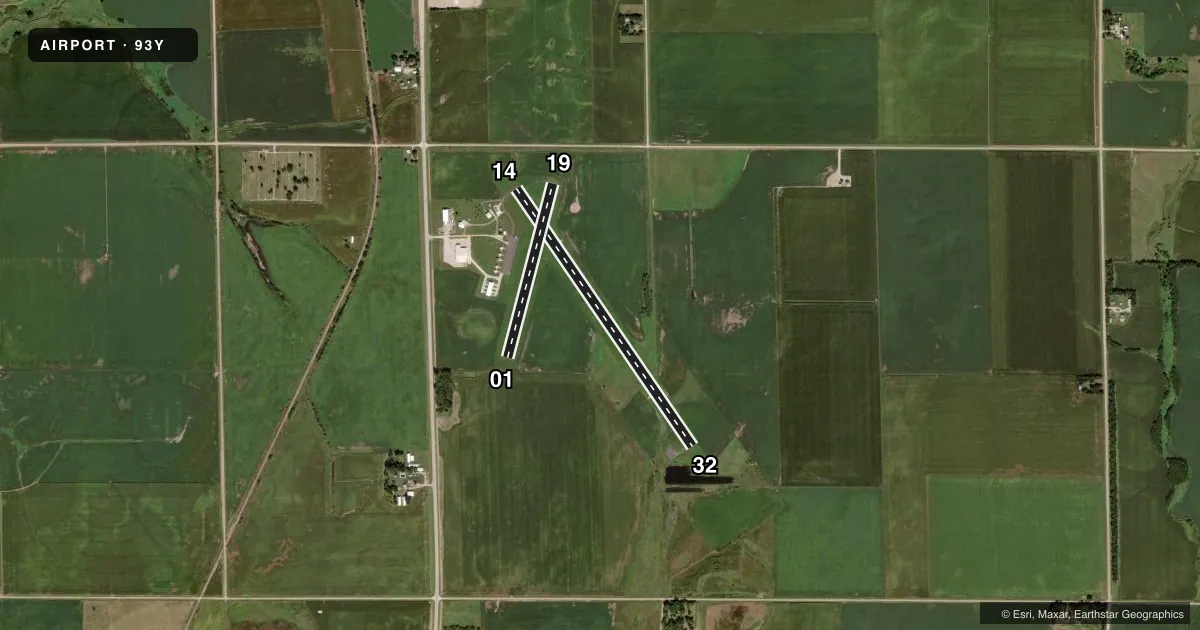
Runways & pattern
Full pagePattern entry · RWY 14
LEFT TRAFFIC| Runway | Heading (°M) | Length | Surface | Traffic |
|---|---|---|---|---|
| 14/32Favored | 141° / 321° | 3,676 ft | ASPH | 32 R |
| 01/19 | 10° / 190° | 2,114 ft | TURF | 01 R |
Runway end performance
| End | TORA | TODA | ASDA | LDA | VGSI | Approach lights | Obstruction |
|---|---|---|---|---|---|---|---|
| 14 | 3,675' | 3,675' | 3,675' | 3,600' | PAPI 2-box left(3°) | — | 13', road, 422' from thr, 0' R of cntrln, slope 16 |
| 32 | 3,675' | 3,675' | 3,675' | 3,675' | PAPI 2-box left(3°) | — | — |
Declared distances in feet. TORA = takeoff run available, TODA = takeoff distance, ASDA = accelerate-stop, LDA = landing distance.
Airport sketch
Runways drawn to scale from FAA survey coordinates, rendered over satellite imagery. Not for navigation.
Approaches & charts
Services on the field
Fuel grades, oxygen, maintenance, ramp storage and lighting — as declared to the FAA by the airport operator.
Fuel & services
- Fuel
- 100LL
- Oxygen (bottled)
- Not available
- Oxygen (bulk)
- Not available
- Airframe repair
- Not available
- Power plant repair
- Not available
- Other services
- AGRI
Ramp & ground
- Transient storage
- Tie-down
- Landing fee
- No fee published
- Customs
- Not available
- Lighting schedule
- SEE RMK
- Beacon schedule
- SS-SR
- Beacon
- White / Green (civil land)(WG)
- Wind indicator
- Lighted
- Segmented circle
- Yes
Fuel & FBOs
Cheapest 100LL and Jet A on the field and nearby. Always confirm with the FBO before taxi.
Airport notes
Surface conditions, obstructions, local procedures, lighting outages and other notes published with each FAA cycle.
General notes
- FOR CD CTC OMAHA APCH AT 402-682-4395.
- FUEL AVBL H24 VIA CREDIT CARD.
Lighting notes
- ACTVT PAPI RWY 14 & 32; MIRL RWY 14/32 - CTAF.
Approach & departure obstructions
- 32SMALL 1 FT TREES 139 FT FM RWY END 168 FT L.
- 14RWY 14 CLNC SLP 33:1 FOR TREE 1892 FT OUT, 58 FT ABV, 89R. 37:1 FM DSPLCD THLD FOR ROAD.
Other notes
- ESTAB PRIOR TO 1959.
- MANAGERFOR SVCS OR EMERG, CALL 402-367-3109/7400.
VFR map & nearby airports
VFR sectional. Tap any ICAO chip to open that airport.
Key facts · 93Y
Answer card- ICAO
- 93Y
- Name
- DAVID CITY MUNI
- Location
- DAVID CITY, NEBRASKA
- Elevation
- 1,617.7 ft MSL
- Traffic pattern altitude
- 2,617.7 ft MSL (1,000 AGL)
- Control tower
- Non-towered (use CTAF)
- Total runways
- 2
- Longest runway
- 14/32 · 3,676 ft
- Published ILS approaches
- 0
- Published frequencies
- 3
- Magnetic variation
- 5°
- Current flight rules
- VFR
- Current wind
- 170° at 5 kt
- Favored runway now
- RWY 14
David City Muni is in David City, Nebraska. The field elevation is 1,617.7 ft MSL. It has two runways. The longest is 14/32 at 3,676 ft asphalt. Runway 01/19 is 2,114 ft turf. There is no control tower. Pattern altitude is not published. For light piston planning, use 1,000 ft AGL unless the current Chart Supplement says otherwise.
No ILS approaches are published here. The airport uses CTAF 122.9. Omaha Approach handles approach and departure services on 124.0 and 270.3. The on-field FBO is David City Municipal Airport. It carries 100LL. Fuel is available 24 hours a day via credit card.
A first-time pilot should pay attention to the runway notes. Runway 19 has a road close to the end that creates a steeper clearance picture. Runway 14 has tree and road clearance notes near the approach end. Runway 01 also has a fence note near the end. Runway 01/19 is not plowed during winter months. The runway lights and PAPI for 14/32 are activated on CTAF. This is a non-towered field with published obstructions. A careful self-brief on runway choice and wind is smart before arrival.