METAR & TAF KCEK
KCEK does not publish a METAR.
Showing the nearest reporting station: KLNK (LINCOLN) · 15.9 NM away. Conditions at KCEK may differ.
METAR · KLNK
Observed 19:54Z
KLNK 271954Z 04008KT 5SM HZ FEW009 36/23 A2979 RMK AO2 SLP071 T03610233
- Wind
- 040° @ 8 kt
- Visibility
- 5 SM
- Temp / Dew
- 36°C / 23°C
- Altimeter
- 29.79 inHg
- Clouds
- FEW
- Density alt
- 4,541 ft
- Ceiling
- Unlimited
- Rules
- MVFR
Airport info & contacts
Manager on record, flight service, ARTCC, attendance schedule and pattern altitude — published by the FAA and refreshed every 28 days.
Location
- From city
- 2 NM E
- VFR sectional
- OMAHA
- ARTCC
- ZMP · MINNEAPOLIS
- NOTAM facility
- OLU (NOTAM-D)
Airport manager
- Name
- JUSTIN HAACK
- Phone
- 402-826-4408
- Address
- 2429 COUNTY ROAD F, CRETE AVIATION, CRETE NE 68333-0014
Flight service · Hours
- FSS OLU
- COLUMBUS1-800-WX-BRIEF
- Attendance
- 0800-1800
Frequencies
Tap any row to copy the frequency to your clipboard.
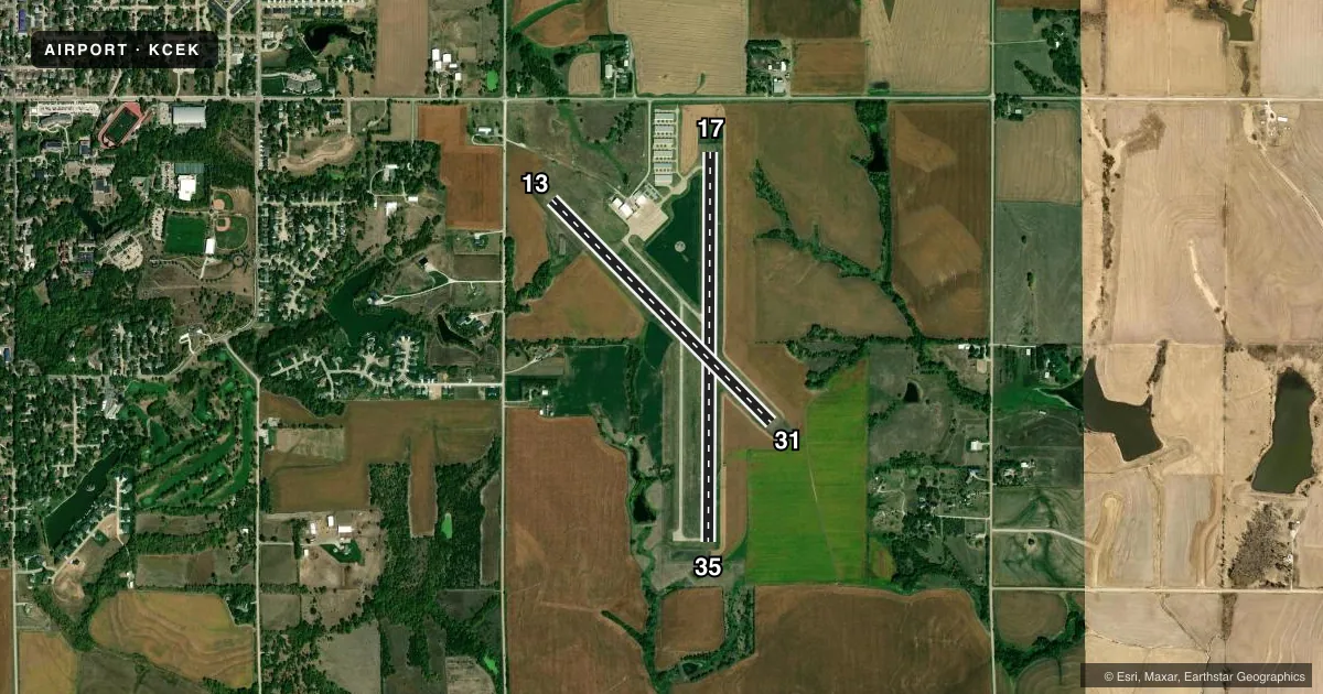
Runways & pattern
Full pagePattern entry · RWY 35
LEFT TRAFFIC| Runway | Heading (°M) | Length | Surface | Traffic |
|---|---|---|---|---|
| 17/35Favored | 175° / 355° | 4,201 ft | CONC | Standard L |
| 13/31 | 130° / 310° | 3,370 ft | TURF | Standard L |
Runway end performance
| End | TORA | TODA | ASDA | LDA | VGSI | Approach lights | Obstruction |
|---|---|---|---|---|---|---|---|
| 17 | — | — | — | — | PAPI 2-box left(3°) | — | — |
| 35 | — | — | — | — | PAPI 2-box left(3°) | — | — |
Declared distances in feet. TORA = takeoff run available, TODA = takeoff distance, ASDA = accelerate-stop, LDA = landing distance.
Airport sketch
Runways drawn to scale from FAA survey coordinates, rendered over satellite imagery. Not for navigation.
Approaches & charts
Services on the field
Fuel grades, oxygen, maintenance, ramp storage and lighting — as declared to the FAA by the airport operator.
Fuel & services
- Fuel
- 100LLA
- Oxygen (bottled)
- HIGH/LOW
- Oxygen (bulk)
- Not available
- Airframe repair
- Major
- Power plant repair
- Major
- Other services
- AMB,AVNCS,INSTR,RNTL
Ramp & ground
- Transient storage
- Tie-down
- Hangar
- Landing fee
- No fee published
- Customs
- Not available
- Lighting schedule
- SS-SR
- Beacon schedule
- SS-SR
- Beacon
- White / Green (civil land)(WG)
- Wind indicator
- Lighted
- Segmented circle
- Yes
Fuel & FBOs
Cheapest 100LL and Jet A on the field and nearby. Always confirm with the FBO before taxi.
Airport notes
Surface conditions, obstructions, local procedures, lighting outages and other notes published with each FAA cycle.
General notes
- FOR CD CTC OMAHA APCH AT 402-682-4395.
Fuel notes
- 100LLFOR SVC AFT HRS 402-314-0887.
Approach & departure obstructions
- 17RY 17 PAPI UNUSBL BYD 8 DEGS LEFT OF CNTRLN.
Other notes
- OWNERCITY OF CRETE, NEBRASKA
- OWNERBLAINE SPANJER, ACTING CHMN ADVISORY BOARD, PHONE 402-440-3153.
- AVNCSAVIONICS MAINT SVC PHONE NR: 402-710-0128.
VFR map & nearby airports
VFR sectional. Tap any ICAO chip to open that airport.
Key facts · KCEK
Answer card- ICAO
- KCEK
- Name
- CRETE MUNI
- Location
- CRETE, NEBRASKA
- Elevation
- 1,499.5 ft MSL
- Traffic pattern altitude
- 2,499.5 ft MSL (1,000 AGL)
- Control tower
- Non-towered (use CTAF)
- Total runways
- 2
- Longest runway
- 17/35 · 4,201 ft
- Published ILS approaches
- 0
- Published frequencies
- 4
- Magnetic variation
- 5°
- Current flight rules
- MVFR
- Current wind
- 040° at 8 kt
- Favored runway now
- RWY 35
Crete Muni sits in Crete, Nebraska. Field elevation is 1,499.5 ft MSL. The airport has two runways. The longest is 4,201 ft on runway 17/35, which is concrete. Runway 13/31 is 3,370 ft of turf. There is no control tower. Omaha Approach handles clearance delivery and approach or departure services. No ILS approaches are published here.
Pattern altitude is not published. For light piston traffic, plan on the standard 1,000 ft AGL unless the current Chart Supplement says otherwise. The field has a magnetic variation of 5°. Crete Fuel is on the field. It carries 100LL and Jet A Prist. Call the FBO directly for current service details. After-hours fuel service is listed in the remarks, so verify the current contact number before you go.
One published note matters on final. Runway 17 PAPI is unusable beyond 8 degrees left of centerline. That is worth keeping in mind if you are coming in from the south or setting up a stabilized approach. The airport remarks also note limited student use. Students must provide their own airplane. If you need clearance or want current operating details, use the current FAA Chart Supplement or call the airport operator or FBO directly. This is a non-towered field with a mix of turf and pavement, so expect local traffic and self-announce on CTAF 122.8.