METAR & TAF KJYR
Current METAR
Observed 15:55Z
KJYR 271555Z AUTO 31003KT 10SM CLR 31/24 A2979 RMK AO2
- Wind
- 310° @ 3 kt
- Visibility
- 10 SM
- Temp / Dew
- 31°C / 24°C
- Altimeter
- 29.79 inHg
- Clouds
- CLR
- Density alt
- 4,152 ft
- Ceiling
- Unlimited
- Rules
- VFR
Airport info & contacts
Manager on record, flight service, ARTCC, attendance schedule and pattern altitude — published by the FAA and refreshed every 28 days.
Location
- From city
- 1 NM NW
- VFR sectional
- OMAHA
- ARTCC
- ZMP · MINNEAPOLIS
- NOTAM facility
- JYR (NOTAM-D)
Airport manager
- Name
- RANDY HALL
- Phone
- 402-366-5876
- Address
- 1112 HWY 34, YORK NE 68467-3512
Flight service · Hours
- FSS OLU
- COLUMBUS1-800-WX-BRIEF
- Attendance
- 0700-1700
Frequencies
Tap any row to copy the frequency to your clipboard.
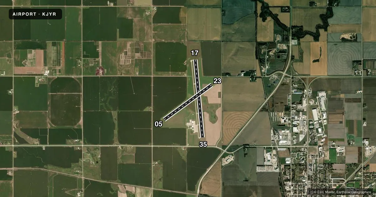
Runways & pattern
Full pagePattern entry · RWY 35
LEFT TRAFFIC| Runway | Heading (°M) | Length | Surface | Traffic |
|---|---|---|---|---|
| 17/35Favored | 169° / 349° | 5,900 ft | CONC | Standard L |
| 05/23 | 48° / 228° | 4,481 ft | TURF | Standard L |
Runway end performance
| End | TORA | TODA | ASDA | LDA | VGSI | Approach lights | Obstruction |
|---|---|---|---|---|---|---|---|
| 17 | 5,900' | 5,900' | 5,500' | 5,900' | PAPI 2-box left(3°) | — | 46', pole, 1437' from thr, 172' R of cntrln, slope 27 |
| 35 | 5,900' | 5,900' | 5,900' | 5,500' | PAPI 2-box left(3°) | — | 12', road, 620' from thr, 0' R of cntrln, slope 35 |
| 05 | — | — | — | — | — | — | 50', pole, 1004' from thr, 219' R of cntrln, slope 20 |
| 23 | — | — | — | — | — | — | 40', pline, 829' from thr, 113' R of cntrln, slope 20 |
Declared distances in feet. TORA = takeoff run available, TODA = takeoff distance, ASDA = accelerate-stop, LDA = landing distance.
Airport sketch
Runways drawn to scale from FAA survey coordinates, rendered over satellite imagery. Not for navigation.
Approaches & charts
Services on the field
Fuel grades, oxygen, maintenance, ramp storage and lighting — as declared to the FAA by the airport operator.
Fuel & services
- Fuel
- 100LLA
- Airframe repair
- Minor
- Power plant repair
- Minor
- Other services
- AGRI
Ramp & ground
- Transient storage
- Tie-down
- Hangar
- Lighting schedule
- SEE RMK
- Beacon schedule
- SS-SR
- Beacon
- White / Green (civil land)(WG)
- Wind indicator
- Lighted
- Segmented circle
- Yes
Fuel & FBOs
Cheapest 100LL and Jet A on the field and nearby. Always confirm with the FBO before taxi.
Airport notes
Surface conditions, obstructions, local procedures, lighting outages and other notes published with each FAA cycle.
General notes
- RY 35 DESIGNATED AS CALM WIND RY.
- FOR CD CTC MINNEAPOLIS ARTCC AT 651-463-5588.
Lighting notes
- ACTVT REIL RWY 17 & 35; PAPI RWY 17 & 35; MIRL RWY 17/35 - CTAF.
Runway surface & condition
- 05/23NOT PLOWED WINTER MONTHS.
Approach & departure obstructions
- 17RWY 35 APCH SLOPE 50:1 DUE TO 12 FT ROAD 1020 FT FROM DSPLCD THLD.
- 05RWY 05 CNTR PIVOT ROTATES INTO APCH DURING IRRIGATION SEASON.
Other notes
- DETERMINATION PENDING.
- 1FOR SVC AFTER HRS CALL (402) 366-5876
- MANAGERRANDY HALL AIRPORT OPS MANAGER
VFR map & nearby airports
VFR sectional. Tap any ICAO chip to open that airport.
Key facts · KJYR
Answer card- ICAO
- KJYR
- Name
- YORK MUNI
- Location
- YORK, NEBRASKA
- Elevation
- 1,669.7 ft MSL
- Traffic pattern altitude
- 2,669.7 ft MSL (1,000 AGL)
- Control tower
- Non-towered (use CTAF)
- Total runways
- 2
- Longest runway
- 17/35 · 5,900 ft
- Published ILS approaches
- 0
- Published frequencies
- 2
- Magnetic variation
- 6°
- Current flight rules
- VFR
- Current wind
- 310° at 3 kt
- Favored runway now
- RWY 35
York Muni sits in York, Nebraska. The field elevation is 1,669.7 ft MSL. It has two runways. The longest is 5,900 ft concrete runway 17/35. Runway 05/23 is 4,481 ft turf. There is no control tower. CTAF and UNICOM are both 122.8.
No ILS approaches are published here. The pattern altitude is not published, so use the standard 1,000 ft AGL for light piston operations unless the current FAA Chart Supplement says otherwise. The on-field FBO is York Municipal Airport. It carries 100LL and Jet A. Call (402) 363-2660 for current service details.
A few local items matter on the first visit. Runway 35 is the calm wind runway. Runway end identifier lights, PAPI and medium intensity runway lights are installed on runways 17 and 35. The center pivot can rotate into the approach for runway 05 during irrigation season. Runway 05/23 is not plowed in winter. For clearance delivery, contact Minneapolis ARTCC at 651-463-5588. If you need after-hours service, call (402) 366-5876. The airport sits in open country at moderate elevation. Expect normal central Nebraska wind and density altitude planning on warm days.