METAR & TAF 07K
07K does not publish a METAR.
Showing the nearest reporting station: KAUH (AURORA MUNI/AL POTTER FLD) · 13.3 NM away. Conditions at 07K may differ.
METAR · KAUH
Observed 12:35Z
KAUH 271235Z AUTO 00000KT 10SM CLR 25/22 A2979 RMK AO2 T02500216
- Wind
- 000° @ 0 kt
- Visibility
- 10 SM
- Temp / Dew
- 25°C / 22°C
- Altimeter
- 29.79 inHg
- Clouds
- CLR
- Density alt
- 3,490 ft
- Ceiling
- Unlimited
- Rules
- VFR
Airport info & contacts
Manager on record, flight service, ARTCC, attendance schedule and pattern altitude — published by the FAA and refreshed every 28 days.
Location
- From city
- 3 NM W
- VFR sectional
- OMAHA
- ARTCC
- ZMP · MINNEAPOLIS
- NOTAM facility
- OLU (NOTAM-D)
Airport manager
- Name
- CHIP COSLOR
- Phone
- 308-946-3450
- Address
- 1346 ORMSBY N RD, CENTRAL CITY NE 68826-8009
Flight service · Hours
- FSS OLU
- COLUMBUS1-800-WX-BRIEF
- Attendance
- MON-FRI · 0800-1700
Frequencies
Tap any row to copy the frequency to your clipboard.
Runways & pattern
Full pagePattern entry · RWY 16
LEFT TRAFFICRunway end performance
| End | TORA | TODA | ASDA | LDA | VGSI | Approach lights | Obstruction |
|---|---|---|---|---|---|---|---|
| 16 | — | — | — | — | PAPI 2-box left(3°) | — | — |
| 34 | — | — | — | — | PAPI 2-box left(3°) | — | — |
Declared distances in feet. TORA = takeoff run available, TODA = takeoff distance, ASDA = accelerate-stop, LDA = landing distance.
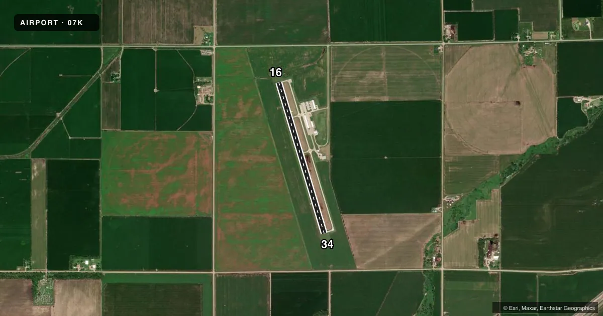
Airport sketch
Runways drawn to scale from FAA survey coordinates, rendered over satellite imagery. Not for navigation.
Approaches & charts
Services on the field
Fuel grades, oxygen, maintenance, ramp storage and lighting — as declared to the FAA by the airport operator.
Fuel & services
- Fuel
- 100LL
- Oxygen (bottled)
- Not available
- Oxygen (bulk)
- Not available
- Airframe repair
- Major
- Power plant repair
- Major
- Other services
- AGRI,INSTR,RNTL
Ramp & ground
- Transient storage
- Tie-down
- Hangar
- Landing fee
- No fee published
- Customs
- Not available
- Lighting schedule
- SEE RMK
- Beacon schedule
- SS-SR
- Beacon
- White / Green (civil land)(WG)
- Wind indicator
- Lighted
- Segmented circle
- No
Fuel & FBOs
Cheapest 100LL and Jet A on the field and nearby. Always confirm with the FBO before taxi.
Airport notes
Surface conditions, obstructions, local procedures, lighting outages and other notes published with each FAA cycle.
General notes
- (E81) TURN-OFF ONLY.
- ROTG BCN & LGTD WIND SOCK ON SS-SR.
- FOR CD CTC MINNEAPOLIS ARTCC AT 651-463-5588.
Lighting notes
- ACTVT PAPI RWY 16/34; MIRL RWY 16/34 - CTAF.
Fuel notes
- 100LLFOR FUEL AFT HRS CALL POLICE 308-946-3003.
Approach & departure obstructions
- 16POLE-PWR EXTENDS ACRS THE WHOLE APCH.
Other notes
- CALL FOR HANGAR AVBL 308-946-3806.
VFR map & nearby airports
VFR sectional. Tap any ICAO chip to open that airport.
Key facts · 07K
Answer card- ICAO
- 07K
- Name
- CENTRAL CITY MUNI/LARRY REINEKE FLD
- Location
- CENTRAL CITY, NEBRASKA
- Elevation
- 1,716.7 ft MSL
- Traffic pattern altitude
- 2,716.7 ft MSL (1,000 AGL)
- Control tower
- Non-towered (use CTAF)
- Total runways
- 1
- Longest runway
- 16/34 · 3,700 ft
- Published ILS approaches
- 0
- Published frequencies
- 1
- Magnetic variation
- 5°
- Current flight rules
- VFR
- Current wind
- 000° at 0 kt
- Favored runway now
- –
Central City Muni/Larry Reineke Fld (07K) sits in Central City, Nebraska. Field elevation is 1,716.7 ft MSL. The airport has one runway. Runway 16/34 is 3,700 ft long with a concrete surface. There is no control tower. CTAF is 122.9.
No ILS approaches are published here. Pattern altitude is not published in the facts, so use the standard 1,000 ft AGL for light piston operations unless the current FAA Chart Supplement says otherwise. The field has one on-field FBO. Central Nebraska Airmotive is on the field. It carries 100LL. Call (308) 946-3450 before arrival if you need fuel or current service details.
A few published remarks matter for planning. A power pole extends across the whole approach to runway 16. That makes the 16 end a runway to study closely before you commit. The PAPI and medium intensity runway lights on 16/34 are activated by using the CTAF. The rotating beacon and lighted wind sock operate from sunset to sunrise. For after-hours 100LL, the published note says to call police at (308) 946-3003. This is a non-towered field with a single runway and a modest elevation above sea level. Brief on CTAF. Watch your approach path. Verify current field status before you go.