METAR & TAF KGRI
Current METAR
Observed 12:53Z
KGRI 271253Z 26003KT 10SM CLR 27/21 A2980 RMK AO2 SLP073 T02670211
- Wind
- 260° @ 3 kt
- Visibility
- 10 SM
- Temp / Dew
- 27°C / 21°C
- Altimeter
- 29.80 inHg
- Clouds
- CLR
- Density alt
- 3,879 ft
- Ceiling
- Unlimited
- Rules
- VFR
Airport info & contacts
Manager on record, flight service, ARTCC, attendance schedule and pattern altitude — published by the FAA and refreshed every 28 days.
Location
- From city
- 3 NM NE
- VFR sectional
- OMAHA
- ARTCC
- ZMP · MINNEAPOLIS
- NOTAM facility
- GRI (NOTAM-D)
Airport manager
- Name
- MR. MICHAEL OLSON, A.A.E.
- Phone
- 308-385-5170
- Address
- 3855 SKY PARK ROAD, GRAND ISLAND NE 68801
Flight service · Hours
- FSS OLU
- COLUMBUS1-800-WX-BRIEF
- Attendance
- ALL
Frequencies
Tap any row to copy the frequency to your clipboard.
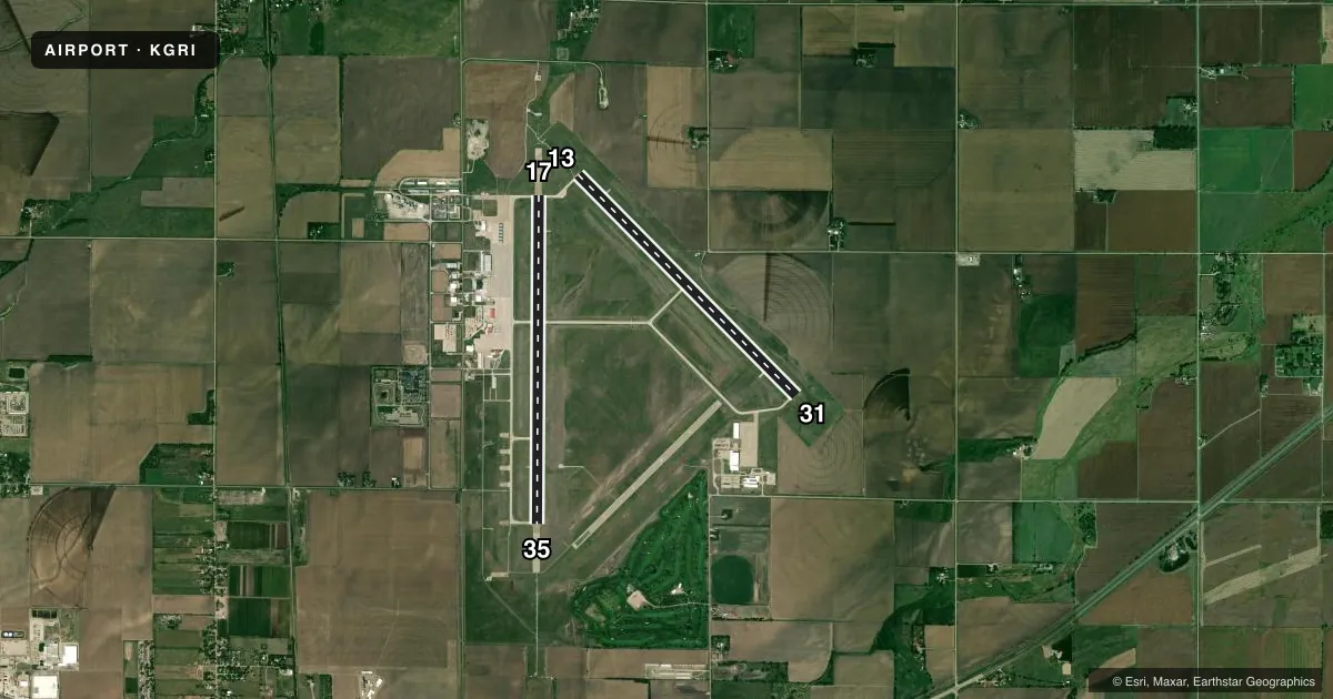
Runways & pattern
Full pagePattern entry · RWY 31
LEFT TRAFFIC| Runway | Heading (°M) | Length | Surface | Traffic |
|---|---|---|---|---|
| 17/35 | 173° / 353° | 7,002 ft | CONC | Standard L |
| 13/31Favored | 128° / 308° | 6,608 ft | CONC | Standard L |
Runway end performance
| End | TORA | TODA | ASDA | LDA | VGSI | Approach lights | Obstruction |
|---|---|---|---|---|---|---|---|
| 17 | 7,002' | 7,002' | 7,002' | 7,002' | PAPI 4-box left(3°) | MALS | — |
| 35 | 7,002' | 7,002' | 7,002' | 7,002' | PAPI 4-box left(2.6°) | MALSR | — |
| 13 | 6,608' | 6,608' | 6,608' | 6,608' | PAPI 4-box left(3°) | MALS | — |
| 31 | 6,608' | 6,608' | 6,608' | 6,608' | PAPI 4-box left(3°) | — | — |
Declared distances in feet. TORA = takeoff run available, TODA = takeoff distance, ASDA = accelerate-stop, LDA = landing distance.
Airport sketch
Runways drawn to scale from FAA survey coordinates, rendered over satellite imagery. Not for navigation.
Approaches & charts
ILS · 1
Services on the field
Fuel grades, oxygen, maintenance, ramp storage and lighting — as declared to the FAA by the airport operator.
Fuel & services
- Fuel
- 100LLA
- Oxygen (bottled)
- Not available
- Oxygen (bulk)
- HIGH/LOW
- Airframe repair
- Major
- Power plant repair
- Major
- Other services
- AFRT,AMB,AVNCS,CARGO,CHTR,INSTR
Ramp & ground
- Transient storage
- Tie-down
- Hangar
- Landing fee
- No fee published
- Customs
- Not available
- Lighting schedule
- SEE RMK
- Beacon schedule
- SS-SR
- Beacon
- White / Green (civil land)(WG)
- Wind indicator
- Lighted
- Segmented circle
- No
Fuel & FBOs
Cheapest 100LL and Jet A on the field and nearby. Always confirm with the FBO before taxi.
Airport notes
Surface conditions, obstructions, local procedures, lighting outages and other notes published with each FAA cycle.
General notes
- COMPRESSED NITROGEN FOR STRUT INFLATION AVBL.
- INBOUND ACFT CTC OPS 10 MIN PRIOR TO LNDG.
- ARNG: OPR 0730-1600++MON-FRI; OCNL WKEND. PPR TO PRK ARNG RAMP. DSN 279-8691, C402-309-8691.
- MIGRATORY WATERFOWL ON & INVOF ARPT.
- TWY DELTA EXIT OFF RY 17/35 CLSD TO LARGE ACFT DUE TO INADEQUATE TURNING RADIUS.
Lighting notes
- ACTVT PAPI RWY 31 & 35 - CTAF. WHEN TWR CLSD ACTVT MALS RWY 13 & 17; MALSR RWY 35; REIL RWY 31; PAPI RWY 13 & 17; MIRL RWY 13/31; HIRL RWY 17/35 - CTAF.
Runway surface & condition
- 13/31PCR VALUE: 180/R/D/W/T
- 17/35PCR VALUE: 450/R/D/W/T
Approach & departure obstructions
- 35PAPI RESTRICTED BYD 6 DEG RIGHT OF CNTRL.
Other notes
- THIS AIRPORT HAS BEEN SURVEYED BY THE NATIONAL GEODETIC SURVEY.
- PPR 24 HRS FOR UNSKED ACR OPNS WITH MORE THAN 30 PSGR SEATS CALL AMGR (308) 385-5170. INDEX C LEVEL ARFF IS AVBL UPON REQUEST. ACR OPNS OVER 9 PSGR SEATS NOT AUTHORIZED IN EXCESS OF 15 MINS BEFORE OR AFT SKED ARR/DEP TIMES EXCEPT WITH PRIOR COORDINATION WITH AMGR.
- MANAGEROR 308-385-5172.
VFR map & nearby airports
VFR sectional. Tap any ICAO chip to open that airport.
Key facts · KGRI
Answer card- ICAO
- KGRI
- Name
- CENTRAL NEBRASKA RGNL
- Location
- GRAND ISLAND, NEBRASKA
- Elevation
- 1,847.1 ft MSL
- Traffic pattern altitude
- 2,847.1 ft MSL (1,000 AGL)
- Control tower
- Towered · 0700-2000
- Total runways
- 2
- Longest runway
- 17/35 · 7,002 ft
- Published ILS approaches
- 1
- Published frequencies
- 8
- Magnetic variation
- 7°
- Current flight rules
- VFR
- Current wind
- 260° at 3 kt
- Favored runway now
- RWY 31
Central Nebraska Rgnl is in Grand Island, Nebraska. The field elevation is 1,847.1 ft MSL. It has two concrete runways. The longest is 17/35 at 7,002 ft. The airport is towered from 0700 to 2000. Runway 35 has the ILS. Pattern altitude is not published, so use the standard 1,000 ft AGL unless the current Chart Supplement says otherwise. That puts the light piston pattern at about 2,847 ft MSL.
Trego-Dugan Aviation is on the field. It carries 100LL and Jet A Prist. Call ahead if you need ramp or fuel coordination. Published remarks say parking arrangements are available Monday through Friday from 0730 to 1600, with occasional weekend availability. Prior permission is required for the arranging ramp. Inbound aircraft must contact operations 10 minutes before landing. Large aircraft should also note the taxiway Delta exit off runway 17/35 is closed to large aircraft because of turning radius limits.
This is a busy controlled field with published lighting procedures that matter after hours. The airport also notes migratory waterfowl in and around the field. That is worth planning for on departure and arrival. If you are bringing a larger aircraft, check the current Chart Supplement and call the airport operator before you go. The remarks also mention passenger-seat restrictions and prior coordination for some unscheduled operations.