METAR & TAF KEAR
Current METAR
Observed 05:56Z
KEAR 270556Z AUTO 19010KT 10SM CLR 29/21 A2981 RMK AO2 SLP065 T02940206 10378 20278 403830228 50005
- Wind
- 190° @ 10 kt
- Visibility
- 10 SM
- Temp / Dew
- 29°C / 21°C
- Altimeter
- 29.81 inHg
- Clouds
- CLR
- Density alt
- 4,460 ft
- Ceiling
- Unlimited
- Rules
- VFR
Airport info & contacts
Manager on record, flight service, ARTCC, attendance schedule and pattern altitude — published by the FAA and refreshed every 28 days.
Location
- From city
- 4 NM NE
- VFR sectional
- OMAHA
- ARTCC
- ZMP · MINNEAPOLIS
- NOTAM facility
- EAR (NOTAM-D)
Airport manager
- Name
- JAMES LYNAUGH
- Phone
- 308-234-2318
- Address
- P.O. BOX 1180, KEARNEY NE 68848
Flight service · Hours
- FSS OLU
- COLUMBUS1-800-WX-BRIEF
- Attendance
- 0600-2000
Frequencies
Tap any row to copy the frequency to your clipboard.
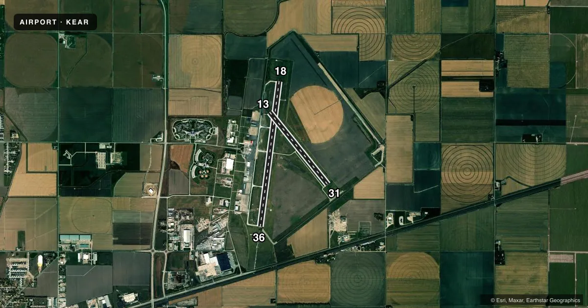
Runways & pattern
Full pagePattern entry · RWY 18
LEFT TRAFFIC| Runway | Heading (°M) | Length | Surface | Traffic |
|---|---|---|---|---|
| 18/36Favored | 182° / 2° | 7,094 ft | CONC | Standard L |
| 13/31 | 136° / 316° | 4,498 ft | CONC | Standard L |
Runway end performance
| End | TORA | TODA | ASDA | LDA | VGSI | Approach lights | Obstruction |
|---|---|---|---|---|---|---|---|
| 18 | 7,094' | 7,094' | 7,094' | 7,094' | PAPI 4-box left(3°) | — | 103', bldg, 5250' from thr, 0' R of cntrln, slope 49 |
| 36 | 7,094' | 7,094' | 7,094' | 7,094' | PAPI 4-box left(3°) | MALSR | — |
| 13 | 4,498' | 4,498' | 4,498' | 4,498' | PAPI 2-box left(3°) | — | — |
| 31 | 4,498' | 4,498' | 4,498' | 4,498' | PAPI 2-box left(3°) | — | — |
Declared distances in feet. TORA = takeoff run available, TODA = takeoff distance, ASDA = accelerate-stop, LDA = landing distance.
Airport sketch
Runways drawn to scale from FAA survey coordinates, rendered over satellite imagery. Not for navigation.
Approaches & charts
ILS · 1
Services on the field
Fuel grades, oxygen, maintenance, ramp storage and lighting — as declared to the FAA by the airport operator.
Fuel & services
- Fuel
- 100LLA
- Oxygen (bottled)
- Not available
- Oxygen (bulk)
- Not available
- Airframe repair
- Major
- Power plant repair
- Major
- Other services
- AFRT,AGRI,AMB,CHTR,INSTR,RNTL,SALES
Ramp & ground
- Transient storage
- Tie-down
- Hangar
- Landing fee
- No fee published
- Customs
- Not available
- Lighting schedule
- SEE RMK
- Beacon schedule
- SS-SR
- Beacon
- White / Green (civil land)(WG)
- Wind indicator
- Lighted
- Segmented circle
- Yes
Fuel & FBOs
Cheapest 100LL and Jet A on the field and nearby. Always confirm with the FBO before taxi.
Airport notes
Surface conditions, obstructions, local procedures, lighting outages and other notes published with each FAA cycle.
General notes
- BE ALERT WHEN TAXIING ON APRON DUE TO SEVERAL CLOSED AREAS.
- AIR CARRIER OPS ARE NOT AUTHORIZED IN EXCESS OF 15 MINUTES BEFORE OR AFTER SCHEDULED ARRIVAL/DEPARTURE TIMES WITHOUT PRIOR COORDINATION WITH AMGR AND CONFIRMATION THAT ARFF IS AVBL PRIOR TO LDNG OR TKOF.
- FOR CD IF UNA TO CTC ON FSS FREQ, CTC MINNEAPOLIS ARTCC AT 651-463-5588.
Lighting notes
- HIRL RWY 18/36 PRESET ON LOW INTST; TO INCR INTST & ACTVT REIL RWY 18; MALSR RWY 36; PAPI RWYS 13, 18, 31, & 36; AND MIRL RWY 13/31 - CTAF.
Runway surface & condition
- 13/31PCR VALUE: 90/R/C/W/T
- 18/36PCR VALUE: 155/R/C/W/T
Other notes
- ARFF INDEX B EQUIPMENT PROVIDED. PPR 48 HRS FOR AIR CARRIER OPS WITH MORE THAN 30 PASSENGER SEATS. CALL ARPT MGR 308-234-2318 OR 308-440-6069.
VFR map & nearby airports
VFR sectional. Tap any ICAO chip to open that airport.
Key facts · KEAR
Answer card- ICAO
- KEAR
- Name
- KEARNEY RGNL
- Location
- KEARNEY, NEBRASKA
- Elevation
- 2,131.8 ft MSL
- Traffic pattern altitude
- 3,131.8 ft MSL (1,000 AGL)
- Control tower
- Non-towered (use CTAF)
- Total runways
- 2
- Longest runway
- 18/36 · 7,094 ft
- Published ILS approaches
- 1
- Published frequencies
- 2
- Magnetic variation
- 5°
- Current flight rules
- VFR
- Current wind
- 190° at 10 kt
- Favored runway now
- RWY 18
Kearney Regional Airport sits in Kearney, Nebraska. The field elevation is 2,131.8 ft MSL. It has two concrete runways. The longest is 18/36 at 7,094 ft. There is no control tower, so use CTAF 123.0 for local traffic and lighting control. The airport has one ILS approach to runway 36. Pattern altitude is not published. Use the standard 1,000 ft AGL for light piston operations unless the current FAA Chart Supplement says otherwise.
Kearney Flight Services is on the field. It carries 100LL and Jet A. Call ahead at (308) 234-4072 if you need current ramp or fuel details. The published remarks also matter here. Runway lights on 18/36 start at low intensity. Use the CTAF to raise intensity and to activate the approach lighting and runway end identifier lights where published. The apron has several closed areas, so taxi with care. This is a higher-elevation Nebraska field, so expect the usual density altitude planning on warm days. The airport also publishes ARFF index B equipment. For air carrier operations, there are coordination and notice requirements in the remarks. Check the current FAA Chart Supplement before arrival if you need the latest operational details.