METAR & TAF KLXN
Current METAR
Observed 13:35Z
KLXN 271335Z AUTO 00000KT 10SM CLR 27/24 A2987 RMK AO2 T02690243
- Wind
- 000° @ 0 kt
- Visibility
- 10 SM
- Temp / Dew
- 27°C / 24°C
- Altimeter
- 29.87 inHg
- Clouds
- CLR
- Density alt
- 4,494 ft
- Ceiling
- Unlimited
- Rules
- VFR
Airport info & contacts
Manager on record, flight service, ARTCC, attendance schedule and pattern altitude — published by the FAA and refreshed every 28 days.
Location
- From city
- 2 NM NW
- VFR sectional
- OMAHA
- ARTCC
- ZDV · DENVER
- NOTAM facility
- LXN (NOTAM-D)
Airport manager
- Name
- NATHAN MASTEN
- Phone
- 308-324-8770
- Address
- 1501 NORTH AIRPORT ROAD, LEXINGTON NE 68850-3471
Flight service · Hours
- FSS OLU
- COLUMBUS1-800-WX-BRIEF
- Attendance
- MON-FRI · 0800-1700
- SAT · 0800-1200
Frequencies
Tap any row to copy the frequency to your clipboard.
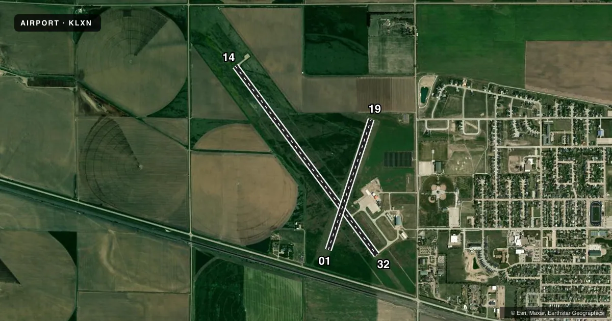
Runways & pattern
Full pagePattern entry · RWY 14
LEFT TRAFFIC| Runway | Heading (°M) | Length | Surface | Traffic |
|---|---|---|---|---|
| 14/32 | 136° / 316° | 5,489 ft | CONC | Standard L |
| 01/19 | 11° / 191° | 3,200 ft | TURF | Standard L |
Runway end performance
| End | TORA | TODA | ASDA | LDA | VGSI | Approach lights | Obstruction |
|---|---|---|---|---|---|---|---|
| 14 | — | — | — | — | PAPI 2-box left(3°) | — | — |
| 32 | — | — | — | — | PAPI 2-box left(3°) | — | — |
Declared distances in feet. TORA = takeoff run available, TODA = takeoff distance, ASDA = accelerate-stop, LDA = landing distance.
Airport sketch
Runways drawn to scale from FAA survey coordinates, rendered over satellite imagery. Not for navigation.
Approaches & charts
Services on the field
Fuel grades, oxygen, maintenance, ramp storage and lighting — as declared to the FAA by the airport operator.
Fuel & services
- Fuel
- 100LLA+
- Oxygen (bottled)
- Not available
- Oxygen (bulk)
- Not available
- Airframe repair
- Major
- Power plant repair
- Major
- Other services
- AGRI
Ramp & ground
- Transient storage
- Tie-down
- Hangar
- Landing fee
- No fee published
- Customs
- Not available
- Lighting schedule
- SEE RMK
- Beacon schedule
- SS-SR
- Beacon
- White / Green (civil land)(WG)
- Wind indicator
- Yes
- Segmented circle
- No
Fuel & FBOs
Cheapest 100LL and Jet A on the field and nearby. Always confirm with the FBO before taxi.
Airport notes
Surface conditions, obstructions, local procedures, lighting outages and other notes published with each FAA cycle.
General notes
- RY 01/19 NOT PLOWED WINTER MONTHS.
- FOR CD CTC DENVER ARTCC AT 303-651-4257.
Lighting notes
- ACTVT REIL RY 14/32; MIRL RY 14/32; PAPI RYS 14/32 - CTAF.
Fuel notes
- A+SELF SVC FUEL AVBL 24 HRS WITH CREDIT CARD.
Approach & departure obstructions
- 19CROPS MAY BE CTLG OBS DURING GROWING SEASON IN THE APCH.
VFR map & nearby airports
VFR sectional. Tap any ICAO chip to open that airport.
Key facts · KLXN
Answer card- ICAO
- KLXN
- Name
- JIM KELLY FLD
- Location
- LEXINGTON, NEBRASKA
- Elevation
- 2,412.6 ft MSL
- Traffic pattern altitude
- 3,412.6 ft MSL (1,000 AGL)
- Control tower
- Non-towered (use CTAF)
- Total runways
- 2
- Longest runway
- 14/32 · 5,489 ft
- Published ILS approaches
- 0
- Published frequencies
- 2
- Magnetic variation
- 7°
- Current flight rules
- VFR
- Current wind
- 000° at 0 kt
- Favored runway now
- –
JIM KELLY FLD sits in Lexington, Nebraska. Field elevation is 2,412.6 ft MSL. The airport has two runways. The longest is 14/32 at 5,489 ft on concrete. Runway 01/19 is 3,200 ft on turf. There is no control tower. CTAF and UNICOM are both 123.0. No ILS approaches are published, so plan with that in mind if the weather is moving in.
Pattern altitude is not published. Use the standard 1,000 ft AGL for light piston operations unless the current Chart Supplement says otherwise. The on-field FBO is Lexington Airport Autority. It carries 100LL and Jet A. Self-serve fuel is available 24 hours with a credit card. Runway 14/32 has REIL, medium intensity runway lighting and PAPI on both runways. The lights are activated on CTAF.
For a first-time arrival, the big things are the field elevation and the runway setup. Density altitude can matter here in warm weather. Runway 01/19 is not plowed during winter months. Crops may also show up as obstacles in the approach during the growing season. For clearance delivery, contact Denver ARTCC at 303-651-4257 before departure if you need IFR release or other coordination.