METAR & TAF KCSB
Current METAR
Observed 13:15Z
KCSB 271315Z AUTO 01005KT 10SM CLR 28/23 A2983 RMK AO2
- Wind
- 010° @ 5 kt
- Visibility
- 10 SM
- Temp / Dew
- 28°C / 23°C
- Altimeter
- 29.83 inHg
- Clouds
- CLR
- Density alt
- 4,665 ft
- Ceiling
- Unlimited
- Rules
- VFR
Airport info & contacts
Manager on record, flight service, ARTCC, attendance schedule and pattern altitude — published by the FAA and refreshed every 28 days.
Location
- From city
- 2 NM NE
- VFR sectional
- OMAHA
- ARTCC
- ZDV · DENVER
- NOTAM facility
- OLU (NOTAM-D)
Airport manager
- Name
- GOLDEN PLAINS AVIAT / WESLEY HOCK
- Phone
- 308-697-8624
- Address
- 72279 ROAD 410, CAMBRIDGE NE 69022-3606
Flight service · Hours
- FSS OLU
- COLUMBUS1-800-WX-BRIEF
- Attendance
- MON-SAT · 0800-1800
Frequencies
Tap any row to copy the frequency to your clipboard.
Runways & pattern
Full pagePattern entry · RWY 33
LEFT TRAFFICRunway end performance
| End | TORA | TODA | ASDA | LDA | VGSI | Approach lights | Obstruction |
|---|---|---|---|---|---|---|---|
| 15 | — | — | — | — | PAPI 2-box left(3°) | — | — |
| 33 | — | — | — | — | PAPI 2-box left(3°) | — | — |
Declared distances in feet. TORA = takeoff run available, TODA = takeoff distance, ASDA = accelerate-stop, LDA = landing distance.
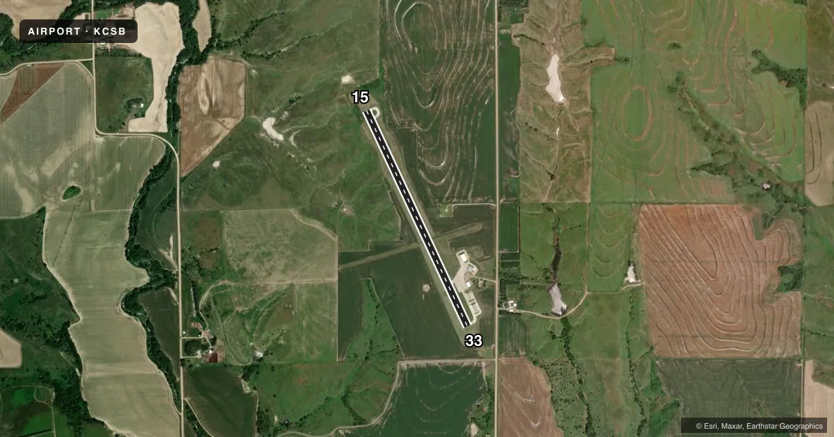
Airport sketch
Runways drawn to scale from FAA survey coordinates, rendered over satellite imagery. Not for navigation.
Approaches & charts
Services on the field
Fuel grades, oxygen, maintenance, ramp storage and lighting — as declared to the FAA by the airport operator.
Fuel & services
- Fuel
- Not available
- Oxygen (bottled)
- Not available
- Oxygen (bulk)
- Not available
- Airframe repair
- Major
- Power plant repair
- Major
- Other services
- AGRI
Ramp & ground
- Transient storage
- Tie-down
- Hangar
- Landing fee
- No fee published
- Customs
- Not available
- Lighting schedule
- SEE RMK
- Beacon schedule
- SS-SR
- Beacon
- White / Green (civil land)(WG)
- Wind indicator
- Lighted
- Segmented circle
- Yes
Fuel & FBOs
Cheapest 100LL and Jet A on the field and nearby. Always confirm with the FBO before taxi.
Airport notes
Surface conditions, obstructions, local procedures, lighting outages and other notes published with each FAA cycle.
General notes
- FOR CD CTC DENVER ARTCC AT 303-651-4257.
Lighting notes
- MIRL RY 15/33 PRESET ON LOW INTST; TO INCR INTST & ACTVT PAPI RYS 15 & 33 - CTAF.
Other notes
- CALL AHD TO AMGR TO ARNG TRANSIENT HNGR SPACE.
VFR map & nearby airports
VFR sectional. Tap any ICAO chip to open that airport.
Key facts · KCSB
Answer card- ICAO
- KCSB
- Name
- CAMBRIDGE MUNI
- Location
- CAMBRIDGE, NEBRASKA
- Elevation
- 2,414.2 ft MSL
- Traffic pattern altitude
- 3,414.2 ft MSL (1,000 AGL)
- Control tower
- Non-towered (use CTAF)
- Total runways
- 1
- Longest runway
- 15/33 · 4,098 ft
- Published ILS approaches
- 0
- Published frequencies
- 2
- Magnetic variation
- 5°
- Current flight rules
- VFR
- Current wind
- 010° at 5 kt
- Favored runway now
- RWY 33
Cambridge Muni sits in Cambridge, Nebraska. The field elevation is 2,414.2 ft MSL. It has one runway. Runway 15/33 is 4,098 ft long with a concrete surface. No tower is published here, so plan for non-towered CTAF operations on 122.8. No ILS approaches are published for the field.
The pattern altitude is not published. Use the standard 1,000 ft AGL pattern unless the current Chart Supplement says otherwise. That puts you at about 3,414 ft MSL based on the listed field elevation. The runway lighting is set up so you can use the common traffic advisory frequency to raise intensity and turn on the precision approach path indicators for runways 15 and 33. That is useful after dark or in low light.
There are no on-field FBOs listed in the facts. Call ahead to the airport manager if you need transient hangar space. For clearance delivery, Denver Air Route Traffic Control Center is listed at 303-651-4257. If you are planning a night arrival or a first trip in, check the current Chart Supplement for any published procedures before you go. The airport sits in open country, so expect a straightforward rural arrival with normal density altitude awareness in warm weather.