METAR & TAF KNRN
Current METAR
Observed 13:35Z
KNRN 271335Z AUTO 33006KT 10SM CLR 27/18 A2984 RMK AO2
- Wind
- 330° @ 6 kt
- Visibility
- 10 SM
- Temp / Dew
- 27°C / 18°C
- Altimeter
- 29.84 inHg
- Clouds
- CLR
- Density alt
- 4,495 ft
- Ceiling
- Unlimited
- Rules
- VFR
Airport info & contacts
Manager on record, flight service, ARTCC, attendance schedule and pattern altitude — published by the FAA and refreshed every 28 days.
Location
- From city
- 1 NM N
- VFR sectional
- WICHITA
- ARTCC
- ZDV · DENVER
- NOTAM facility
- ICT (NOTAM-D)
Airport manager
- Name
- BRICE RILEY
- Phone
- 785-877-2201
- Address
- 1226 N STATE ST, PO BOX 272, NORTON KS 67654
Flight service · Hours
- FSS ICT
- WICHITA1-800-WX-BRIEF
- Attendance
- MON-FRI · 0800-1700
Frequencies
Tap any row to copy the frequency to your clipboard.
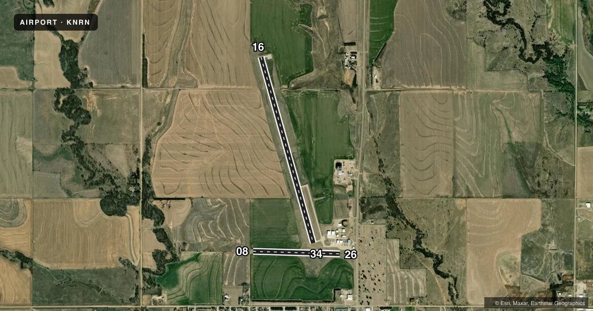
Runways & pattern
Full pagePattern entry · RWY 34
LEFT TRAFFIC| Runway | Heading (°M) | Length | Surface | Traffic |
|---|---|---|---|---|
| 16/34Favored | 157° / 337° | 4,701 ft | CONC | Standard L |
| 08/26 | 84° / 264° | 2,117 ft | TURF | Standard L |
Runway end performance
| End | TORA | TODA | ASDA | LDA | VGSI | Approach lights | Obstruction |
|---|---|---|---|---|---|---|---|
| 16 | — | — | — | — | PAPI 2-box left(3°) | — | — |
| 34 | — | — | — | — | PAPI 2-box left(3°) | — | — |
| 08 | — | — | — | — | — | — | 24', trees, 510' from thr, 85' R of cntrln, slope 21 |
Declared distances in feet. TORA = takeoff run available, TODA = takeoff distance, ASDA = accelerate-stop, LDA = landing distance.
Airport sketch
Runways drawn to scale from FAA survey coordinates, rendered over satellite imagery. Not for navigation.
Approaches & charts
Services on the field
Fuel grades, oxygen, maintenance, ramp storage and lighting — as declared to the FAA by the airport operator.
Fuel & services
- Fuel
- 100LLAA1+
- Airframe repair
- Not available
- Power plant repair
- Not available
- Other services
- AGRI
Ramp & ground
- Transient storage
- Tie-down
- Landing fee
- No fee published
- Customs
- Not available
- Beacon schedule
- SS-SR
- Beacon
- White / Green (civil land)(WG)
- Wind indicator
- Lighted
- Segmented circle
- No
Fuel & FBOs
Cheapest 100LL and Jet A on the field and nearby. Always confirm with the FBO before taxi.
Airport notes
Surface conditions, obstructions, local procedures, lighting outages and other notes published with each FAA cycle.
General notes
- FOR CD CTC DENVER ARTCC AT 303-651-4257.
- NO LINE OF SIGHT BETWEEN RWY ENDS.
Fuel notes
- AFUEL 24 HR SELF-SERVE.
Other notes
- 16/34RWY SFC ROUGH DUE TO UNEVEN PAVING JOINTS EVERY 10 FT.
- 08/26SURFACE ROUGH.
VFR map & nearby airports
VFR sectional. Tap any ICAO chip to open that airport.
Key facts · KNRN
Answer card- ICAO
- KNRN
- Name
- NORTON MUNI
- Location
- NORTON, KANSAS
- Elevation
- 2,384 ft MSL
- Traffic pattern altitude
- 3,384 ft MSL (1,000 AGL)
- Control tower
- Non-towered (use CTAF)
- Total runways
- 2
- Longest runway
- 16/34 · 4,701 ft
- Published ILS approaches
- 0
- Published frequencies
- 1
- Magnetic variation
- 8°
- Current flight rules
- VFR
- Current wind
- 330° at 6 kt
- Favored runway now
- RWY 34
Norton Muni sits in Norton, Kansas at 2,384 ft MSL. It has two runways. The longest is 16/34 at 4,701 ft on concrete. Runway 08/26 is 2,117 ft on turf. There is no control tower. CTAF is 122.9. No ILS approaches are published.
Pattern altitude is not published. Use the standard 1,000 ft AGL for light piston operations unless the current Chart Supplement says otherwise. That puts the traffic pattern at 3,384 ft MSL based on the field elevation. The airport uses 8° magnetic variation. Pilots should note the published remarks. Runway 16/34 has rough pavement with uneven joints every 10 ft. Runway 08/26 is also reported as rough. There is no line of sight between runway ends, so plan your traffic and runway checks carefully.
Norton Municipal Airport is the on-field FBO. It carries AVGAS 100LL and Jet A. Fuel is available 24 hours self-serve. For clearance delivery, contact Denver ARTCC at 303-651-4257. This is a non-towered field in open country. Expect to self-announce on CTAF and verify current runway condition before you go.