METAR & TAF 0P1
0P1 does not publish a METAR.
Showing the nearest reporting station: KPHG (PHILLIPSBURG MUNI) · 12.9 NM away. Conditions at 0P1 may differ.
METAR · KPHG
Observed 11:35Z
KPHG 271135Z AUTO 10002KT 10SM CLR 23/19 A2979 RMK AO2
- Wind
- 100° @ 2 kt
- Visibility
- 10 SM
- Temp / Dew
- 23°C / 19°C
- Altimeter
- 29.79 inHg
- Clouds
- CLR
- Density alt
- 3,865 ft
- Ceiling
- Unlimited
- Rules
- VFR
Airport info & contacts
Manager on record, flight service, ARTCC, attendance schedule and pattern altitude — published by the FAA and refreshed every 28 days.
Location
- From city
- 0 NM E
- VFR sectional
- WICHITA
- ARTCC
- ZDV · DENVER
- NOTAM facility
- ICT (NOTAM-D)
Airport manager
- Name
- ROGER VAN LOENEN
- Phone
- 785-973-2252
- Address
- BOX 404, PRAIRIE VIEW KS 67664
Flight service · Hours
- FSS ICT
- WICHITA1-800-WX-BRIEF
- Attendance
- Unattended
Frequencies
Tap any row to copy the frequency to your clipboard.
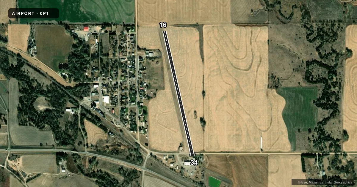
Runways & pattern
Full pagePattern entry · RWY 16
LEFT TRAFFICRunway end performance
| End | TORA | TODA | ASDA | LDA | VGSI | Approach lights | Obstruction |
|---|---|---|---|---|---|---|---|
| 16 | — | — | — | — | — | — | 6', crops, 5' from thr, 0' R of cntrln, slope 0 |
| 34 | — | — | — | — | — | — | 15', road, 15' from thr, 0' R of cntrln, slope 1 |
Declared distances in feet. TORA = takeoff run available, TODA = takeoff distance, ASDA = accelerate-stop, LDA = landing distance.
Airport sketch
Runways drawn to scale from FAA survey coordinates, rendered over satellite imagery. Not for navigation.
Approaches & charts
Services on the field
Fuel grades, oxygen, maintenance, ramp storage and lighting — as declared to the FAA by the airport operator.
Fuel & services
- Fuel
- Not available
- Oxygen (bottled)
- Not available
- Oxygen (bulk)
- Not available
- Airframe repair
- Not available
- Power plant repair
- Not available
Ramp & ground
- Transient storage
- Not published
- Landing fee
- No fee published
- Wind indicator
- Yes
- Segmented circle
- No
Fuel & FBOs
Cheapest 100LL and Jet A on the field and nearby. Always confirm with the FBO before taxi.
Airport notes
Surface conditions, obstructions, local procedures, lighting outages and other notes published with each FAA cycle.
General notes
- FOR CD CTC DENVER ARTCC AT 303-651-4257.
Approach & departure obstructions
- 16CTLG OBSTN EXCEEDS 45 DEG SLP.
VFR map & nearby airports
VFR sectional. Tap any ICAO chip to open that airport.
Key facts · 0P1
Answer card- ICAO
- 0P1
- Name
- VAN PAK
- Location
- PRAIRIE VIEW, KANSAS
- Elevation
- 2,213 ft MSL
- Traffic pattern altitude
- 3,213 ft MSL (1,000 AGL)
- Control tower
- Non-towered (use CTAF)
- Total runways
- 1
- Longest runway
- 16/34 · 2,590 ft
- Published ILS approaches
- 0
- Published frequencies
- 1
- Magnetic variation
- 8°
- Current flight rules
- VFR
- Current wind
- 100° at 2 kt
- Favored runway now
- RWY 16
VAN PAK (0P1) sits near Prairie View, Kansas. Field elevation is 2,213 ft MSL. The airport has one runway. Runway 16/34 is 2,590 ft long and turf. There is no control tower. CTAF is 122.9. No ILS approaches are published here.
Pattern altitude is not published, so use the standard 1,000 ft AGL for light piston traffic unless the current FAA Chart Supplement says otherwise. That puts the pattern at about 3,213 ft MSL based on the field elevation. For clearance delivery, contact Denver ARTCC at 303-651-4257. There are no on-field FBOs listed, so plan on self-sufficiency and verify services with the airport operator before you go.
One published remark matters for planning. There is an obstruction near the runway 16 end that exceeds a 45 degree slope. That makes the southbound end worth a careful look on arrival and departure. With a turf runway and no published ILS, this is a field for pilots who are comfortable with visual work and current surface conditions. Check the current FAA Chart Supplement for any updated remarks before flying in.