METAR & TAF KHLC
Current METAR
Observed 01:53Z
KHLC 170153Z AUTO 03022G44KT 6SM -TSRA FEW047 SCT080 BKN100 28/07 A2953 RMK AO2 PK WND 04044/0151 LTG DSNT ALQDS RAB43 TSB45 SLP974 P0001 T02830072
- Wind
- 030° @ 22G44 kt
- Visibility
- 6 SM
- Temp / Dew
- 28°C / 7°C
- Altimeter
- 29.53 inHg
- Clouds
- BKN
- Density alt
- 4,819 ft
- Ceiling
- 10,000 ft AGL
- Rules
- VFR
Airport info & contacts
Manager on record, flight service, ARTCC, attendance schedule and pattern altitude — published by the FAA and refreshed every 28 days.
Location
- From city
- 1 NM NE
- VFR sectional
- WICHITA
- Pattern altitude
- 800 ft AGL · 3,038 ft MSL
- ARTCC
- ZDV · DENVER
- NOTAM facility
- HLC (NOTAM-D)
Airport manager
- Name
- CONNOR LARSON
- Phone
- 785-769-3400
- Address
- 205 N. POMEROY ST., HILL CITY KS 67642
Flight service · Hours
- FSS ICT
- WICHITA1-800-WX-BRIEF
- Attendance
- ON CALL
Frequencies
Tap any row to copy the frequency to your clipboard.
Runways & pattern
Full pagePattern entry · RWY 36
LEFT TRAFFICRunway end performance
| End | TORA | TODA | ASDA | LDA | VGSI | Approach lights | Obstruction |
|---|---|---|---|---|---|---|---|
| 18 | — | — | — | — | PAPI 4-box left(3°) | — | — |
| 36 | — | — | — | — | PAPI 4-box left(3°) | — | 11', road, 495' from thr, slope 26 |
Declared distances in feet. TORA = takeoff run available, TODA = takeoff distance, ASDA = accelerate-stop, LDA = landing distance.
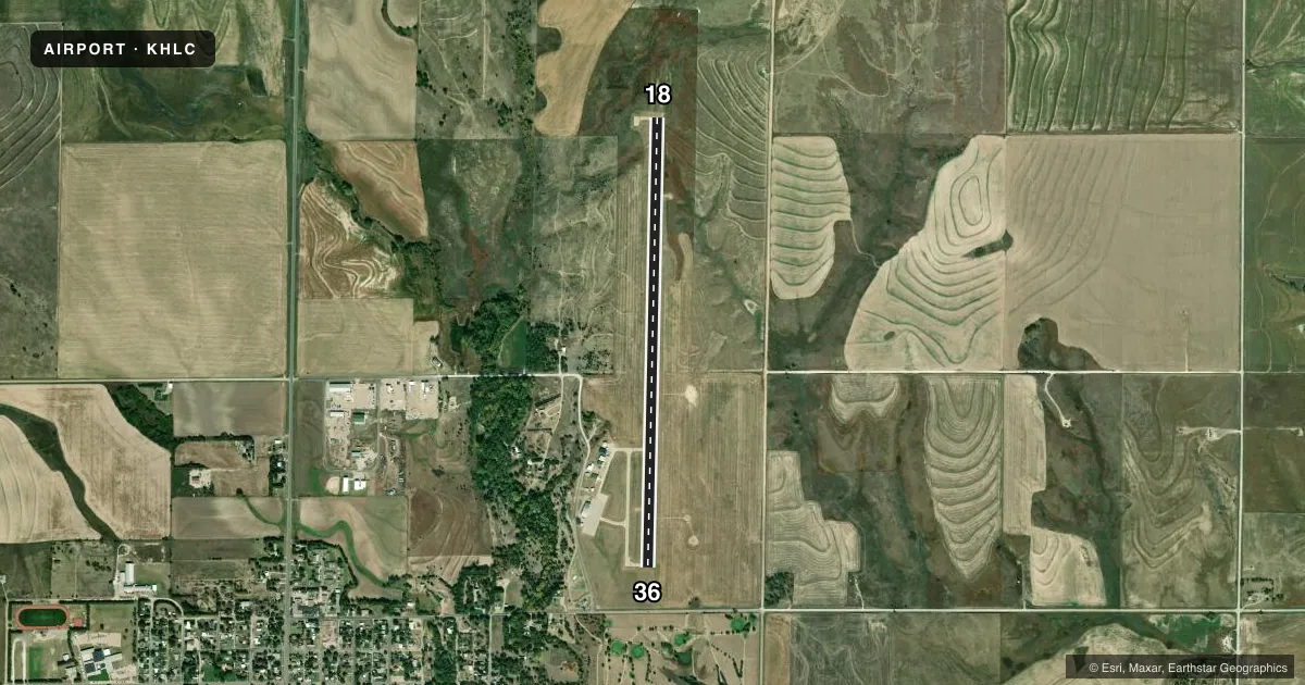
Airport sketch
Runways drawn to scale from FAA survey coordinates, rendered over satellite imagery. Not for navigation.
Approaches & charts
Services on the field
Fuel grades, oxygen, maintenance, ramp storage and lighting — as declared to the FAA by the airport operator.
Fuel & services
- Fuel
- 100LLA+
- Oxygen (bottled)
- Not available
- Oxygen (bulk)
- Not available
- Other services
- AGRI
Ramp & ground
- Transient storage
- Tie-down
- Hangar
- Landing fee
- No fee published
- Customs
- Not available
- Lighting schedule
- SEE RMK
- Beacon schedule
- SS-SR
- Beacon
- White / Green (civil land)(WG)
- Wind indicator
- Lighted
- Segmented circle
- Yes
Fuel & FBOs
Cheapest 100LL and Jet A on the field and nearby. Always confirm with the FBO before taxi.
Airport notes
Surface conditions, obstructions, local procedures, lighting outages and other notes published with each FAA cycle.
General notes
- AGRICULTURAL ACFT OPERG VCNTY ARPT DALGT HRS.
- FOR CD IF UNA TO CTC ON FSS FREQ, CTC DENVER ARTCC AT 303-651-4257.
Lighting notes
- ACTVT REIL RWY 18 & 36; PAPI RWY 18 & 36; HIRL RWY 18/36 - CTAF.
Fuel notes
- 100LLSELF SVC FUEL.
Approach & departure obstructions
- 184 FT BERM, 0-199 DSTC, 8- FT L.
Other notes
- PROVIDED APCH TO EACH RWY IS MAINTAINED FOR A MINIMUM 20:1 GLIDE SLOPE AND THE TRANSITIONAL SURFACE BE MAINTAINED FOR A 7:1 SLOPE.
- 124 HR ATTENDANT 785-421-5613.
- MANAGERASST POWER PLANT MGR/AMGR.
VFR map & nearby airports
VFR sectional. Tap any ICAO chip to open that airport.
Key facts · KHLC
Answer card- ICAO
- KHLC
- Name
- HILL CITY MUNI
- Location
- HILL CITY, KANSAS
- Elevation
- 2,238.4 ft MSL
- Traffic pattern altitude
- 3,038.4 ft MSL (800 AGL)
- Control tower
- Non-towered (use CTAF)
- Total runways
- 1
- Longest runway
- 18/36 · 5,001 ft
- Published ILS approaches
- 0
- Published frequencies
- 1
- Magnetic variation
- 5°
- Current flight rules
- VFR
- Current wind
- 030° at 22 kt
- Favored runway now
- RWY 36
Hill City Muni sits in Hill City, Kansas. Field elevation is 2,238.4 ft MSL. The airport has one runway. Runway 18/36 is 5,001 ft long with a concrete surface. There is no control tower. Use CTAF 122.9. Pattern altitude is 800 ft AGL, which is 3,038.4 ft MSL.
No ILS approaches are published here. The runway has high intensity lights, runway end identifier lights and PAPI on both ends. That helps at night or in marginal VMC. The published remarks also note a 4-foot berm near the departure end of runway 18, about 8 feet left of centerline. Plan for that on takeoff from 18.
The on-field FBO is Hill City Municipal Airport. It carries AVGAS 100LL and Jet A. Self-serve 100LL is available. A 24-hour attendant is listed at the airport phone number. Agricultural aircraft operate in the vicinity during daylight hours. Keep a sharp scan in the pattern and on climbout. For clearance delivery, if you cannot reach flight service, contact Denver ARTCC. This is a non-towered field with a single runway. Standard CTAF discipline matters.