METAR & TAF KRCP
KRCP does not publish a METAR.
Showing the nearest reporting station: KPHG (PHILLIPSBURG MUNI) · 23.4 NM away. Conditions at KRCP may differ.
METAR · KPHG
Observed 13:15Z
KPHG 271315Z AUTO VRB02KT 10SM CLR 26/20 A2981 RMK AO2
- Wind
- VAR @ 2 kt
- Visibility
- 10 SM
- Temp / Dew
- 26°C / 20°C
- Altimeter
- 29.81 inHg
- Clouds
- CLR
- Density alt
- 3,935 ft
- Ceiling
- Unlimited
- Rules
- VFR
Airport info & contacts
Manager on record, flight service, ARTCC, attendance schedule and pattern altitude — published by the FAA and refreshed every 28 days.
Location
- From city
- 5 NM S
- VFR sectional
- WICHITA
- ARTCC
- ZDV · DENVER
- NOTAM facility
- RCP (NOTAM-D)
Airport manager
- Name
- ROGER HRABE, ROOKS CO. ECONOMIC DVL
- Phone
- 785-425-6881
- Address
- 1721 P ROAD, STOCKTON KS 67669
Flight service · Hours
- FSS ICT
- WICHITA1-800-WX-BRIEF
- Attendance
- UNATTENDED
Frequencies
Tap any row to copy the frequency to your clipboard.
Runways & pattern
Full pagePattern entry · RWY 36
LEFT TRAFFICRunway end performance
| End | TORA | TODA | ASDA | LDA | VGSI | Approach lights | Obstruction |
|---|---|---|---|---|---|---|---|
| 18 | 5,000' | 5,000' | 5,000' | 5,000' | PAPI 4-box left(3°) | — | — |
| 36 | 5,000' | 5,000' | 5,000' | 5,000' | PAPI 4-box left(3°) | — | — |
Declared distances in feet. TORA = takeoff run available, TODA = takeoff distance, ASDA = accelerate-stop, LDA = landing distance.
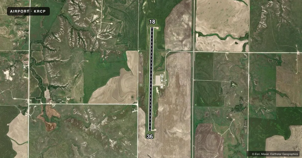
Airport sketch
Runways drawn to scale from FAA survey coordinates, rendered over satellite imagery. Not for navigation.
Approaches & charts
Services on the field
Fuel grades, oxygen, maintenance, ramp storage and lighting — as declared to the FAA by the airport operator.
Fuel & services
- Fuel
- 100LLA
Ramp & ground
- Transient storage
- Not published
- Lighting schedule
- SEE RMK
- Wind indicator
- Lighted
- Segmented circle
- Yes
Fuel & FBOs
Cheapest 100LL and Jet A on the field and nearby. Always confirm with the FBO before taxi.
Airport notes
Surface conditions, obstructions, local procedures, lighting outages and other notes published with each FAA cycle.
General notes
- FOR CD CTC DENVER ARTCC AT 303-651-4257.
Lighting notes
- ACTVT REIL RWY 18/36; PAPI RWY 18 & 36; MIRL RWY 18/36 - CTAF.
Fuel notes
- 100LLSELF-SVC FUEL AVBL WITH CREDIT CARD.
Other notes
- MANAGERROOKS CO DIR EC. DEV/AMGR.
- MANAGERALSO 785-203-0017
VFR map & nearby airports
VFR sectional. Tap any ICAO chip to open that airport.
Key facts · KRCP
Answer card- ICAO
- KRCP
- Name
- ROOKS COUNTY RGNL
- Location
- STOCKTON, KANSAS
- Elevation
- 1,999 ft MSL
- Traffic pattern altitude
- 2,999 ft MSL (1,000 AGL)
- Control tower
- Non-towered (use CTAF)
- Total runways
- 1
- Longest runway
- 18/36 · 5,000 ft
- Published ILS approaches
- 0
- Published frequencies
- 1
- Magnetic variation
- 5°
- Current flight rules
- VFR
- Current wind
- 000° at 2 kt
- Favored runway now
- RWY 36
Rooks County Rgnl sits in Stockton, Kansas. The field elevation is 1,999 ft MSL. It has one runway, 18/36, at 5,000 ft of concrete. There is no control tower. CTAF is 122.9.
No ILS approaches are published here. The runway lighting setup is useful to know before a night arrival. Runway end identifier lights are installed on 18 and 36. PAPI is installed on both runway ends. Medium intensity runway lights are on 18/36 and are controlled on CTAF.
The published pattern altitude is not given, so use the standard 1,000 ft AGL unless the current Chart Supplement says otherwise. That puts the light piston pattern at 2,999 ft MSL based on the listed field elevation. Self-service 100LL is available with a credit card. The on-field FBO is Rooks County Regional Airport. It carries AVGAS 100LL and JET A. Call (785) 425-6881 for current field details.
This is an uncontrolled airport in western Kansas. Expect to self-announce clearly and keep an eye out for local traffic. For clearance delivery, contact Denver Air Route Traffic Control Center at 303-651-4257. The airport manager is also listed in the remarks. If you need current operating details, verify with the airport operator or the current FAA Chart Supplement before you go.