METAR & TAF KRSL
Current METAR
Observed 15:53Z
KRSL 271553Z AUTO 21013KT 10SM CLR 37/16 A2981 RMK AO2 SLP066 T03670161 $
- Wind
- 210° @ 13 kt
- Visibility
- 10 SM
- Temp / Dew
- 37°C / 16°C
- Altimeter
- 29.81 inHg
- Clouds
- CLR
- Density alt
- 5,087 ft
- Ceiling
- Unlimited
- Rules
- VFR
Airport info & contacts
Manager on record, flight service, ARTCC, attendance schedule and pattern altitude — published by the FAA and refreshed every 28 days.
Location
- From city
- 2 NM SE
- VFR sectional
- WICHITA
- ARTCC
- ZKC · KANSAS CITY
- NOTAM facility
- RSL (NOTAM-D)
Airport manager
- Name
- CHADD STEVENSON
- Phone
- 785-483-6911
- Address
- CITY HALL, 133 W 8TH ST, RUSSELL KS 67665
Flight service · Hours
- FSS ICT
- WICHITA1-800-WX-BRIEF
- Attendance
- INTMNT
Frequencies
Tap any row to copy the frequency to your clipboard.
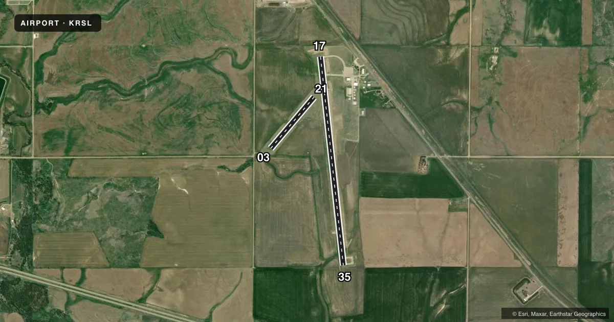
Runways & pattern
Full pagePattern entry · RWY 21
LEFT TRAFFIC| Runway | Heading (°M) | Length | Surface | Traffic |
|---|---|---|---|---|
| 17/35 | 167° / 347° | 5,000 ft | CONC | Standard L |
| 03/21Favored | 33° / 213° | 1,602 ft | TURF | Standard L |
Runway end performance
| End | TORA | TODA | ASDA | LDA | VGSI | Approach lights | Obstruction |
|---|---|---|---|---|---|---|---|
| 17 | — | — | — | — | PAPI 4-box left(3°) | — | 23', rr, 1080' from thr, 332' R of cntrln, slope 38 |
| 35 | — | — | — | — | PAPI 4-box left(3°) | — | — |
| 03 | — | — | — | — | — | — | 43', trees, 505' from thr, 89' R of cntrln, slope 12 |
| 21 | — | — | — | — | — | — | 42', ant, 1034' from thr, 146' R of cntrln, slope 24 |
Declared distances in feet. TORA = takeoff run available, TODA = takeoff distance, ASDA = accelerate-stop, LDA = landing distance.
Airport sketch
Runways drawn to scale from FAA survey coordinates, rendered over satellite imagery. Not for navigation.
Approaches & charts
Services on the field
Fuel grades, oxygen, maintenance, ramp storage and lighting — as declared to the FAA by the airport operator.
Fuel & services
- Fuel
- 100LL
- Airframe repair
- Major
- Power plant repair
- Major
- Other services
- AGRI,INSTR
Ramp & ground
- Transient storage
- Tie-down
- Landing fee
- No fee published
- Customs
- Not available
- Lighting schedule
- SEE RMK
- Beacon schedule
- SS-SR
- Beacon
- White / Green (civil land)(WG)
- Wind indicator
- Lighted
- Segmented circle
- Yes
Fuel & FBOs
Cheapest 100LL and Jet A on the field and nearby. Always confirm with the FBO before taxi.
Airport notes
Surface conditions, obstructions, local procedures, lighting outages and other notes published with each FAA cycle.
General notes
- PUB PHONE ACCESS AT ARPT.
- FOR CD IF UNA TO CTC ON FSS FREQ, CTC KANSAS CITY ARTCC AT 913-254-8508.
- NO LINE OF SIGHT BETWEEN RWY ENDS.
Lighting notes
- ACTVT REIL RWY 17 & 35; PAPI RWY 17 & 35; MIRL RWY 17/35 -- CTAF.
Fuel notes
- 100LLFUEL 24 HR SELF-SERVE.
Approach & departure obstructions
- 0303/21 MKD WITH HALF BARRELS ON POSTS PAINTED BLACK & YELLOW.
Other notes
- CONDL: PROVIDED A CLEAR APPROACH TO EACH RWY IS MAINTAINED FOR A MINIMUM 20:1 GLIDE SLOPE AND THE TRANSITIONAL SURFACE BE MAINTAINED FOR A 7:1 SLOPE.
VFR map & nearby airports
VFR sectional. Tap any ICAO chip to open that airport.
Key facts · KRSL
Answer card- ICAO
- KRSL
- Name
- RUSSELL MUNI
- Location
- RUSSELL, KANSAS
- Elevation
- 1,863.5 ft MSL
- Traffic pattern altitude
- 2,863.5 ft MSL (1,000 AGL)
- Control tower
- Non-towered (use CTAF)
- Total runways
- 2
- Longest runway
- 17/35 · 5,000 ft
- Published ILS approaches
- 0
- Published frequencies
- 2
- Magnetic variation
- 7°
- Current flight rules
- VFR
- Current wind
- 210° at 13 kt
- Favored runway now
- RWY 21
Russell Muni is in Russell, Kansas. Field elevation is 1,863.5 ft MSL. The airport has two runways. The longest is runway 17/35 at 5,000 ft of concrete. Runway 03/21 is 1,602 ft of turf. There is no control tower. CTAF and UNICOM are both 122.7. No ILS approaches are published here.
Pattern altitude is not published. Use the standard 1,000 ft AGL for light piston traffic unless local procedures or the current Chart Supplement say otherwise. The on-field FBO is Russell Municipal Airport. It carries 100LL. Fuel is available 24 hours through self-service. The published remarks also note runway end identifier lights, PAPI and medium intensity runway lighting on 17/35. That makes the paved runway the one most pilots will want to plan for after dark or in lower visibility.
A few operational points matter here. There is no line of sight between runway ends. Runways 03 and 21 are marked with half barrels on posts painted black and yellow. For clearance delivery, if you cannot reach flight service, Kansas City Center is listed as the backup contact. Expect a non-towered field with self-announce traffic on 122.7. Check the current Chart Supplement for any noise or other local restrictions before flying in.