METAR & TAF 1K6
1K6 does not publish a METAR.
Showing the nearest reporting station: KGBD (GREAT BEND MUNI) · 12.4 NM away. Conditions at 1K6 may differ.
METAR · KGBD
Observed 12:56Z
KGBD 271256Z AUTO 20012KT CLR 27/16 A2986 RMK AO2 SLP085 T02720161 PWINO $
- Wind
- 200° @ 12 kt
- Visibility
- —
- Temp / Dew
- 27°C / 16°C
- Altimeter
- 29.86 inHg
- Clouds
- CLR
- Density alt
- 3,743 ft
- Ceiling
- Unlimited
- Rules
- VFR
Airport info & contacts
Manager on record, flight service, ARTCC, attendance schedule and pattern altitude — published by the FAA and refreshed every 28 days.
Location
- From city
- 2 NM NW
- VFR sectional
- WICHITA
- ARTCC
- ZKC · KANSAS CITY
- NOTAM facility
- ICT (NOTAM-D)
Airport manager
- Name
- CHRIS KOMAREK
- Phone
- 620-564-3161
- Address
- PO BOX 278, ELLINWOOD KS 67526
Flight service · Hours
- FSS ICT
- WICHITA1-800-WX-BRIEF
- Attendance
- Unattended
Frequencies
Tap any row to copy the frequency to your clipboard.
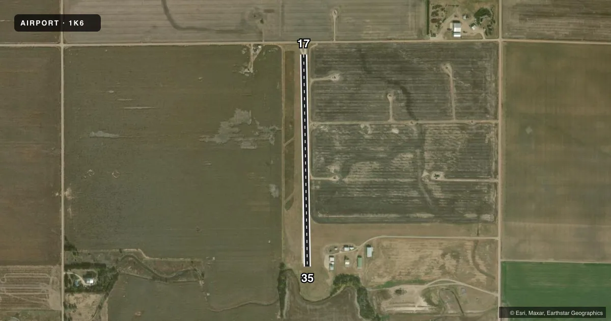
Runways & pattern
Full pagePattern entry · RWY 17
LEFT TRAFFICRunway end performance
| End | TORA | TODA | ASDA | LDA | VGSI | Approach lights | Obstruction |
|---|---|---|---|---|---|---|---|
| 17 | — | — | — | — | — | — | 15', road, 95' from thr, 0' R of cntrln, slope 6 |
Declared distances in feet. TORA = takeoff run available, TODA = takeoff distance, ASDA = accelerate-stop, LDA = landing distance.
Airport sketch
Runways drawn to scale from FAA survey coordinates, rendered over satellite imagery. Not for navigation.
Approaches & charts
Services on the field
Fuel grades, oxygen, maintenance, ramp storage and lighting — as declared to the FAA by the airport operator.
Fuel & services
- Fuel
- Not available
- Other services
- AGRI
Ramp & ground
- Transient storage
- Tie-down
- Landing fee
- No fee published
- Lighting schedule
- SS-SR
- Wind indicator
- Lighted
- Segmented circle
- No
Fuel & FBOs
Cheapest 100LL and Jet A on the field and nearby. Always confirm with the FBO before taxi.
Airport notes
Surface conditions, obstructions, local procedures, lighting outages and other notes published with each FAA cycle.
General notes
- 2 FT DITCH AT RWY 26 THRESHOLD NOT MKD
- LARGE DRAINAGE DITCH 400 FT SOUTH OF RWY 35
- FOR CD CTC KANSAS CITY ARTCC AT 913-254-8508.
Approach & departure obstructions
- 26ROAD AT 70 FT LEFT CNTRLN OF RY 26. POWER LINE UNDERGROUND IN APCH PATH.
Other notes
- ARPT CONSTRUCTED PRIOR TO 1959.
- MANAGERAFTER HOURS CONTACT CITY OF ELLINWOOD 620-564-2211
- 08/26VERY SOFT AFTER RAIN.
- 17/35PATCHES OF GRASSY VEGETATION/GRAVEL MIXTURE AER 17 ALONG CNTRLN.
VFR map & nearby airports
VFR sectional. Tap any ICAO chip to open that airport.
Key facts · 1K6
Answer card- ICAO
- 1K6
- Name
- ELLINWOOD MUNI
- Location
- ELLINWOOD, KANSAS
- Elevation
- 1,797 ft MSL
- Traffic pattern altitude
- 2,797 ft MSL (1,000 AGL)
- Control tower
- Non-towered (use CTAF)
- Total runways
- 1
- Longest runway
- 17/35 · 2,550 ft
- Published ILS approaches
- 0
- Published frequencies
- 1
- Magnetic variation
- 8°
- Current flight rules
- VFR
- Current wind
- 200° at 12 kt
- Favored runway now
- RWY 17
Ellinwood Muni sits in Ellinwood, Kansas. Field elevation is 1,797 ft MSL. The airport has one runway. Runway 17/35 is 2,550 ft long with a turf-gravel surface. It is the longest runway on the field. There is no control tower. CTAF is 122.9.
No ILS approaches are published here. Pattern altitude is not published, so use the standard 1,000 ft AGL for light piston operations unless the current FAA Chart Supplement says otherwise. The field sits in a low-density part of central Kansas. Expect a simple non-towered arrival. Keep an eye out for the published surface notes. Runway 17 has patches of grassy vegetation and gravel near the centerline. There is also a large drainage ditch 400 feet south of runway 35. The airport was built before 1959, so plan for a smaller rural strip with limited services.
No on-field FBOs are listed. Check with the airport operator or the current FAA Chart Supplement before you go if you need fuel or local support. For clearance delivery, Kansas City ARTCC is the published contact. After hours, contact the City of Ellinwood. The published remarks also note an underground power line in the approach path near runway 26, so verify current field conditions before using any route that brings you near that area.