METAR & TAF KLQR
Current METAR
Observed 17:15Z
KLQR 271715Z AUTO 21013KT 10SM CLR 39/18 A2984 RMK AO2
- Wind
- 210° @ 13 kt
- Visibility
- 10 SM
- Temp / Dew
- 39°C / 18°C
- Altimeter
- 29.84 inHg
- Clouds
- CLR
- Density alt
- 5,474 ft
- Ceiling
- Unlimited
- Rules
- VFR
Airport info & contacts
Manager on record, flight service, ARTCC, attendance schedule and pattern altitude — published by the FAA and refreshed every 28 days.
Location
- From city
- 2 NM N
- VFR sectional
- WICHITA
- ARTCC
- ZKC · KANSAS CITY
- NOTAM facility
- ICT (NOTAM-D)
Airport manager
- Name
- STEVE GROSS
- Phone
- 620-285-8580
- Address
- RR#1 BOX 145B, LARNED KS 67550
Flight service · Hours
- FSS ICT
- WICHITA1-800-WX-BRIEF
- Attendance
- MON-FRI · 0800-1700
- SAT · 0800-1200
Frequencies
Tap any row to copy the frequency to your clipboard.
Runways & pattern
Full pagePattern entry · RWY 22
LEFT TRAFFIC| Runway | Heading (°M) | Length | Surface | Traffic |
|---|---|---|---|---|
| 17/35 | 172° / 352° | 4,201 ft | CONC | Standard L |
| 04/22Favored | 37° / 217° | 2,860 ft | TURF | Standard L |
| 12/30 | 127° / 307° | 2,830 ft | TURF | Standard L |
Runway end performance
| End | TORA | TODA | ASDA | LDA | VGSI | Approach lights | Obstruction |
|---|---|---|---|---|---|---|---|
| 17 | — | — | — | — | PAPI 2-box left(3°) | — | 55', trees, 1010' from thr, 240' R of cntrln, slope 14 |
| 35 | — | — | — | — | PAPI 2-box left(3°) | — | 15', road, 515' from thr, 0' R of cntrln, slope 21 |
Declared distances in feet. TORA = takeoff run available, TODA = takeoff distance, ASDA = accelerate-stop, LDA = landing distance.
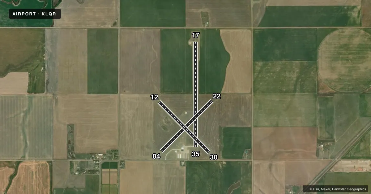
Airport sketch
Runways drawn to scale from FAA survey coordinates, rendered over satellite imagery. Not for navigation.
Approaches & charts
Services on the field
Fuel grades, oxygen, maintenance, ramp storage and lighting — as declared to the FAA by the airport operator.
Fuel & services
- Fuel
- 100LL
- Oxygen (bottled)
- Not available
- Oxygen (bulk)
- Not available
- Airframe repair
- Not available
- Power plant repair
- Not available
- Other services
- AGRI,INSTR,RNTL
Ramp & ground
- Transient storage
- Tie-down
- Hangar
- Landing fee
- No fee published
- Customs
- Not available
- Lighting schedule
- SEE RMK
- Beacon schedule
- SS-SR
- Beacon
- White / Green (civil land)(WG)
- Wind indicator
- Lighted
- Segmented circle
- Yes
Fuel & FBOs
Cheapest 100LL and Jet A on the field and nearby. Always confirm with the FBO before taxi.
Airport notes
Surface conditions, obstructions, local procedures, lighting outages and other notes published with each FAA cycle.
General notes
- INTXN RYS 04/22 & 12/30 SOFT WHEN WET.
- FOR CD CTC KANSAS CITY ARTCC AT 913-254-8508.
Lighting notes
- ACTVT MIRL RWY 17/35; PAPI & REIL RWYS 17 & 35 - CTAF.
Fuel notes
- 100LLFUEL AVBL 24 HRS WITH CREDIT CARD.
Other notes
- MANAGERMGR PHONE 620-285-8580 OR 620-285-5609
VFR map & nearby airports
VFR sectional. Tap any ICAO chip to open that airport.
Key facts · KLQR
Answer card- ICAO
- KLQR
- Name
- LARNED-PAWNEE COUNTY
- Location
- LARNED, KANSAS
- Elevation
- 2,012.1 ft MSL
- Traffic pattern altitude
- 3,012.1 ft MSL (1,000 AGL)
- Control tower
- Non-towered (use CTAF)
- Total runways
- 3
- Longest runway
- 17/35 · 4,201 ft
- Published ILS approaches
- 0
- Published frequencies
- 2
- Magnetic variation
- 8°
- Current flight rules
- VFR
- Current wind
- 210° at 13 kt
- Favored runway now
- RWY 22
Larned-Pawnee County Airport sits in Larned, Kansas. The field elevation is 2,012.1 ft MSL. It has three runways. The longest is runway 17/35 at 4,201 ft on concrete. Runways 04/22 and 12/30 are turf. The airport is non-towered. Pilots should plan for self-announce traffic on CTAF 122.8. No ILS approaches are published here.
The pattern altitude is not published. Use the standard 1,000 ft AGL for light piston operations unless the current Chart Supplement says otherwise. The on-field FBO is Larned Municipal Airport. It carries AVGAS 100LL. Fuel is available 24 hours with a credit card. The published remarks also note that the intersection of runways 04/22 and 12/30 can be soft when wet. That matters if you are planning a turf arrival after rain.
Runway 17/35 has medium intensity runway lights. PAPI and REIL are available on runways 17 and 35. Use the common traffic advisory frequency for traffic calls. If you need clearance delivery, Kansas City ARTCC is listed in the remarks. For a first visit, the big items are the turf condition after rain, the lack of published ILS and the elevation. Density altitude can matter here on warm days.