METAR & TAF 33K
33K does not publish a METAR.
Showing the nearest reporting station: KLQR (LARNED-PAWNEE COUNTY) · 23.4 NM away. Conditions at 33K may differ.
METAR · KLQR
Observed 17:15Z
KLQR 271715Z AUTO 21013KT 10SM CLR 39/18 A2984 RMK AO2
- Wind
- 210° @ 13 kt
- Visibility
- 10 SM
- Temp / Dew
- 39°C / 18°C
- Altimeter
- 29.84 inHg
- Clouds
- CLR
- Density alt
- 5,671 ft
- Ceiling
- Unlimited
- Rules
- VFR
Airport info & contacts
Manager on record, flight service, ARTCC, attendance schedule and pattern altitude — published by the FAA and refreshed every 28 days.
Location
- From city
- 0 NM SE
- VFR sectional
- WICHITA
- ARTCC
- ZKC · KANSAS CITY
- NOTAM facility
- ICT (NOTAM-D)
Airport manager
- Name
- JAY DILL
- Phone
- 620-659-3611
- Address
- PO BOX 7, KINSLEY KS 67547
Flight service · Hours
- FSS ICT
- WICHITA1-800-WX-BRIEF
- Attendance
- Unattended
Frequencies
Tap any row to copy the frequency to your clipboard.
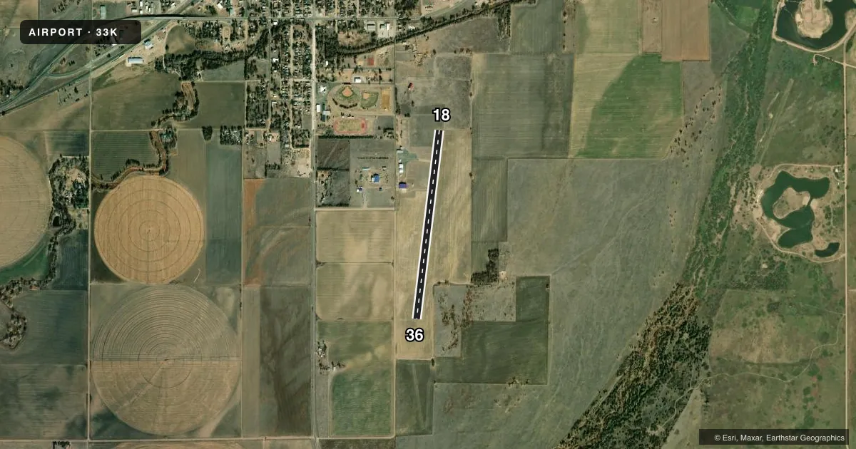
Runways & pattern
Full pagePattern entry · RWY 18
LEFT TRAFFICAirport sketch
Runways drawn to scale from FAA survey coordinates, rendered over satellite imagery. Not for navigation.
Approaches & charts
Services on the field
Fuel grades, oxygen, maintenance, ramp storage and lighting — as declared to the FAA by the airport operator.
Fuel & services
- Fuel
- 100LL
- Oxygen (bottled)
- Not available
- Oxygen (bulk)
- Not available
- Airframe repair
- Not available
- Power plant repair
- Not available
- Other services
- AGRI
Ramp & ground
- Transient storage
- Tie-down
- Landing fee
- No fee published
- Customs
- Not available
- Lighting schedule
- SS-SR
- Beacon schedule
- SS-SR
- Beacon
- White / Green (civil land)(WG)
- Wind indicator
- Lighted
- Segmented circle
- No
Fuel & FBOs
Cheapest 100LL and Jet A on the field and nearby. Always confirm with the FBO before taxi.
Airport notes
Surface conditions, obstructions, local procedures, lighting outages and other notes published with each FAA cycle.
General notes
- 165' TWR 5000' N AND 1800' W OF AER 18.
- FOR CD CTC KANSAS CITY ARTCC AT 913-254-8508.
Fuel notes
- 100LLFUEL IS SELF SERVE 24/7
Runway surface & condition
- 18/36NSTD LIRL; FIRST 180 FT RY 18 UNLGTD; FIRST 385 FT RY 36 UNLGTD .
Approach & departure obstructions
- 18+4FT FENCE 2 FT FROM AER 18, 70 FT L OF CL.
- 18CONTROLLING OBSTN EXCEEDS A 45 DEG SLP.
Other notes
- THIS AIRPORT HAS BEEN SURVEYED BY THE NATIONAL GEODETIC SURVEY.
- MANAGERAFTER HOURS OR EMERGENCY CALL 620-388-0266
VFR map & nearby airports
VFR sectional. Tap any ICAO chip to open that airport.
Key facts · 33K
Answer card- ICAO
- 33K
- Name
- KINSLEY MUNI
- Location
- KINSLEY, KANSAS
- Elevation
- 2,171.1 ft MSL
- Traffic pattern altitude
- 3,171.1 ft MSL (1,000 AGL)
- Control tower
- Non-towered (use CTAF)
- Total runways
- 1
- Longest runway
- 18/36 · 3,290 ft
- Published ILS approaches
- 0
- Published frequencies
- 1
- Magnetic variation
- 8°
- Current flight rules
- VFR
- Current wind
- 210° at 13 kt
- Favored runway now
- RWY 18
Kinsley Muni sits in Kinsley, Kansas. Field elevation is 2,171.1 ft MSL. The airport has one runway. Runway 18/36 is 3,290 ft long with asphalt pavement. There is no control tower. CTAF is 122.9. No ILS approaches are published here. Pattern altitude is not published, so use the standard 1,000 ft AGL for light piston traffic unless the current Chart Supplement says otherwise.
Tyree Ag is on the field. It carries 100LL. Fuel is self-serve 24 hours a day, 7 days a week. Published remarks also note a 165-foot tower about 5,000 feet north and 1,800 feet west of the airport. There is also a 4-foot fence close to the departure end of runway 18, offset left of centerline. Runway 18 has a controlling obstruction that exceeds a 45 degree slope. The first 180 feet of runway 18 are unlighted. The first 385 feet of runway 36 are unlighted. That matters for night work and for short-field planning.
This is a non-towered field in western Kansas with a single runway and no published ILS. Check the current FAA Chart Supplement for any changes before you go. For clearance delivery, the published contact is Kansas City ARTCC. After hours or for emergencies, the airport manager number is listed in the remarks.