METAR & TAF 8K0
8K0 does not publish a METAR.
Showing the nearest reporting station: KDDC (DODGE CITY RGNL) · 20.2 NM away. Conditions at 8K0 may differ.
METAR · KDDC
Observed 12:52Z
KDDC 271252Z AUTO 21011KT 8SM CLR 27/15 A2989 RMK AO2 SLP081 T02670150
- Wind
- 210° @ 11 kt
- Visibility
- 8 SM
- Temp / Dew
- 27°C / 15°C
- Altimeter
- 29.89 inHg
- Clouds
- CLR
- Density alt
- 4,476 ft
- Ceiling
- Unlimited
- Rules
- VFR
Airport info & contacts
Manager on record, flight service, ARTCC, attendance schedule and pattern altitude — published by the FAA and refreshed every 28 days.
Location
- From city
- 1 NM SW
- VFR sectional
- WICHITA
- ARTCC
- ZKC · KANSAS CITY
- NOTAM facility
- ICT (NOTAM-D)
Airport manager
- Name
- LARRY RANDALL
- Phone
- 620-826-5519
- Address
- BOX 641, BUCKLIN KS 67834
Flight service · Hours
- FSS ICT
- WICHITA1-800-WX-BRIEF
- Attendance
- Unattended
Frequencies
Tap any row to copy the frequency to your clipboard.
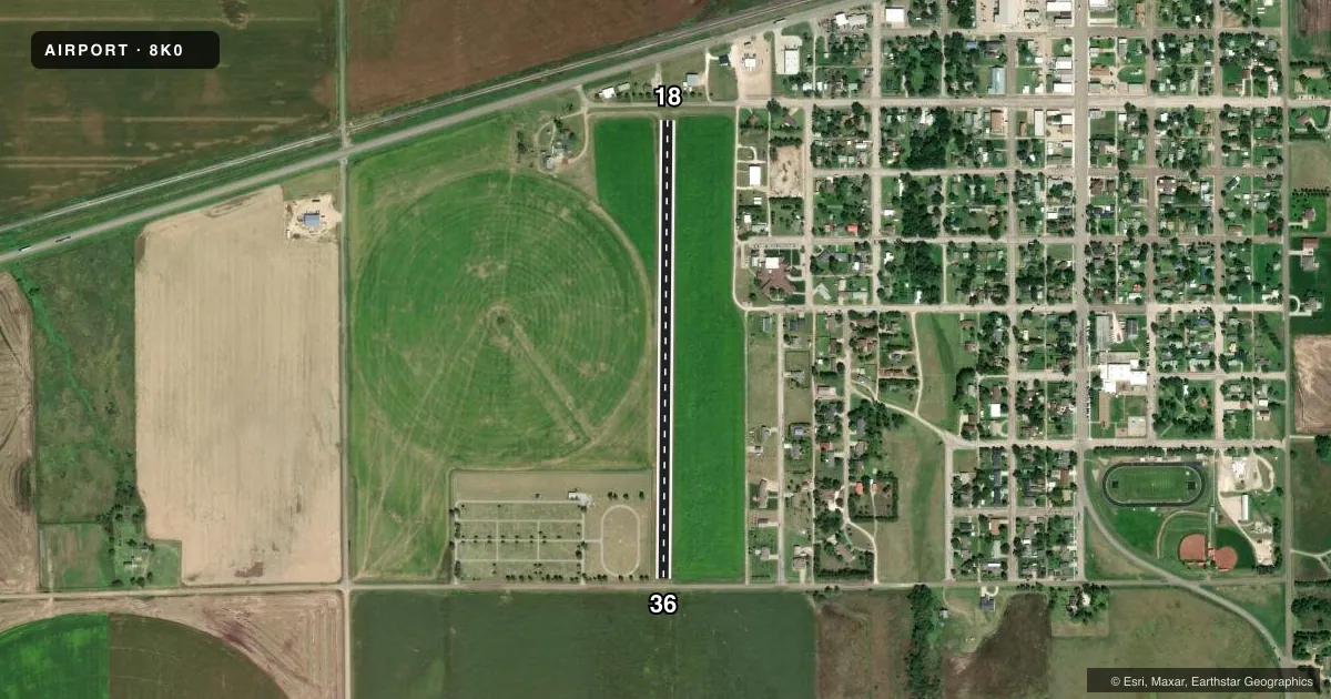
Runways & pattern
Full pagePattern entry · RWY 18
LEFT TRAFFICRunway end performance
| End | TORA | TODA | ASDA | LDA | VGSI | Approach lights | Obstruction |
|---|---|---|---|---|---|---|---|
| 18 | — | — | — | — | — | — | 25', pole, 100' from thr, 120' R of cntrln, slope 4 |
| 36 | — | — | — | — | — | — | 15', road, 0' from thr, 0' R of cntrln, slope 0 |
Declared distances in feet. TORA = takeoff run available, TODA = takeoff distance, ASDA = accelerate-stop, LDA = landing distance.
Airport sketch
Runways drawn to scale from FAA survey coordinates, rendered over satellite imagery. Not for navigation.
Approaches & charts
Services on the field
Fuel grades, oxygen, maintenance, ramp storage and lighting — as declared to the FAA by the airport operator.
Fuel & services
- Fuel
- Not available
- Oxygen (bottled)
- Not available
- Oxygen (bulk)
- Not available
- Airframe repair
- Not available
- Power plant repair
- Not available
- Other services
- AGRI
Ramp & ground
- Transient storage
- Not published
- Landing fee
- No fee published
- Wind indicator
- Yes
- Segmented circle
- No
Fuel & FBOs
Cheapest 100LL and Jet A on the field and nearby. Always confirm with the FBO before taxi.
Airport notes
Surface conditions, obstructions, local procedures, lighting outages and other notes published with each FAA cycle.
General notes
- RWY 18 HAS +20' BLDG 120' FROM RWY END 50' R OF CNTRLN; +15' ROAD 60' FROM RWY END L & R.
- FOR CD CTC KANSAS CITY ARTCC AT 913-254-8508.
VFR map & nearby airports
VFR sectional. Tap any ICAO chip to open that airport.
Key facts · 8K0
Answer card- ICAO
- 8K0
- Name
- BUCKLIN
- Location
- BUCKLIN, KANSAS
- Elevation
- 2,418 ft MSL
- Traffic pattern altitude
- 3,418 ft MSL (1,000 AGL)
- Control tower
- Non-towered (use CTAF)
- Total runways
- 1
- Longest runway
- 18/36 · 2,560 ft
- Published ILS approaches
- 0
- Published frequencies
- 1
- Magnetic variation
- 8°
- Current flight rules
- VFR
- Current wind
- 210° at 11 kt
- Favored runway now
- RWY 18
Bucklin Airport sits in Bucklin, Kansas. The field elevation is 2,418 ft MSL. It has one runway. Runway 18/36 is 2,560 ft long and is turf. There is no control tower. CTAF is 122.9.
No ILS approaches are published here. The pattern altitude is not published, so use the standard 1,000 ft AGL for light piston operations unless the current Chart Supplement says otherwise. That puts the pattern at 3,418 ft MSL based on the listed field elevation. Runway headings are magnetic. The runway is aligned 181° and 1°.
Published remarks call out obstacles near the runway 18 end. There is a 20-foot building 120 feet from the end, 50 feet right of centerline. There is also a 15-foot road 60 feet from the end on both sides of centerline. That makes a careful short-field and obstacle check important before arrival or departure. No on-field FBOs are listed, so verify fuel and services with the airport operator or the field directly before you go. If you need clearance delivery, Kansas City Air Route Traffic Control Center is listed in the remarks. For a first visit, plan for a non-towered turf field at higher elevation with no published precision approach support.