METAR & TAF 18K
18K does not publish a METAR.
Showing the nearest reporting station: KDDC (DODGE CITY RGNL) · 25.1 NM away. Conditions at 18K may differ.
METAR · KDDC
Observed 11:52Z
KDDC 271152Z AUTO 22012KT 8SM CLR 25/15 A2989 RMK AO2 SLP080 T02500150 10289 20250 53000
- Wind
- 220° @ 12 kt
- Visibility
- 8 SM
- Temp / Dew
- 25°C / 15°C
- Altimeter
- 29.89 inHg
- Clouds
- CLR
- Density alt
- 4,316 ft
- Ceiling
- Unlimited
- Rules
- VFR
Airport info & contacts
Manager on record, flight service, ARTCC, attendance schedule and pattern altitude — published by the FAA and refreshed every 28 days.
Location
- From city
- 0 NM E
- VFR sectional
- WICHITA
- ARTCC
- ZKC · KANSAS CITY
- NOTAM facility
- ICT (NOTAM-D)
Airport manager
- Name
- LARRY DEWELL
- Phone
- 620-338-1576
- Address
- 7009 27 TH RD, P. O. BOX 319, FOWLER KS 67844
Flight service · Hours
- FSS ICT
- WICHITA1-800-WX-BRIEF
- Attendance
- Unattended
Frequencies
Tap any row to copy the frequency to your clipboard.
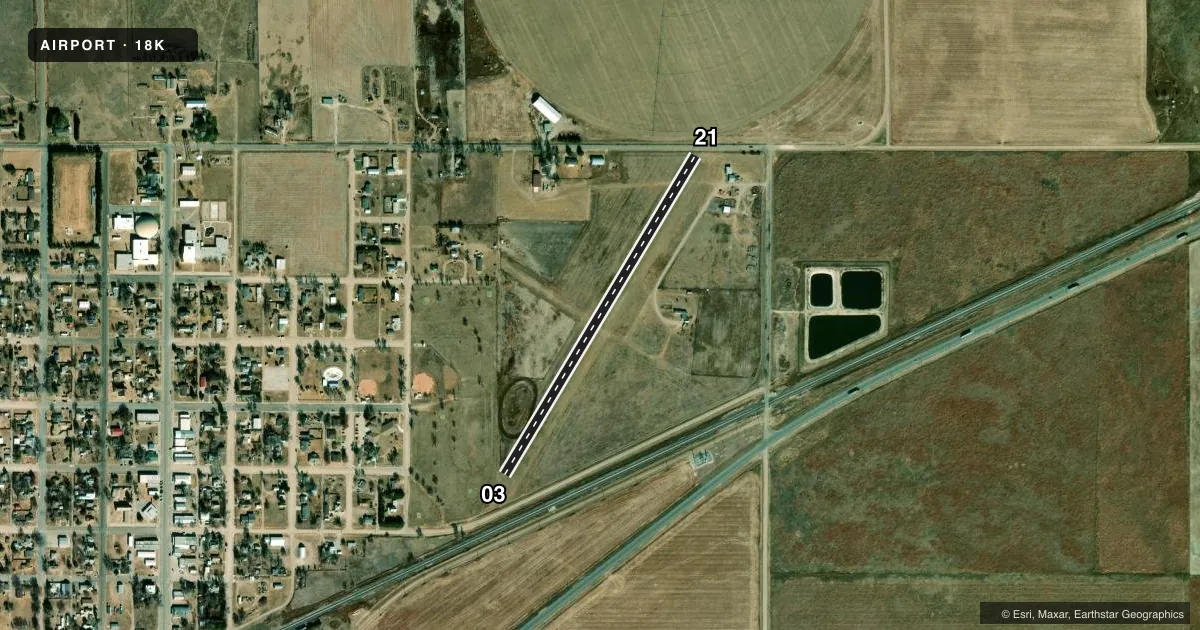
Runways & pattern
Full pagePattern entry · RWY 21
LEFT TRAFFICRunway end performance
| End | TORA | TODA | ASDA | LDA | VGSI | Approach lights | Obstruction |
|---|---|---|---|---|---|---|---|
| 03 | — | — | — | — | — | — | 15', road, 45' from thr, 0' R of cntrln, slope 3 |
| 21 | — | — | — | — | — | — | 15', road, 150' from thr, 0' R of cntrln, slope 10 |
Declared distances in feet. TORA = takeoff run available, TODA = takeoff distance, ASDA = accelerate-stop, LDA = landing distance.
Airport sketch
Runways drawn to scale from FAA survey coordinates, rendered over satellite imagery. Not for navigation.
Approaches & charts
Services on the field
Fuel grades, oxygen, maintenance, ramp storage and lighting — as declared to the FAA by the airport operator.
Fuel & services
- Fuel
- Not available
Ramp & ground
- Transient storage
- Tie-down
- Landing fee
- No fee published
- Wind indicator
- Yes
- Segmented circle
- No
Fuel & FBOs
Cheapest 100LL and Jet A on the field and nearby. Always confirm with the FBO before taxi.
Airport notes
Surface conditions, obstructions, local procedures, lighting outages and other notes published with each FAA cycle.
General notes
- FOR CD CTC KANSAS CITY ARTCC AT 913-254-8508.
Approach & departure obstructions
- 03/21 MKD WITH SMALL RED REFLECTORS: SOLAR LIGHTS & RED CONES.
- 0328' POLES LGTD PLINE APRX 450' S OF SW END OF RWY.
Other notes
- PROVIDED APCH SLOPES ARE CLEARED, THR DSPLCD SUFFICIENT DIST THAT THE ROADS, RR, & PWR LINES WOULD NO LONGER PRESENT A PSBL UNSAFE COND FOR ACFT.
VFR map & nearby airports
VFR sectional. Tap any ICAO chip to open that airport.
Key facts · 18K
Answer card- ICAO
- 18K
- Name
- FOWLER
- Location
- FOWLER, KANSAS
- Elevation
- 2,483 ft MSL
- Traffic pattern altitude
- 3,483 ft MSL (1,000 AGL)
- Control tower
- Non-towered (use CTAF)
- Total runways
- 1
- Longest runway
- 03/21 · 2,310 ft
- Published ILS approaches
- 0
- Published frequencies
- 1
- Magnetic variation
- 8°
- Current flight rules
- VFR
- Current wind
- 220° at 12 kt
- Favored runway now
- RWY 21
Fowler Airport (18K) sits in Fowler, Kansas. The field elevation is 2,483 ft MSL. It has one runway, 03/21, which is 2,310 ft of turf. There is no control tower. CTAF is 122.9.
No ILS approaches are published here. Pattern altitude is not published, so use the standard 1,000 ft AGL for light piston operations unless the current FAA Chart Supplement says otherwise. The runway markings are simple. Runways 03 and 21 use small red reflectors, solar lights and red cones. There are 28-foot lighted poles on a power line about 450 feet south of the southwest end of runway 03. Keep that in mind on the south side of the field.
There are no on-field FBOs listed. Contact the airport operator directly or call the field on CTAF for current services before you go. For clearance delivery, Kansas City ARTCC is listed in the remarks. With one short turf runway and no tower, this is a field where a clean stabilized approach matters. Check the current FAA Chart Supplement for any published noise or curfew restrictions before flying in.