METAR & TAF 19S
Current METAR
Observed 13:55Z
K19S 221355Z AUTO 17015KT 10SM OVC010 16/14 A2993 RMK AO2 T01580144
- Wind
- 170° @ 15 kt
- Visibility
- 10 SM
- Temp / Dew
- 16°C / 14°C
- Altimeter
- 29.93 inHg
- Clouds
- OVC
- Density alt
- 3,717 ft
- Ceiling
- 1,000 ft AGL
- Rules
- MVFR
Airport info & contacts
Manager on record, flight service, ARTCC, attendance schedule and pattern altitude — published by the FAA and refreshed every 28 days.
Location
- From city
- 1 NM NE
- VFR sectional
- WICHITA
- ARTCC
- ZKC · KANSAS CITY
- NOTAM facility
- ICT (NOTAM-D)
Airport manager
- Name
- DAYLEN ELSEY
- Phone
- 620-675-2326
- Address
- BOX 934, SUBLETTE KS 67877
Flight service · Hours
- FSS ICT
- WICHITA1-800-WX-BRIEF
- Attendance
- Unattended
Frequencies
Tap any row to copy the frequency to your clipboard.
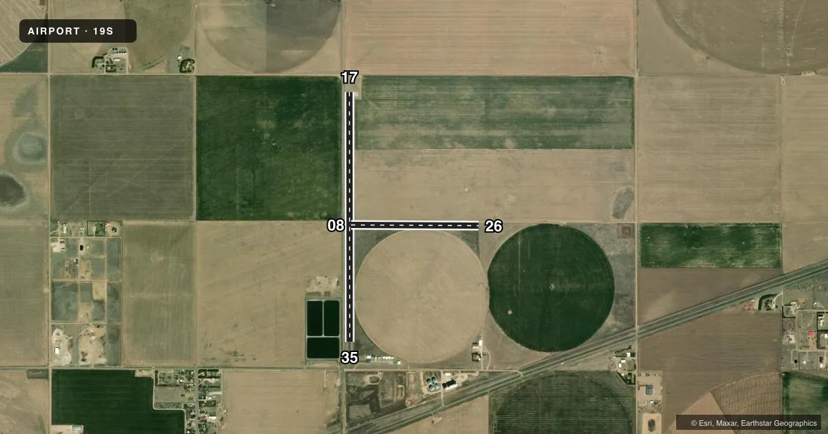
Runways & pattern
Full pagePattern entry · RWY 17
LEFT TRAFFIC| Runway | Heading (°M) | Length | Surface | Traffic |
|---|---|---|---|---|
| 17/35Favored | 171° / 351° | 4,498 ft | ASPH | Standard L |
| 08/26 | 81° / 261° | 2,300 ft | TURF | Standard L |
Runway end performance
| End | TORA | TODA | ASDA | LDA | VGSI | Approach lights | Obstruction |
|---|---|---|---|---|---|---|---|
| 17 | — | — | — | — | — | — | 17', road, 201' from thr, 96' R of cntrln, slope 0 |
| 35 | — | — | — | — | — | — | 17', road, 201' from thr, 96' R of cntrln, slope 0 |
| 08 | — | — | — | — | — | — | 17', road, 125' from thr, 145' R of cntrln, slope 7 |
| 26 | — | — | — | — | — | — | 10', tower, 130' from thr, slope 0 |
Declared distances in feet. TORA = takeoff run available, TODA = takeoff distance, ASDA = accelerate-stop, LDA = landing distance.
Airport sketch
Runways drawn to scale from FAA survey coordinates, rendered over satellite imagery. Not for navigation.
Approaches & charts
Services on the field
Fuel grades, oxygen, maintenance, ramp storage and lighting — as declared to the FAA by the airport operator.
Fuel & services
- Fuel
- Not available
- Oxygen (bottled)
- Not available
- Oxygen (bulk)
- Not available
- Airframe repair
- Not available
- Power plant repair
- Not available
Ramp & ground
- Transient storage
- Tie-down
- Landing fee
- No fee published
- Lighting schedule
- SS-SR
- Wind indicator
- Yes
- Segmented circle
- No
Fuel & FBOs
Cheapest 100LL and Jet A on the field and nearby. Always confirm with the FBO before taxi.
Airport notes
Surface conditions, obstructions, local procedures, lighting outages and other notes published with each FAA cycle.
General notes
- 150 FT LGTD GRAIN ELEVATOR S OF RWY 08/26, 2750 FT.
- FOR CD CTC KANSAS CITY ARTCC AT 913-254-8508.
Approach & departure obstructions
- 1717 FT RD, 0-199 FT DSTC, 96 FT R.
- 3517 FT RD, 0-199 FT DSTC, 96 FT L.
- 17MKG FADED.
- 35MKG FADED.
- 1717 FT PARALLEL TO RWY.
Other notes
- 08/26SFC ROUGH. ANIMAL HOLES.
VFR map & nearby airports
VFR sectional. Tap any ICAO chip to open that airport.
Key facts · 19S
Answer card- ICAO
- 19S
- Name
- SUBLETTE MUNI
- Location
- SUBLETTE, KANSAS
- Elevation
- 2,910.7 ft MSL
- Traffic pattern altitude
- 3,910.7 ft MSL (1,000 AGL)
- Control tower
- Non-towered (use CTAF)
- Total runways
- 2
- Longest runway
- 17/35 · 4,498 ft
- Published ILS approaches
- 0
- Published frequencies
- 2
- Magnetic variation
- 9°
- Current flight rules
- MVFR
- Current wind
- 170° at 15 kt
- Favored runway now
- RWY 17
Sublette Muni sits in Sublette, Kansas. The field elevation is 2,910.7 ft MSL. It has 2 runways. The longest is runway 17/35 at 4,498 ft. There is no control tower. No ILS approaches are published here.
For light piston traffic, use the standard 1,000 ft AGL pattern unless local procedures say otherwise. That puts pattern altitude at 3,910.7 ft MSL. The field is in southwest Kansas, so expect a high-plains environment with elevation to think about on warm days. Runway 08/26 is turf and is listed as rough with animal holes. Runway 17/35 is asphalt. Published remarks also note faded markings on both ends of 17/35. There is a 17-foot road near runway 17 and runway 35. A 150-foot lighted grain elevator sits south of runway 08/26.
Prairiewind Air Service is on the field. It carries AVGAS 100LL. For clearance delivery, Kansas City ARTCC is listed in the remarks. Use UNICOM 122.8 and CTAF 122.9 as published. If you are planning a first stop here, brief the runway condition and the nearby obstructions before you get there.