METAR & TAF KULS
Current METAR
Observed 13:30Z
KULS 271330Z AUTO 21011G16KT 10SM CLR 28/13 A2991 RMK AO2
- Wind
- 210° @ 11G16 kt
- Visibility
- 10 SM
- Temp / Dew
- 28°C / 13°C
- Altimeter
- 29.91 inHg
- Clouds
- CLR
- Density alt
- 5,380 ft
- Ceiling
- Unlimited
- Rules
- VFR
Airport info & contacts
Manager on record, flight service, ARTCC, attendance schedule and pattern altitude — published by the FAA and refreshed every 28 days.
Location
- From city
- 1 NM N
- VFR sectional
- WICHITA
- ARTCC
- ZKC · KANSAS CITY
- NOTAM facility
- ICT (NOTAM-D)
Airport manager
- Name
- STEVE RICE
- Phone
- 620-952-0954
- Address
- PO BOX 412, ULYSSES KS 67880
Flight service · Hours
- FSS ICT
- WICHITA1-800-WX-BRIEF
- Attendance
- MON-SAT · 0800-1800
Frequencies
Tap any row to copy the frequency to your clipboard.
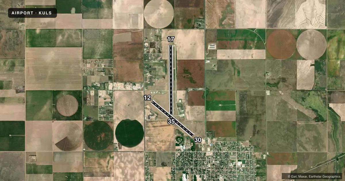
Runways & pattern
Full pagePattern entry · RWY 17
LEFT TRAFFIC| Runway | Heading (°M) | Length | Surface | Traffic |
|---|---|---|---|---|
| 17/35Favored | 174° / 354° | 6,000 ft | CONC | Standard L |
| 12/30 | 124° / 304° | 4,600 ft | CONC | Standard L |
Runway end performance
| End | TORA | TODA | ASDA | LDA | VGSI | Approach lights | Obstruction |
|---|---|---|---|---|---|---|---|
| 17 | — | — | — | — | PAPI 4-box left(3°) | — | 40', pline, 1400' from thr, 0' R of cntrln, slope 30 |
| 35 | — | — | — | — | PAPI 4-box left(3°) | — | — |
| 12 | — | — | — | — | PAPI 2-box left(3°) | — | 16', road, 700' from thr, 0' R of cntrln, slope 30 |
| 30 | — | — | — | — | PAPI 2-box left(3°) | — | 50', ant, 925' from thr, 315' R of cntrln, slope 14 |
Declared distances in feet. TORA = takeoff run available, TODA = takeoff distance, ASDA = accelerate-stop, LDA = landing distance.
Airport sketch
Runways drawn to scale from FAA survey coordinates, rendered over satellite imagery. Not for navigation.
Approaches & charts
Services on the field
Fuel grades, oxygen, maintenance, ramp storage and lighting — as declared to the FAA by the airport operator.
Fuel & services
- Fuel
- 100LLA
- Oxygen (bottled)
- Not available
- Oxygen (bulk)
- Not available
- Airframe repair
- Major
- Power plant repair
- Major
- Other services
- AGRI,INSTR,RNTL
Ramp & ground
- Transient storage
- Tie-down
- Hangar
- Landing fee
- No fee published
- Customs
- Not available
- Lighting schedule
- SEE RMK
- Beacon schedule
- SS-SR
- Beacon
- White / Green (civil land)(WG)
- Wind indicator
- Yes
- Segmented circle
- No
Fuel & FBOs
Cheapest 100LL and Jet A on the field and nearby. Always confirm with the FBO before taxi.
Airport notes
Surface conditions, obstructions, local procedures, lighting outages and other notes published with each FAA cycle.
General notes
- PUBLIC PHONE AVBL 24 HRS 620-356-9306.
- GLIDER & ULTRA LIGHT ACTIVITY ON & INVOF ARPT.
- FOR CD IF UNA TO CTC ON FSS FREQ, CTC KANSAS CITY ARTCC AT 913-254-8508.
Lighting notes
- ACTVT REIL RWY 17 & 35; PAPI RWY 12, 17, 30, & 35; MIRL RWYS 12/30 & 17/35 - CTAF.
Approach & departure obstructions
- 12ALSO 50 FT BLDG, 1420 FT DSTC, 310 FT R, 24:1.
VFR map & nearby airports
VFR sectional. Tap any ICAO chip to open that airport.
Key facts · KULS
Answer card- ICAO
- KULS
- Name
- ULYSSES
- Location
- ULYSSES, KANSAS
- Elevation
- 3,071 ft MSL
- Traffic pattern altitude
- 4,071 ft MSL (1,000 AGL)
- Control tower
- Non-towered (use CTAF)
- Total runways
- 2
- Longest runway
- 17/35 · 6,000 ft
- Published ILS approaches
- 0
- Published frequencies
- 2
- Magnetic variation
- 6°
- Current flight rules
- VFR
- Current wind
- 210° at 11 kt
- Favored runway now
- RWY 17
Ulysses Airport sits in Ulysses, Kansas. Field elevation is 3,071 ft MSL. The airport has two concrete runways. The longest is runway 17/35 at 6,000 ft. Runway 12/30 is 4,600 ft. There is no control tower. Use CTAF 122.8. The pattern altitude is not published, so plan on the standard 1,000 ft AGL for light piston traffic unless the current Chart Supplement says otherwise.
No ILS approaches are published here. That matters if you are planning an IFR arrival in lower weather. The runway lighting setup is good to know before a night arrival. Runway end identifier lights are active on 17 and 35. Medium intensity runway lights are installed on both runways. PAPI is installed on 12, 17, 30 and 35. Glider and ultralight activity also occurs on and near the airport. Keep your scan active in the pattern and on climbout.
North Star Aviation is on the field. It carries Jet A. For clearance delivery, if you cannot reach flight service on the usual frequency, Kansas City Center is listed in the remarks. There is also a public phone available 24 hours. One published obstruction note calls out a 50-foot building near the departure end of runway 12. Give that runway a careful look during planning and departure.