METAR & TAF 1K9
1K9 does not publish a METAR.
Showing the nearest reporting station: KULS (ULYSSES) · 20.5 NM away. Conditions at 1K9 may differ.
METAR · KULS
Observed 06:55Z
KULS 270655Z AUTO 17008KT 10SM CLR 29/13 A2991 RMK AO2
- Wind
- 170° @ 8 kt
- Visibility
- 10 SM
- Temp / Dew
- 29°C / 13°C
- Altimeter
- 29.91 inHg
- Clouds
- CLR
- Density alt
- 5,383 ft
- Ceiling
- Unlimited
- Rules
- VFR
Airport info & contacts
Manager on record, flight service, ARTCC, attendance schedule and pattern altitude — published by the FAA and refreshed every 28 days.
Location
- From city
- 1 NM N
- VFR sectional
- WICHITA
- ARTCC
- ZKC · KANSAS CITY
- NOTAM facility
- ICT (NOTAM-D)
Airport manager
- Name
- BILL ANTON
- Phone
- 620-649-7172
- Address
- 2268 ROAD II, SATANTA KS 67870
Flight service · Hours
- FSS ICT
- WICHITA1-800-WX-BRIEF
- Attendance
- Unattended
Frequencies
Tap any row to copy the frequency to your clipboard.
Runways & pattern
Full pagePattern entry · RWY 21
LEFT TRAFFICRunway end performance
| End | TORA | TODA | ASDA | LDA | VGSI | Approach lights | Obstruction |
|---|---|---|---|---|---|---|---|
| 21 | — | — | — | — | — | — | 15', road, 201' from thr, 125' R of cntrln, slope 0 |
Declared distances in feet. TORA = takeoff run available, TODA = takeoff distance, ASDA = accelerate-stop, LDA = landing distance.
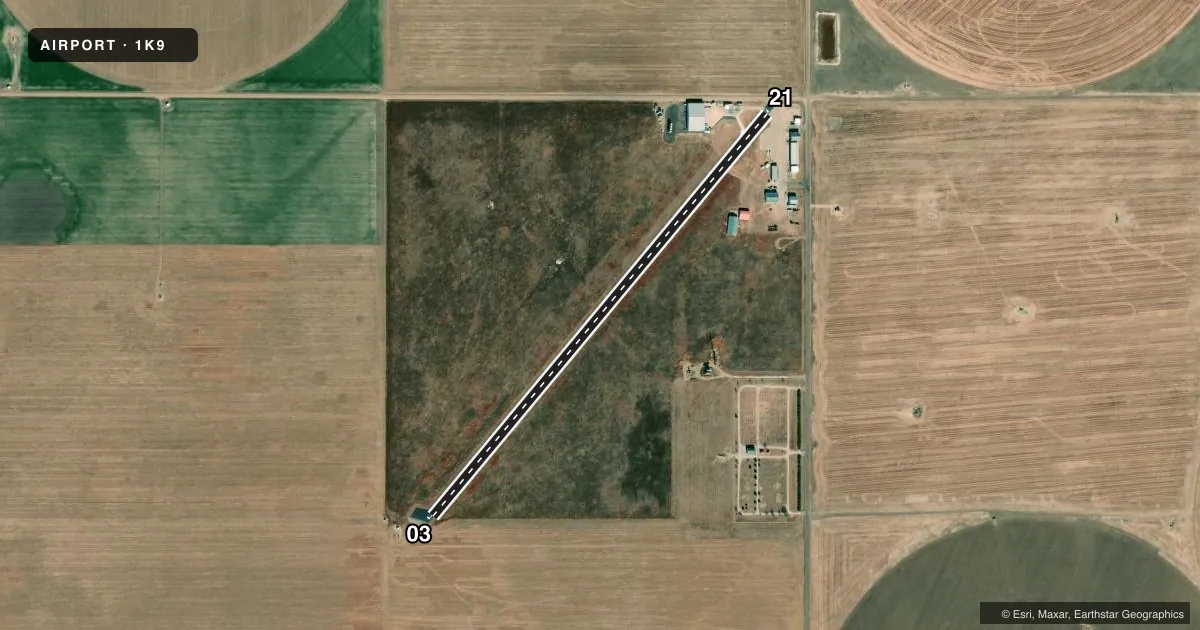
Airport sketch
Runways drawn to scale from FAA survey coordinates, rendered over satellite imagery. Not for navigation.
Approaches & charts
Services on the field
Fuel grades, oxygen, maintenance, ramp storage and lighting — as declared to the FAA by the airport operator.
Fuel & services
- Fuel
- 100LL
- Oxygen (bottled)
- Not available
- Oxygen (bulk)
- Not available
- Other services
- AGRI,INSTR,RNTL
Ramp & ground
- Transient storage
- Tie-down
- Hangar
- Landing fee
- No fee published
- Lighting schedule
- SS-SR
- Beacon schedule
- SS-SR
- Beacon
- White / Green (civil land)(WG)
- Wind indicator
- Lighted
- Segmented circle
- No
Fuel & FBOs
Cheapest 100LL and Jet A on the field and nearby. Always confirm with the FBO before taxi.
Airport notes
Surface conditions, obstructions, local procedures, lighting outages and other notes published with each FAA cycle.
General notes
- UNLGTD 200 FT ANT 7500 FT SW OF RWY 03.
- FOR CD CTC KANSAS CITY ARTCC AT 913-254-8508.
Fuel notes
- 100LLFUEL 24 HR SELF SVC.
Approach & departure obstructions
- 0315 FT OIL RIG 165 DSTC; 65 FT LEFT OF CNTRLN - LGTD.
- 2115 FT RD, 0-199 FT DSTC, 125 FT L/R.
- 03INTERSECTION OF 15 FT ROADS.
- 03OIL WELL 160 FT S OF RWY 03; GRAIN ELEVATORS 1 MI S; TWR 1 MI SW.
VFR map & nearby airports
VFR sectional. Tap any ICAO chip to open that airport.
Key facts · 1K9
Answer card- ICAO
- 1K9
- Name
- SATANTA MUNI
- Location
- SATANTA, KANSAS
- Elevation
- 2,976 ft MSL
- Traffic pattern altitude
- 3,976 ft MSL (1,000 AGL)
- Control tower
- Non-towered (use CTAF)
- Total runways
- 1
- Longest runway
- 03/21 · 3,250 ft
- Published ILS approaches
- 0
- Published frequencies
- 2
- Magnetic variation
- 9°
- Current flight rules
- VFR
- Current wind
- 170° at 8 kt
- Favored runway now
- RWY 21
Satanta Muni is in Satanta, Kansas. The field elevation is 2,976 ft MSL. It has one runway, 03/21, which is 3,250 ft long and asphalt. There is no control tower. CTAF and UNICOM are both 122.8.
No ILS approaches are published here. Pattern altitude is not published, so use the standard 1,000 ft AGL unless the current Chart Supplement says otherwise. That puts the light-piston pattern at 3,976 ft MSL based on the listed field elevation. The airport sits in open country, so the main thing to watch is the published obstacles near runway 03. There is an oil well south of the runway. There is a lighted oil rig close to the centerline. Grain elevators sit farther south. There is also a tower southwest of the field. An unlighted 200-foot antenna is well southwest of runway 03.
Corner Express is on the field. It carries 100LL. Fuel is available 24 hours by self-service. If you need clearance delivery, Kansas City ARTCC is listed in the remarks. For a first-time arrival, brief the runway 03 environment carefully and verify the current Chart Supplement before departure for any updates to local procedures or obstacle information.