METAR & TAF S44
S44 does not publish a METAR.
Showing the nearest reporting station: KLBL (LIBERAL MID-AMERICA RGNL) · 22.5 NM away. Conditions at S44 may differ.
METAR · KLBL
Observed 12:56Z
KLBL 271256Z AUTO 21011KT 10SM CLR 27/14 A2994 RMK AO2 SLP092 T02670144
- Wind
- 210° @ 11 kt
- Visibility
- 10 SM
- Temp / Dew
- 27°C / 14°C
- Altimeter
- 29.94 inHg
- Clouds
- CLR
- Density alt
- 4,840 ft
- Ceiling
- Unlimited
- Rules
- VFR
Airport info & contacts
Manager on record, flight service, ARTCC, attendance schedule and pattern altitude — published by the FAA and refreshed every 28 days.
Location
- From city
- 0 NM NE
- VFR sectional
- WICHITA
- ARTCC
- ZKC · KANSAS CITY
Airport manager
- Name
- JUNE BENDER
- Phone
- 620-563-7611
- Address
- CITY OF PLAINS 404 GRAND AVE, P O BOX 366, PLAINS KS 67869
Flight service · Hours
- FSS ICT
- WICHITA1-800-WX-BRIEF
- Attendance
- Unattended
Frequencies
Tap any row to copy the frequency to your clipboard.
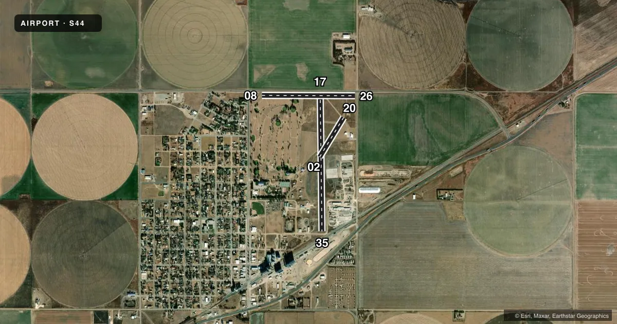
Runways & pattern
Full pagePattern entry · RWY 20
LEFT TRAFFIC| Runway | Heading (°M) | Length | Surface | Traffic |
|---|---|---|---|---|
| 17/35 | 170° / 350° | 3,350 ft | TURF | Standard L |
| 08/26 | 81° / 261° | 2,260 ft | TURF | Standard L |
| 02/20Favored | 22° / 202° | 1,120 ft | TURF | Standard L |
Runway end performance
| End | TORA | TODA | ASDA | LDA | VGSI | Approach lights | Obstruction |
|---|---|---|---|---|---|---|---|
| 17 | — | — | — | — | — | — | road, 300' from thr, slope 2 |
| 35 | — | — | — | — | — | — | rr, 350' from thr, slope 2 |
| 08 | — | — | — | — | — | — | bldg, 110' from thr, slope 11 |
| 26 | — | — | — | — | — | — | road, 15' from thr, slope 1 |
| 02 | — | — | — | — | — | — | bldg, 300' from thr, slope 2 |
| 20 | — | — | — | — | — | — | road, 25' from thr, slope 2 |
Declared distances in feet. TORA = takeoff run available, TODA = takeoff distance, ASDA = accelerate-stop, LDA = landing distance.
Airport sketch
Runways drawn to scale from FAA survey coordinates, rendered over satellite imagery. Not for navigation.
Approaches & charts
Services on the field
Fuel grades, oxygen, maintenance, ramp storage and lighting — as declared to the FAA by the airport operator.
Fuel & services
- Fuel
- Not available
- Oxygen (bottled)
- Not available
- Oxygen (bulk)
- Not available
- Airframe repair
- Not available
- Power plant repair
- Not available
Ramp & ground
- Transient storage
- Hangar
- Landing fee
- No fee published
- Customs
- Not available
- Wind indicator
- Yes
- Segmented circle
- No
Fuel & FBOs
Cheapest 100LL and Jet A on the field and nearby. Always confirm with the FBO before taxi.
Airport notes
Surface conditions, obstructions, local procedures, lighting outages and other notes published with each FAA cycle.
General notes
- FOR CD CTC KANSAS CITY ARTCC AT 913-254-8508.
Other notes
- PRVDD APCHS TO EA RWY END ARE MAINTD FOR A MIN 20:1 CLEAR GLIDE SLOPE; THAT A RGT TFC PATTERN IS ESTABD TO AVOID FLT OVER GRAIN ELEVATORS TO SW. CONTINUED-THAT A SEGMENTED CIRCLE IS INSTALLED AS A VISUAL AID TO INFORM PILOTS OF NONSTANDARD TFC PATTERN.
VFR map & nearby airports
VFR sectional. Tap any ICAO chip to open that airport.
Key facts · S44
Answer card- ICAO
- S44
- Name
- PLAINS MUNI
- Location
- PLAINS, KANSAS
- Elevation
- 2,762 ft MSL
- Traffic pattern altitude
- 3,762 ft MSL (1,000 AGL)
- Control tower
- Non-towered (use CTAF)
- Total runways
- 3
- Longest runway
- 17/35 · 3,350 ft
- Published ILS approaches
- 0
- Published frequencies
- 0
- Magnetic variation
- 9°
- Current flight rules
- VFR
- Current wind
- 210° at 11 kt
- Favored runway now
- RWY 20
Plains Muni sits in Plains, Kansas at 2,762 ft MSL. It has three turf runways. The longest is runway 17/35 at 3,350 ft. There is no control tower. No ILS approaches are published here. Pattern altitude is not published, so use the standard 1,000 ft AGL for light piston traffic unless the current Chart Supplement says otherwise.
This is a non-towered field with a nonstandard traffic pattern. A right traffic pattern is established to avoid flight over grain elevators to the southwest. A segmented circle is installed to help pilots sort out the pattern. The published remarks also say the runway ends are maintained with at least a 20 to 1 clear glide slope. That matters if you are planning a low approach or arriving with a heavy load. For clearance delivery, contact Kansas City ARTCC at 913-254-8508. There are no on-field FBOs listed in the facts, so confirm services with the airport operator or call ahead before you go.
The airport sits in open country with modest elevation, so expect a little more takeoff roll than you would at a lower field. With turf runways, surface condition can change fast after rain. Check the current Chart Supplement for any published local procedures before you fly in.