METAR & TAF 3KS
3KS does not publish a METAR.
Showing the nearest reporting station: KDDC (DODGE CITY RGNL) · 24.5 NM away. Conditions at 3KS may differ.
METAR · KDDC
Observed 12:52Z
KDDC 271252Z AUTO 21011KT 8SM CLR 27/15 A2989 RMK AO2 SLP081 T02670150
- Wind
- 210° @ 11 kt
- Visibility
- 8 SM
- Temp / Dew
- 27°C / 15°C
- Altimeter
- 29.89 inHg
- Clouds
- CLR
- Density alt
- 4,660 ft
- Ceiling
- Unlimited
- Rules
- VFR
Airport info & contacts
Manager on record, flight service, ARTCC, attendance schedule and pattern altitude — published by the FAA and refreshed every 28 days.
Location
- From city
- 6 NM NNW
- VFR sectional
- WICHITA
- ARTCC
- ZKC · KANSAS CITY
- NOTAM facility
- ICT
Airport manager
- Name
- THOMAS HUELSKAMP
- Phone
- 620-338-5920
- Address
- 36605 20 RD, FOWLER KS 67844
Flight service · Hours
- FSS ICT
- WICHITA1-800-WX-BRIEF
Frequencies
Tap any row to copy the frequency to your clipboard.
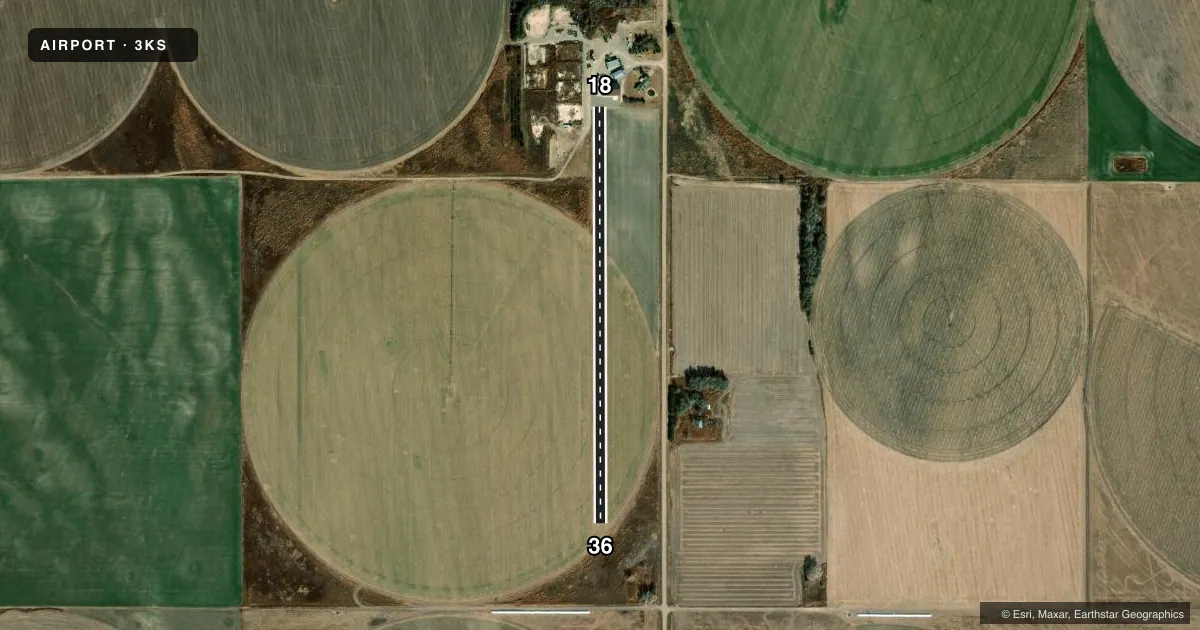
Runways & pattern
Full pagePattern entry · RWY 18
LEFT TRAFFICAirport sketch
Runways drawn to scale from FAA survey coordinates, rendered over satellite imagery. Not for navigation.
Approaches & charts
Services on the field
Fuel grades, oxygen, maintenance, ramp storage and lighting — as declared to the FAA by the airport operator.
Fuel & services
- Fuel
- Not available
Ramp & ground
- Transient storage
- Not published
Fuel & FBOs
Cheapest 100LL and Jet A on the field and nearby. Always confirm with the FBO before taxi.
Airport notes
Surface conditions, obstructions, local procedures, lighting outages and other notes published with each FAA cycle.
Other notes
- MANAGERTHUELS26@ICLOUD.COM
VFR map & nearby airports
VFR sectional. Tap any ICAO chip to open that airport.
Key facts · 3KS
Answer card- ICAO
- 3KS
- Name
- HF STRIP
- Location
- FOWLER, KANSAS
- Elevation
- 2,567 ft MSL
- Traffic pattern altitude
- 3,567 ft MSL (1,000 AGL)
- Control tower
- Non-towered (use CTAF)
- Total runways
- 1
- Longest runway
- 18/36 · 2,585 ft
- Published ILS approaches
- 0
- Published frequencies
- 1
- Magnetic variation
- –
- Current flight rules
- VFR
- Current wind
- 210° at 11 kt
- Favored runway now
- RWY 18
HF STRIP is in Fowler, Kansas. The field elevation is 2,567 ft MSL. It has one runway, 18/36, which is 2,585 ft of turf. The runway is the longest strip on the field. There is no control tower. CTAF is 122.9.
No ILS approaches are published here. Pattern altitude is not published, so plan on the standard 1,000 ft AGL for light piston operations unless the current Chart Supplement says otherwise. That puts the traffic pattern at about 3,567 ft MSL based on the listed field elevation. The published remarks say to contact the manager at THUELS26@ICLOUD.COM. There are no on-field FBOs listed. Verify services with the airport operator or call ahead before you go.
This is a small turf strip, so surface condition matters. Check the current Chart Supplement and get a local look at the runway before you commit, especially after rain or when the grass is soft. With no tower and no published ILS, this is a simple VFR planning airport. Use the CTAF early, keep your pattern tight and confirm the field is usable for your aircraft before departure.