METAR & TAF 8K8
8K8 does not publish a METAR.
Showing the nearest reporting station: KDDC (DODGE CITY RGNL) · 18.6 NM away. Conditions at 8K8 may differ.
METAR · KDDC
Observed 12:52Z
KDDC 271252Z AUTO 21011KT 8SM CLR 27/15 A2989 RMK AO2 SLP081 T02670150
- Wind
- 210° @ 11 kt
- Visibility
- 8 SM
- Temp / Dew
- 27°C / 15°C
- Altimeter
- 29.89 inHg
- Clouds
- CLR
- Density alt
- 4,887 ft
- Ceiling
- Unlimited
- Rules
- VFR
Airport info & contacts
Manager on record, flight service, ARTCC, attendance schedule and pattern altitude — published by the FAA and refreshed every 28 days.
Location
- From city
- 2 NM N
- VFR sectional
- WICHITA
- ARTCC
- ZKC · KANSAS CITY
- NOTAM facility
- ICT (NOTAM-D)
Airport manager
- Name
- SHANNON HOSKINSON
- Phone
- 620-855-2215
- Address
- PO BOX 467CIMARRON KS 67835
Flight service · Hours
- FSS ICT
- WICHITA1-800-WX-BRIEF
- Attendance
- Unattended
Frequencies
Tap any row to copy the frequency to your clipboard.
Runways & pattern
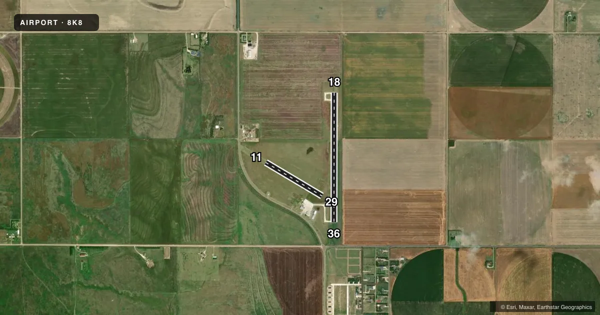
Full pagePattern entry · RWY 18
LEFT TRAFFIC| Runway | Heading (°M) | Length | Surface | Traffic |
|---|---|---|---|---|
| 18/36Favored | 171° / 351° | 3,200 ft | CONC | Standard L |
| 11/29 | 112° / 292° | 1,619 ft | TURF | Standard L |
Runway end performance
| End | TORA | TODA | ASDA | LDA | VGSI | Approach lights | Obstruction |
|---|---|---|---|---|---|---|---|
| 18 | — | — | — | — | PAPI 2-box left(3°) | — | — |
| 36 | — | — | — | — | PAPI 2-box left(3°) | — | — |
| 11 | — | — | — | — | — | — | pline, 20' from thr, 0' R of cntrln, slope 20 |
Declared distances in feet. TORA = takeoff run available, TODA = takeoff distance, ASDA = accelerate-stop, LDA = landing distance.
Airport sketch
Runways drawn to scale from FAA survey coordinates, rendered over satellite imagery. Not for navigation.
Approaches & charts
Services on the field
Fuel grades, oxygen, maintenance, ramp storage and lighting — as declared to the FAA by the airport operator.
Fuel & services
- Fuel
- 100LL
- Oxygen (bottled)
- Not available
- Oxygen (bulk)
- Not available
- Airframe repair
- Not available
- Power plant repair
- Not available
- Other services
- AGRI
Ramp & ground
- Transient storage
- Tie-down
- Landing fee
- No fee published
- Lighting schedule
- SEE RMK
- Beacon schedule
- SS-SR
- Beacon
- White / Green (civil land)(WG)
- Wind indicator
- Lighted
- Segmented circle
- No
Fuel & FBOs
Cheapest 100LL and Jet A on the field and nearby. Always confirm with the FBO before taxi.
Airport notes
Surface conditions, obstructions, local procedures, lighting outages and other notes published with each FAA cycle.
General notes
- FOR CD CTC KANSAS CITY ARTCC AT 913-254-8508.
- RWY 8/26 NOT MOWED. NOT INSPECTED.
Lighting notes
- ACTVT MIRL RWY 18/36 - CTAF.
Fuel notes
- 100LLSELF-SERVE.
Other notes
- PRVDD APCHS TO ARPT ARE MAINT FOR A MIN 20:1 GLIDE SLOPE AND TRSNL SFC MAINT FOR 7:1 SLOPE.
- MANAGER620-855-0114 MGR CELL.
- 11/29TURF ROUGH & UNEVEN WITH LOW SPOTS.
VFR map & nearby airports
VFR sectional. Tap any ICAO chip to open that airport.
Key facts · 8K8
Answer card- ICAO
- 8K8
- Name
- CIMARRON MUNI
- Location
- CIMARRON, KANSAS
- Elevation
- 2,749.5 ft MSL
- Traffic pattern altitude
- 3,749.5 ft MSL (1,000 AGL)
- Control tower
- Non-towered (use CTAF)
- Total runways
- 2
- Longest runway
- 18/36 · 3,200 ft
- Published ILS approaches
- 0
- Published frequencies
- 1
- Magnetic variation
- 9°
- Current flight rules
- VFR
- Current wind
- 210° at 11 kt
- Favored runway now
- RWY 18
Cimarron Muni (8K8) sits in Cimarron, Kansas. Field elevation is 2,749.5 ft MSL. The airport has two runways. The longest is 18/36 at 3,200 ft on concrete. Runway 11/29 is 1,619 ft of turf. The field is non-towered. CTAF is 122.9.
No ILS approaches are published here. Pattern altitude is not published. Use the standard 1,000 ft AGL pattern for light piston aircraft unless the current Chart Supplement says otherwise. For this field that works out to about 3,749.5 ft MSL. Runway 18/36 has medium intensity lights that are activated by CTAF. Runway 11/29 is reported as rough and uneven with low spots. Runway 8/26 is not mowed and not inspected.
There are no on-field FBOs listed in the facts. 100LL is available as self-serve fuel. For clearance delivery, contact Kansas City ARTCC at 913-254-8508. The airport manager can be reached at 620-855-0114. The published approach notes mention obstacle clearance surfaces maintained to standard slopes. That is a good reminder to stay current on the Chart Supplement before you go. This is a high-elevation Kansas field. Expect more density altitude effect on takeoff and climb performance than you would at lower fields.