METAR & TAF K79
K79 does not publish a METAR.
Showing the nearest reporting station: KDDC (DODGE CITY RGNL) · 13.7 NM away. Conditions at K79 may differ.
METAR · KDDC
Observed 02:52Z
KDDC 270252Z AUTO 17012G19KT 9SM CLR 32/17 A2988 RMK AO2 SLP075 T03220172 53005 $
- Wind
- 170° @ 12G19 kt
- Visibility
- 9 SM
- Temp / Dew
- 32°C / 17°C
- Altimeter
- 29.88 inHg
- Clouds
- CLR
- Density alt
- 5,149 ft
- Ceiling
- Unlimited
- Rules
- VFR
Airport info & contacts
Manager on record, flight service, ARTCC, attendance schedule and pattern altitude — published by the FAA and refreshed every 28 days.
Location
- From city
- 6 NM S
- VFR sectional
- WICHITA
- ARTCC
- ZKC · KANSAS CITY
- NOTAM facility
- ICT (NOTAM-D)
Airport manager
- Name
- MICHAEL ORT
- Phone
- 620-393-5565
- Address
- 109 E BRIMLEY, BOX 8, JETMORE KS 67854
Flight service · Hours
- FSS ICT
- WICHITA1-800-WX-BRIEF
- Attendance
- Unattended
Frequencies
Tap any row to copy the frequency to your clipboard.
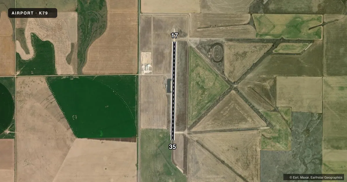
Runways & pattern
Full pagePattern entry · RWY 17
LEFT TRAFFICAirport sketch
Runways drawn to scale from FAA survey coordinates, rendered over satellite imagery. Not for navigation.
Approaches & charts
Services on the field
Fuel grades, oxygen, maintenance, ramp storage and lighting — as declared to the FAA by the airport operator.
Fuel & services
- Fuel
- Not available
- Airframe repair
- Not available
- Power plant repair
- Not available
Ramp & ground
- Transient storage
- Tie-down
- Landing fee
- No fee published
- Customs
- Not available
- Lighting schedule
- SEE RMK
- Beacon schedule
- SS-SR
- Beacon
- White / Green (civil land)(WG)
- Wind indicator
- Yes
- Segmented circle
- No
Fuel & FBOs
Cheapest 100LL and Jet A on the field and nearby. Always confirm with the FBO before taxi.
Airport notes
Surface conditions, obstructions, local procedures, lighting outages and other notes published with each FAA cycle.
General notes
- FOR CD CTC KANSAS CITY ARTCC AT 913-254-8508.
Lighting notes
- LIRL RWY 17/35 PRESET LOW INTST; CONT NGT.
Runway surface & condition
- 17/35RWY 17/35 NSTD LIRL DUE TO SPACING & NUMBER OF LGTS.
Other notes
- EXISTED PRIOR TO 1959.
- MANAGERCITY SUPERINTENDENT.
- 17/35EXTENSIVE CRACKING.
VFR map & nearby airports
VFR sectional. Tap any ICAO chip to open that airport.
Key facts · K79
Answer card- ICAO
- K79
- Name
- JETMORE MUNI
- Location
- JETMORE, KANSAS
- Elevation
- 2,467 ft MSL
- Traffic pattern altitude
- 3,467 ft MSL (1,000 AGL)
- Control tower
- Non-towered (use CTAF)
- Total runways
- 1
- Longest runway
- 17/35 · 4,205 ft
- Published ILS approaches
- 0
- Published frequencies
- 2
- Magnetic variation
- 8°
- Current flight rules
- VFR
- Current wind
- 170° at 12 kt
- Favored runway now
- RWY 17
Jetmore Muni sits in Jetmore, Kansas. The field elevation is 2,467 ft MSL. It has one runway. Runway 17/35 is 4,205 ft long with asphalt-concrete pavement. The runway headings are 181° and 1° magnetic. No tower is published here. CTAF and UNICOM are both 122.7. No ILS approaches are published for the field.
Pattern altitude is not published. Use 1,000 ft AGL for light piston traffic unless the current Chart Supplement says otherwise. At this elevation, expect a little more takeoff roll and a little less climb than you would at a lower field. The runway lighting is low-intensity. It is preset to low intensity and runs continuously at night. The published remarks also note extensive cracking on Runway 17/35. Plan for a careful surface check on taxi, takeoff and landing.
There are no on-field FBOs listed in the facts. Contact the airport operator directly before arrival if you need fuel or local services. For clearance delivery, Kansas City ARTCC is the published contact. The airport manager is the city superintendent. If you are filing IFR or planning a night arrival, verify the current Chart Supplement before you go.