METAR & TAF 48K
48K does not publish a METAR.
Showing the nearest reporting station: KHYS (HAYS RGNL) · 37.1 NM away. Conditions at 48K may differ.
METAR · KHYS
Observed 12:56Z
KHYS 271256Z AUTO 20008KT 6SM HZ CLR 26/17 A2983 RMK AO2 SLP077 T02560167 $
- Wind
- 200° @ 8 kt
- Visibility
- 6 SM
- Temp / Dew
- 26°C / 17°C
- Altimeter
- 29.83 inHg
- Clouds
- CLR
- Density alt
- 4,310 ft
- Ceiling
- Unlimited
- Rules
- VFR
Airport info & contacts
Manager on record, flight service, ARTCC, attendance schedule and pattern altitude — published by the FAA and refreshed every 28 days.
Location
- From city
- 1 NM N
- VFR sectional
- WICHITA
- ARTCC
- ZKC · KANSAS CITY
- NOTAM facility
- ICT (NOTAM-D)
Airport manager
- Name
- TRAVIS SNYDER
- Phone
- 785-798-5808
- Address
- CITY BLDG 208 W MAIN ST, BOX 419, NESS CITY KS 67560
Flight service · Hours
- FSS ICT
- WICHITA1-800-WX-BRIEF
- Attendance
- Unattended
Frequencies
Tap any row to copy the frequency to your clipboard.
Runways & pattern
Full pagePattern entry · RWY 17
LEFT TRAFFICRunway end performance
| End | TORA | TODA | ASDA | LDA | VGSI | Approach lights | Obstruction |
|---|---|---|---|---|---|---|---|
| 17 | 4,000' | 4,000' | 4,000' | 4,000' | PAPI 2-box left(3°) | — | — |
| 35 | 4,000' | 4,000' | 4,000' | 4,000' | PAPI 2-box left(3°) | — | — |
Declared distances in feet. TORA = takeoff run available, TODA = takeoff distance, ASDA = accelerate-stop, LDA = landing distance.
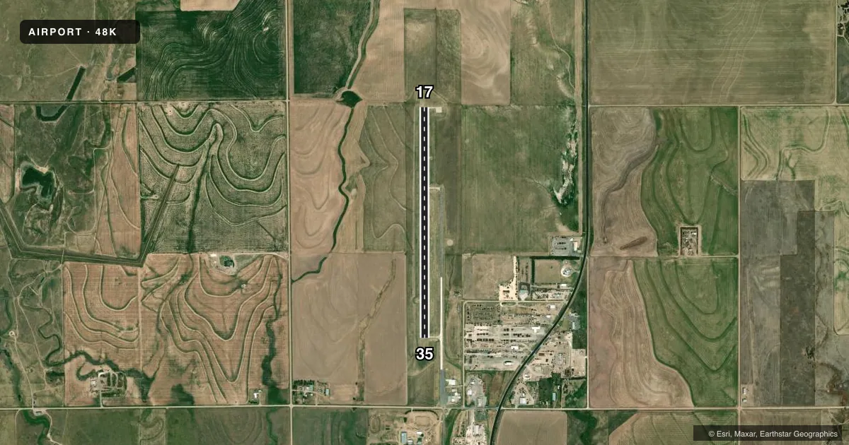
Airport sketch
Runways drawn to scale from FAA survey coordinates, rendered over satellite imagery. Not for navigation.
Approaches & charts
Services on the field
Fuel grades, oxygen, maintenance, ramp storage and lighting — as declared to the FAA by the airport operator.
Fuel & services
- Fuel
- Not available
- Oxygen (bottled)
- Not available
- Oxygen (bulk)
- Not available
- Airframe repair
- Not available
- Power plant repair
- Not available
- Other services
- AGRI
Ramp & ground
- Transient storage
- Tie-down
- Landing fee
- No fee published
- Lighting schedule
- SEE RMK
- Beacon schedule
- SS-SR
- Beacon
- White / Green (civil land)(WG)
- Wind indicator
- Lighted
- Segmented circle
- Yes
Fuel & FBOs
Cheapest 100LL and Jet A on the field and nearby. Always confirm with the FBO before taxi.
Airport notes
Surface conditions, obstructions, local procedures, lighting outages and other notes published with each FAA cycle.
General notes
- PUBLIC PHONE AVBL 785-798-2702.
- FOR CD CTC KANSAS CITY ARTCC AT 913-254-8508.
Lighting notes
- ACTVT REIL RWY 17 & 35, PAPI RWY 17 & 35, MIRL RWY 17/35 - CTAF.
Other notes
- PROVIDED A CLEAR APPROACH TO EACH RWY IS MAINTAINED FOR A MINIMUM 20:1 GLIDE SLOPE AND THE TRANSITIONAL SURFACE IS MAINTAINED FOR A 7:1 SLOPE.
VFR map & nearby airports
VFR sectional. Tap any ICAO chip to open that airport.
Key facts · 48K
Answer card- ICAO
- 48K
- Name
- NESS CITY MUNI
- Location
- NESS CITY, KANSAS
- Elevation
- 2,321.6 ft MSL
- Traffic pattern altitude
- 3,321.6 ft MSL (1,000 AGL)
- Control tower
- Non-towered (use CTAF)
- Total runways
- 1
- Longest runway
- 17/35 · 4,000 ft
- Published ILS approaches
- 0
- Published frequencies
- 1
- Magnetic variation
- 8°
- Current flight rules
- VFR
- Current wind
- 200° at 8 kt
- Favored runway now
- RWY 17
Ness City Muni (48K) sits in Ness City, Kansas. Field elevation is 2,321.6 ft MSL. The airport has one runway. Runway 17/35 is 4,000 ft long with a concrete surface. There is no control tower. CTAF is 122.9.
No ILS approaches are published here. The pattern altitude is not published in the facts, so use the standard 1,000 ft AGL for light piston operations unless the current Chart Supplement says otherwise. At this elevation, expect a little more takeoff and climb performance planning than you would at a low field. The published remarks also note runway end identifier lights, PAPI on both ends and medium intensity runway lights on 17/35. All lighting is controlled by CTAF. That makes it important to brief your lighting plan before you get there.
There are no on-field FBOs listed in the facts. If you need fuel or ramp details, contact the airport operator or call the field directly before arrival. A public phone is available at 785-798-2702. For clearance delivery, contact Kansas City ARTCC at 913-254-8508. The published remarks also say a clear approach is maintained to each runway with a 20 to 1 glide slope and a 7 to 1 transitional surface. That is worth keeping in mind on arrival and departure.