METAR & TAF 0H1
0H1 does not publish a METAR.
Showing the nearest reporting station: KHLC (HILL CITY MUNI) · 22.6 NM away. Conditions at 0H1 may differ.
METAR · KHLC
Observed 01:53Z
KHLC 170153Z AUTO 03022G44KT 6SM -TSRA FEW047 SCT080 BKN100 28/07 A2953 RMK AO2 PK WND 04044/0151 LTG DSNT ALQDS RAB43 TSB45 SLP974 P0001 T02830072
- Wind
- 030° @ 22G44 kt
- Visibility
- 6 SM
- Temp / Dew
- 28°C / 7°C
- Altimeter
- 29.53 inHg
- Clouds
- BKN
- Density alt
- 5,068 ft
- Ceiling
- 10,000 ft AGL
- Rules
- VFR
Airport info & contacts
Manager on record, flight service, ARTCC, attendance schedule and pattern altitude — published by the FAA and refreshed every 28 days.
Location
- From city
- 2 NM SW
- VFR sectional
- WICHITA
- ARTCC
- ZDV · DENVER
- NOTAM facility
- ICT (NOTAM-D)
Airport manager
- Name
- LORI AUGUSTINE - COUNTY CLERK
- Phone
- 785-743-5773
- Address
- WAKEENEY KS 67672
Flight service · Hours
- FSS ICT
- WICHITA1-800-WX-BRIEF
- Attendance
- Unattended
Frequencies
Tap any row to copy the frequency to your clipboard.
Runways & pattern
Full pagePattern entry · RWY 35
LEFT TRAFFICRunway end performance
| End | TORA | TODA | ASDA | LDA | VGSI | Approach lights | Obstruction |
|---|---|---|---|---|---|---|---|
| 17 | — | — | — | — | — | — | 58', pole, 1107' from thr, 40' R of cntrln, slope 15 |
Declared distances in feet. TORA = takeoff run available, TODA = takeoff distance, ASDA = accelerate-stop, LDA = landing distance.
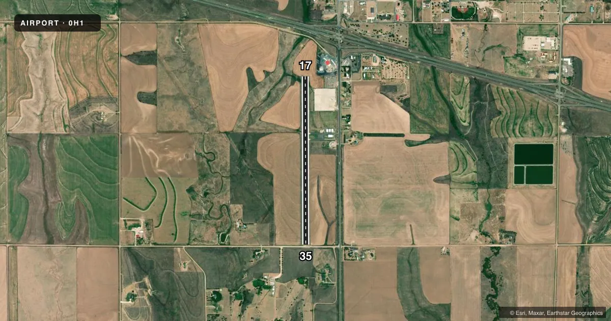
Airport sketch
Runways drawn to scale from FAA survey coordinates, rendered over satellite imagery. Not for navigation.
Approaches & charts
Services on the field
Fuel grades, oxygen, maintenance, ramp storage and lighting — as declared to the FAA by the airport operator.
Fuel & services
- Fuel
- Not available
- Power plant repair
- Minor
- Other services
- AGRI,INSTR
Ramp & ground
- Transient storage
- Tie-down
- Landing fee
- No fee published
- Lighting schedule
- SEE RMK
- Beacon
- White / Green (civil land)(WG)
- Wind indicator
- Lighted
- Segmented circle
- No
Fuel & FBOs
Cheapest 100LL and Jet A on the field and nearby. Always confirm with the FBO before taxi.
Airport notes
Surface conditions, obstructions, local procedures, lighting outages and other notes published with each FAA cycle.
General notes
- FOR CD CTC DENVER ARTCC AT 303-651-4257.
- RWY 17/35 MIDFIELD, FOUR 5 FT PLASTIC POLES MARK PIPELINE, 50 FT FM RWY CL.
- RWY 17 END, 20 ACRE LIGHTED TRUCK PARKING AREA, 185 FT E OF RWY EDGE EDGE.
- RWY 35, 21 INCH CONCRETE LIGHT BASES, 28 FT FROM W. RWY EDGE, 1300 FM RWY END.
Lighting notes
- ACTVT LIRL 17/35 - CTAF
Approach & departure obstructions
- 3511 FT RD, 27 FT DSTC, 125 FT L/R.
- 35APCH SLOPE 36:1 TO DTHR.
- 17APCH SLOPE 36:1 TO DTHR. DTHR MKD/LGTD 462 FT FM RWY END.
Other notes
- PRVDD EACH APCH IS MAINT FOR MIN 20:1 GLIDE SLOPE & TRSNL SFC MAINT FOR 7:1 SLOPE.
- 1FOR SVC CALL 785-743-8344.
- MANAGERCOUNTY CLERK/INTERIM AMGR.
- OWNERLORI.AUGUSTINE@TREGOCOUNTYKS.GOV
VFR map & nearby airports
VFR sectional. Tap any ICAO chip to open that airport.
Key facts · 0H1
Answer card- ICAO
- 0H1
- Name
- TREGO WAKEENEY
- Location
- WAKEENEY, KANSAS
- Elevation
- 2,438.9 ft MSL
- Traffic pattern altitude
- 3,438.9 ft MSL (1,000 AGL)
- Control tower
- Non-towered (use CTAF)
- Total runways
- 1
- Longest runway
- 17/35 · 4,008 ft
- Published ILS approaches
- 0
- Published frequencies
- 1
- Magnetic variation
- 5°
- Current flight rules
- VFR
- Current wind
- 030° at 22 kt
- Favored runway now
- RWY 35
Trego Wakeeney Airport sits in Wakeeney, Kansas. The field elevation is 2,438.9 ft MSL. It has one runway. Runway 17/35 is 4,008 ft long and paved with concrete. There is no control tower. CTAF is 122.9. Low intensity runway lighting on 17/35 is activated by CTAF.
No ILS approaches are published here. The pattern altitude is not published, so use the standard 1,000 ft AGL for light piston operations unless the current FAA Chart Supplement says otherwise. That puts the working pattern at 3,438.9 ft MSL based on the listed field elevation. The runway environment has a few items worth brief attention. Runway 17 has a marked and lighted threshold that is displaced 462 ft from the runway end. Runway 35 has an 11-foot road near the approach area. There are also 21-inch concrete light bases near the west edge of runway 35. Four 5-foot plastic poles mark a pipeline at midfield.
No on-field FBOs are listed. For service, call the airport at 785-743-8344. The airport manager is the county clerk and interim manager. For clearance delivery, contact Denver ARTCC at 303-651-4257. If you need current noise, access, or operational guidance, check the current FAA Chart Supplement or call the airport operator directly before you go.