METAR & TAF 1F5
1F5 does not publish a METAR.
Showing the nearest reporting station: KOEL (OAKLEY MUNI) · 23.3 NM away. Conditions at 1F5 may differ.
METAR · KOEL
Observed 11:55Z
KOEL 271155Z AUTO 23004KT 10SM CLR 23/14 A2987 RMK AO1 T02250139 10287 20225
- Wind
- 230° @ 4 kt
- Visibility
- 10 SM
- Temp / Dew
- 23°C / 14°C
- Altimeter
- 29.87 inHg
- Clouds
- CLR
- Density alt
- 4,411 ft
- Ceiling
- Unlimited
- Rules
- VFR
Airport info & contacts
Manager on record, flight service, ARTCC, attendance schedule and pattern altitude — published by the FAA and refreshed every 28 days.
Location
- From city
- 0 NM N
- VFR sectional
- WICHITA
- ARTCC
- ZDV · DENVER
- NOTAM facility
- ICT (NOTAM-D)
Airport manager
- Name
- WAYNE RANEY
- Phone
- 785-675-3988
- Address
- 829 MAIN ST, P O BOX 898, HOXIE KS 67740
Flight service · Hours
- FSS ICT
- WICHITA1-800-WX-BRIEF
- Attendance
- Unattended
Frequencies
Tap any row to copy the frequency to your clipboard.
Runways & pattern
Full pagePattern entry · RWY 26
LEFT TRAFFICRunway end performance
| End | TORA | TODA | ASDA | LDA | VGSI | Approach lights | Obstruction |
|---|---|---|---|---|---|---|---|
| 08 | — | — | — | — | — | — | 17', road, 180' from thr, 0' R of cntrln, slope 10 |
Declared distances in feet. TORA = takeoff run available, TODA = takeoff distance, ASDA = accelerate-stop, LDA = landing distance.
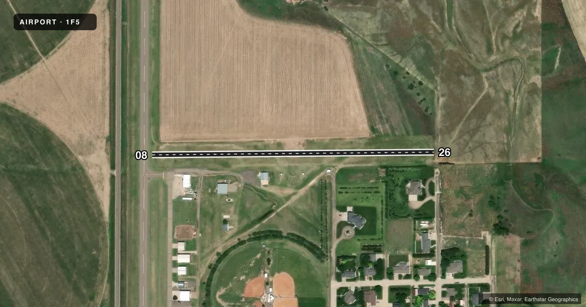
Airport sketch
Runways drawn to scale from FAA survey coordinates, rendered over satellite imagery. Not for navigation.
Approaches & charts
Services on the field
Fuel grades, oxygen, maintenance, ramp storage and lighting — as declared to the FAA by the airport operator.
Fuel & services
- Fuel
- Not available
- Airframe repair
- Not available
- Power plant repair
- Not available
- Other services
- AGRI
Ramp & ground
- Transient storage
- Tie-down
- Landing fee
- No fee published
- Lighting schedule
- SEE RMK
- Beacon
- White / Green (civil land)(WG)
- Wind indicator
- Lighted
- Segmented circle
- No
Fuel & FBOs
Cheapest 100LL and Jet A on the field and nearby. Always confirm with the FBO before taxi.
Airport notes
Surface conditions, obstructions, local procedures, lighting outages and other notes published with each FAA cycle.
General notes
- FOR CD CTC DENVER ARTCC AT 303-651-4257.
Lighting notes
- ACTVT MIRL RWY 17/35 - CTAF.
Runway surface & condition
- 08/26CLSD, NOT INSP.
Approach & departure obstructions
- 174 FT FENCE 0-160 FT DSTC, 108 R - 105 L.
- 3510 FT POST, 171 FT DSTC, 90 L, 10 FT SIGN, 158 FT DSTC, 135 FT L. 4 FT FENCE, 162 FT DSTC, 125 FT L/R.
- 1715 FT HWY PARALLEL TO HWY, 146 FT W OF RCL.
Other notes
- EXISTED PRIOR TO 1959.
VFR map & nearby airports
VFR sectional. Tap any ICAO chip to open that airport.
Key facts · 1F5
Answer card- ICAO
- 1F5
- Name
- HOXIE-SHERIDAN COUNTY
- Location
- HOXIE, KANSAS
- Elevation
- 2,733 ft MSL
- Traffic pattern altitude
- 3,733 ft MSL (1,000 AGL)
- Control tower
- Non-towered (use CTAF)
- Total runways
- 1
- Longest runway
- 08/26 · 1,750 ft
- Published ILS approaches
- 0
- Published frequencies
- 1
- Magnetic variation
- 9°
- Current flight rules
- VFR
- Current wind
- 230° at 4 kt
- Favored runway now
- RWY 26
Hoxie-Sheridan County Airport sits in Hoxie, Kansas. The field elevation is 2,733 ft MSL. It has one runway. The longest runway listed is 1,750 ft of turf. The published runway 08/26 is closed and not inspected, so check current field status before you go. This leaves runway 17/35 as the active runway listed in the remarks. The airport is not towered. CTAF is 122.9. Medium intensity runway lights on 17/35 are activated by CTAF.
No ILS approaches are published here. Pattern altitude is not published in the Chart Supplement. Use the standard 1,000 ft AGL pattern for light piston operations unless the current Chart Supplement says otherwise. The field sits at higher elevation for the region, so performance planning matters on warm days. Published remarks also note obstructions near both runway ends. There is a fence near the 17 end. There are posts, a sign and a fence near the 35 end. There is also a highway near the 17 end. There are no on-field FBOs listed, so plan fuel and services before arrival. Verify current availability with the airport operator or the FBO directly by phone.