METAR & TAF KOEL
Current METAR
Observed 13:15Z
KOEL 271315Z AUTO 35006KT 10SM CLR 27/13 A2989 RMK AO1 T02740129
- Wind
- 350° @ 6 kt
- Visibility
- 10 SM
- Temp / Dew
- 27°C / 13°C
- Altimeter
- 29.89 inHg
- Clouds
- CLR
- Density alt
- 5,253 ft
- Ceiling
- Unlimited
- Rules
- VFR
Airport info & contacts
Manager on record, flight service, ARTCC, attendance schedule and pattern altitude — published by the FAA and refreshed every 28 days.
Location
- From city
- 2 NM SE
- VFR sectional
- WICHITA
- ARTCC
- ZDV · DENVER
- NOTAM facility
- ICT (NOTAM-D)
Airport manager
- Name
- JOHN HOLZMEISTER
- Phone
- 785-672-0147
- Address
- CITY HALL, 209 HUDSON AVE, OAKLEY KS 67748-6016
Flight service · Hours
- FSS ICT
- WICHITA1-800-WX-BRIEF
- Attendance
- MON-FRI · 0800-1700
Frequencies
Tap any row to copy the frequency to your clipboard.
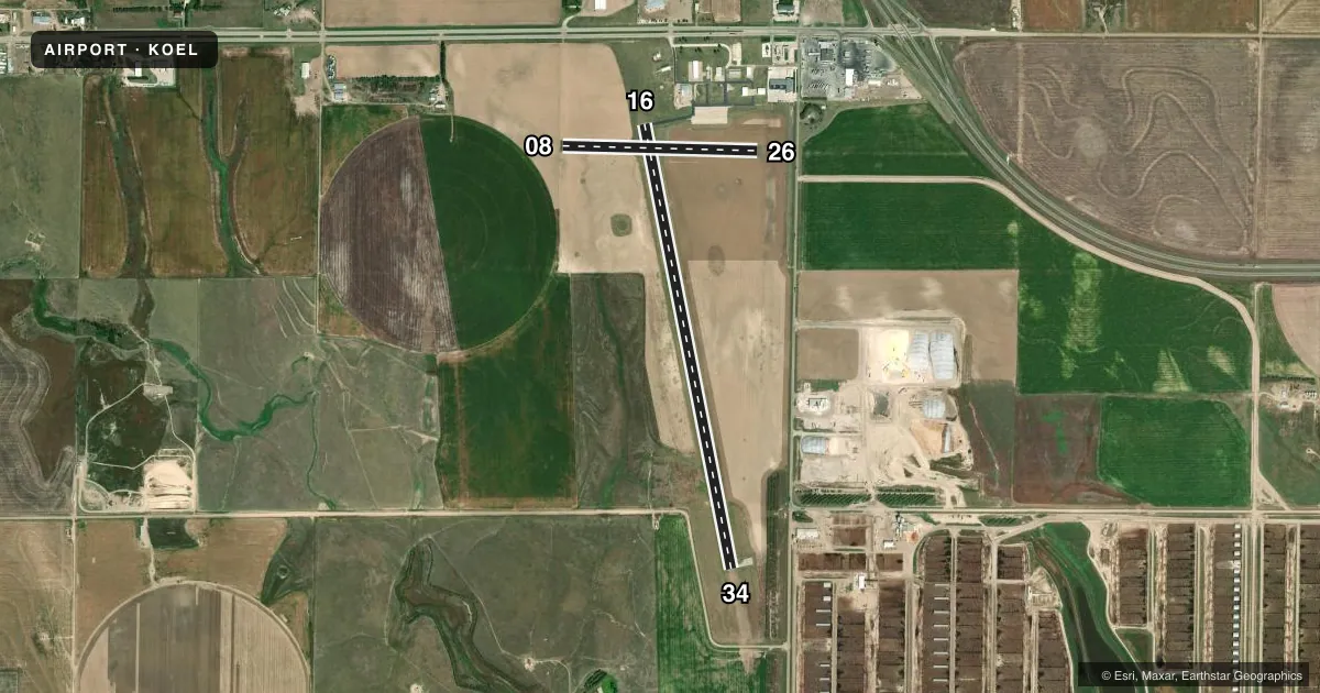
Runways & pattern
Full pagePattern entry · RWY 34
LEFT TRAFFIC| Runway | Heading (°M) | Length | Surface | Traffic |
|---|---|---|---|---|
| 16/34Favored | 161° / 341° | 5,000 ft | CONC | Standard L |
| 08/26 | 83° / 263° | 2,153 ft | TURF | Standard L |
Runway end performance
| End | TORA | TODA | ASDA | LDA | VGSI | Approach lights | Obstruction |
|---|---|---|---|---|---|---|---|
| 16 | 5,000' | 5,000' | 5,000' | 5,000' | PAPI 2-box left(3°) | — | 20', bldg, 670' from thr, 280' R of cntrln, slope 23 |
| 34 | 5,000' | 5,000' | 5,000' | 5,000' | PAPI 2-box left(3°) | — | — |
| 26 | — | — | — | — | — | — | 14', road, 375' from thr, 145' R of cntrln, slope 26 |
Declared distances in feet. TORA = takeoff run available, TODA = takeoff distance, ASDA = accelerate-stop, LDA = landing distance.
Airport sketch
Runways drawn to scale from FAA survey coordinates, rendered over satellite imagery. Not for navigation.
Approaches & charts
Services on the field
Fuel grades, oxygen, maintenance, ramp storage and lighting — as declared to the FAA by the airport operator.
Fuel & services
- Fuel
- 100LLAA1+
- Airframe repair
- Major
- Power plant repair
- Major
- Other services
- AGRI,INSTR
Ramp & ground
- Transient storage
- Tie-down
- Hangar
- Landing fee
- No fee published
- Customs
- Not available
- Lighting schedule
- SEE RMK
- Beacon schedule
- SS-SR
- Beacon
- White / Green (civil land)(WG)
- Wind indicator
- Lighted
- Segmented circle
- Yes
Fuel & FBOs
Cheapest 100LL and Jet A on the field and nearby. Always confirm with the FBO before taxi.
Airport notes
Surface conditions, obstructions, local procedures, lighting outages and other notes published with each FAA cycle.
General notes
- FUEL H24 SELF SVC.
- SVC AFTER HR - 785-672-0147.
- FOR CD CTC DENVER ARTCC AT 303-651-4257.
Lighting notes
- ACTVT REIL RWY 16 & 34; PAPI RWY 16 & 34; MIRL RWY 16/34 - CTAF.
Approach & departure obstructions
- 16PAPI UNUSBL BYD 8 DEG RIGHT & 6 DEG LEFT OF CNTRLN.
- 34PAPI UNUSBL BYD 8 DEG LEFT OF CNTRLN.
VFR map & nearby airports
VFR sectional. Tap any ICAO chip to open that airport.
Key facts · KOEL
Answer card- ICAO
- KOEL
- Name
- OAKLEY MUNI
- Location
- OAKLEY, KANSAS
- Elevation
- 3,045.2 ft MSL
- Traffic pattern altitude
- 4,045.2 ft MSL (1,000 AGL)
- Control tower
- Non-towered (use CTAF)
- Total runways
- 2
- Longest runway
- 16/34 · 5,000 ft
- Published ILS approaches
- 0
- Published frequencies
- 2
- Magnetic variation
- 8°
- Current flight rules
- VFR
- Current wind
- 350° at 6 kt
- Favored runway now
- RWY 34
Oakley Muni (KOEL) sits in Oakley, Kansas. The field elevation is 3,045.2 ft MSL. It has two runways. The longest is runway 16/34 at 5,000 ft of concrete. Runway 08/26 is a 2,153 ft turf strip. There is no control tower. CTAF and UNICOM are both 122.8. No ILS approaches are published here.
Pattern altitude is not published. Use the standard 1,000 ft AGL for light piston operations unless the current Chart Supplement says otherwise. That puts you at about 4,045 ft MSL on a normal pattern day. A+ Aviation Services is on the field. It carries 100LL and Jet A Prist. Fuel is also available 24 hours a day self-serve. After-hours service is available by calling the number in the Chart Supplement.
Runways 16 and 34 have lights, REILs and PAPI. The PAPI on 16 has a limited usable viewing angle. The PAPI on 34 does too. This is a high-elevation field on the plains. Expect performance to matter on warm days. If you need clearance delivery, contact Denver ARTCC before departure. Check the current Chart Supplement for any published noise or curfew restrictions before flying into the field.