METAR & TAF KTQK
Current METAR
Observed 12:55Z
KTQK 271255Z AUTO 20007KT 10SM CLR 24/16 A2990 RMK AO2 T02360156
- Wind
- 200° @ 7 kt
- Visibility
- 10 SM
- Temp / Dew
- 24°C / 16°C
- Altimeter
- 29.90 inHg
- Clouds
- CLR
- Density alt
- 4,786 ft
- Ceiling
- Unlimited
- Rules
- VFR
Airport info & contacts
Manager on record, flight service, ARTCC, attendance schedule and pattern altitude — published by the FAA and refreshed every 28 days.
Location
- From city
- 1 NM SE
- VFR sectional
- WICHITA
- ARTCC
- ZDV · DENVER
- NOTAM facility
- ICT (NOTAM-D)
Airport manager
- Name
- WARREN HARKNESS
- Phone
- (620) 872-5620
- Address
- 300 SOUTH MESQUITE ROAD, SCOTT CITY KS 67871
Flight service · Hours
- FSS ICT
- WICHITA1-800-WX-BRIEF
- Attendance
- 0800-1730
Frequencies
Tap any row to copy the frequency to your clipboard.
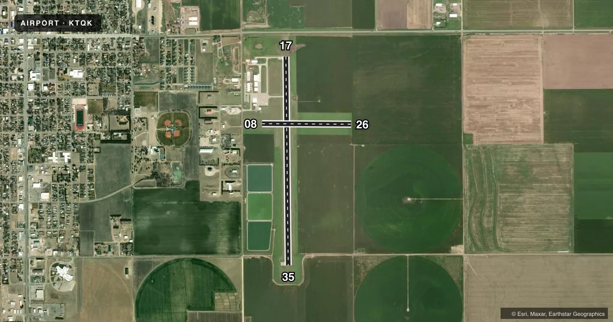
Runways & pattern
Full pagePattern entry · RWY 17
LEFT TRAFFIC| Runway | Heading (°M) | Length | Surface | Traffic |
|---|---|---|---|---|
| 17/35Favored | 171° / 351° | 5,002 ft | CONC | Standard L |
| 08/26 | 82° / 262° | 2,145 ft | TURF | Standard L |
Runway end performance
| End | TORA | TODA | ASDA | LDA | VGSI | Approach lights | Obstruction |
|---|---|---|---|---|---|---|---|
| 17 | — | — | — | — | PAPI 2-box left(3°) | — | 15', road, 530' from thr, 0' R of cntrln, slope 22 |
| 35 | — | — | — | — | PAPI 2-box left(3°) | — | 10', road, 201' from thr, 283' R of cntrln, slope 0 |
Declared distances in feet. TORA = takeoff run available, TODA = takeoff distance, ASDA = accelerate-stop, LDA = landing distance.
Airport sketch
Runways drawn to scale from FAA survey coordinates, rendered over satellite imagery. Not for navigation.
Approaches & charts
Services on the field
Fuel grades, oxygen, maintenance, ramp storage and lighting — as declared to the FAA by the airport operator.
Fuel & services
- Fuel
- 100LLA
- Oxygen (bottled)
- Not available
- Oxygen (bulk)
- Not available
- Airframe repair
- Major
- Power plant repair
- Major
- Other services
- AMB,CHTR,INSTR,RNTL,SALES
Ramp & ground
- Transient storage
- Tie-down
- Hangar
- Landing fee
- No fee published
- Lighting schedule
- SEE RMK
- Beacon schedule
- SS-SR
- Beacon
- White / Green (civil land)(WG)
- Wind indicator
- Lighted
- Segmented circle
- Yes
Fuel & FBOs
Cheapest 100LL and Jet A on the field and nearby. Always confirm with the FBO before taxi.
Airport notes
Surface conditions, obstructions, local procedures, lighting outages and other notes published with each FAA cycle.
General notes
- NUMEROUS BIRDS INVOF ARPT.
- PUB TELEPHONE AVBL 24 HRS 620-872-5378
- FOR CD CTC DENVER ARTCC AT 303-651-4257.
Lighting notes
- MIRL RWY 17/35 PRESET LOW INTST; TO INCR INTST & ACTVT REIL, PAPI RWYS 17 & 35 - CTAF.
Approach & departure obstructions
- 0808/26 MKD WITH PAINTED TIRES.
- 17CONTROLLING OBSTN EXCEEDS A 45 DEG SLP.
Other notes
- HEL CONDS: PRVDD APCH/DEP PATHS TO LNDG AREA ARE MAINTD FOR MIN 8:1 GLIDE SLOPE & TRSNL SFCBE MAINTD FOR 2:1 SLOPE.
- 08/26ROUGH, WITH MULTIPLE RODENT HOLES.
VFR map & nearby airports
VFR sectional. Tap any ICAO chip to open that airport.
Key facts · KTQK
Answer card- ICAO
- KTQK
- Name
- SCOTT CITY MUNI
- Location
- SCOTT CITY, KANSAS
- Elevation
- 2,968.7 ft MSL
- Traffic pattern altitude
- 3,968.7 ft MSL (1,000 AGL)
- Control tower
- Non-towered (use CTAF)
- Total runways
- 2
- Longest runway
- 17/35 · 5,002 ft
- Published ILS approaches
- 0
- Published frequencies
- 2
- Magnetic variation
- 8°
- Current flight rules
- VFR
- Current wind
- 200° at 7 kt
- Favored runway now
- RWY 17
Scott City Muni (KTQK) sits in Scott City, Kansas. The field elevation is 2,968.7 ft MSL. It has two runways. The longest is 17/35 at 5,002 ft. Runway 08/26 is turf at 2,145 ft. There is no control tower. CTAF and UNICOM are both 122.8. No ILS approaches are published.
Pattern altitude is not published. Use the standard 1,000 ft AGL for light piston traffic unless the current Chart Supplement says otherwise. That puts the pattern at 3,968.7 ft MSL based on the field elevation, but verify before you fly. The on-field FBO is Scott City Municipal Airport. It carries 100LL and Jet A. Call (620) 872-3000 for current service details.
A few remarks matter here. Runway 17 has a controlling obstruction close enough to matter on approach. Runway 08/26 is reported rough with multiple rodent holes. Runway 17/35 lights are preset to low intensity. Use the CTAF to increase intensity and turn on the runway end identifier lights and PAPI. Birds are also reported in the area. Clearance delivery goes through Denver ARTCC at 303-651-4257. This is a non-towered field at high elevation, so plan for density altitude and performance margins.