METAR & TAF 3K7
Current METAR
Observed 11:35Z
K3K7 271135Z AUTO 26005KT 10SM CLR 24/12 A2990 RMK AO2
- Wind
- 260° @ 5 kt
- Visibility
- 10 SM
- Temp / Dew
- 24°C / 12°C
- Altimeter
- 29.90 inHg
- Clouds
- CLR
- Density alt
- 5,200 ft
- Ceiling
- Unlimited
- Rules
- VFR
Airport info & contacts
Manager on record, flight service, ARTCC, attendance schedule and pattern altitude — published by the FAA and refreshed every 28 days.
Location
- From city
- 2 NM S
- VFR sectional
- WICHITA
- ARTCC
- ZDV · DENVER
- NOTAM facility
- ICT (NOTAM-D)
Airport manager
- Name
- DOUG MCKINNEY
- Phone
- 620-874-0432
- Address
- 511 W. BROADWAY, LEOTI KS 67861
Flight service · Hours
- FSS ICT
- WICHITA1-800-WX-BRIEF
- Attendance
- Unattended
Frequencies
Tap any row to copy the frequency to your clipboard.
Runways & pattern
Full pagePattern entry · RWY 17
LEFT TRAFFICRunway end performance
| End | TORA | TODA | ASDA | LDA | VGSI | Approach lights | Obstruction |
|---|---|---|---|---|---|---|---|
| 17 | 5,100' | 5,100' | 5,100' | 5,100' | PAPI 2-box left(3°) | — | — |
| 35 | 5,100' | 5,100' | 5,100' | 5,100' | PAPI 2-box left(3°) | — | — |
Declared distances in feet. TORA = takeoff run available, TODA = takeoff distance, ASDA = accelerate-stop, LDA = landing distance.
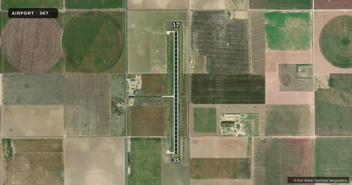
Airport sketch
Runways drawn to scale from FAA survey coordinates, rendered over satellite imagery. Not for navigation.
Approaches & charts
Services on the field
Fuel grades, oxygen, maintenance, ramp storage and lighting — as declared to the FAA by the airport operator.
Fuel & services
- Fuel
- 100LL
- Oxygen (bottled)
- Not available
- Oxygen (bulk)
- Not available
- Other services
- AGRI,INSTR,RNTL
Ramp & ground
- Transient storage
- Tie-down
- Landing fee
- No fee published
- Lighting schedule
- SEE RMK
- Beacon schedule
- SS-SR
- Beacon
- White / Green (civil land)(WG)
- Wind indicator
- Lighted
- Segmented circle
- Yes
Fuel & FBOs
Cheapest 100LL and Jet A on the field and nearby. Always confirm with the FBO before taxi.
Airport notes
Surface conditions, obstructions, local procedures, lighting outages and other notes published with each FAA cycle.
General notes
- FOR CD CTC DENVER ARTCC AT 303-651-4257.
Lighting notes
- ACTVT MIRL RWY 17/35, RWY 17 PAPI, RWY 35 PAPI - CTAF.
Fuel notes
- 100LLFOR FUEL CALL 620-375-2723/4950.
Approach & departure obstructions
- 35PAPI UNUSBL BYD 8 DEGS RIGHT OF CNTRLN.
VFR map & nearby airports
VFR sectional. Tap any ICAO chip to open that airport.
Key facts · 3K7
Answer card- ICAO
- 3K7
- Name
- MARK HOARD MEML
- Location
- LEOTI, KANSAS
- Elevation
- 3,302.9 ft MSL
- Traffic pattern altitude
- 4,302.9 ft MSL (1,000 AGL)
- Control tower
- Non-towered (use CTAF)
- Total runways
- 1
- Longest runway
- 17/35 · 5,100 ft
- Published ILS approaches
- 0
- Published frequencies
- 2
- Magnetic variation
- 5°
- Current flight rules
- VFR
- Current wind
- 260° at 5 kt
- Favored runway now
- RWY 17
Mark Hoard Meml Airport (3K7) sits in Leoti, Kansas. The field elevation is 3,302.9 ft MSL. It has one runway. Runway 17/35 is 5,100 ft long with a concrete surface. There is no control tower. CTAF and UNICOM are both 122.7.
No ILS approaches are published here. Pattern altitude is not published, so use the standard 1,000 ft AGL for light piston traffic unless the current FAA Chart Supplement says otherwise. That puts the pattern at about 4,303 ft MSL based on the listed field elevation. The runway lighting is medium intensity. Both runway ends have a PAPI. The PAPI on runway 35 is unusable beyond 8 degrees right of centerline.
This is a high-elevation Kansas field, so expect density altitude to matter on warm days. The published remarks say to use the common traffic advisory frequency. For clearance delivery, contact Denver Air Route Traffic Control Center. No on-field FBOs are listed. For fuel or current service status, call the numbers in the Chart Supplement or contact the airport operator before you go.