METAR & TAF K08
K08 does not publish a METAR.
Showing the nearest reporting station: KLAA (SOUTHEAST COLORADO RGNL) · 27.1 NM away. Conditions at K08 may differ.
METAR · KLAA
Observed 11:53Z
KLAA 271153Z AUTO 25006KT 10SM CLR 24/14 A2994 RMK AO2 SLP071 T02390144 10322 20239 53012
- Wind
- 250° @ 6 kt
- Visibility
- 10 SM
- Temp / Dew
- 24°C / 14°C
- Altimeter
- 29.94 inHg
- Clouds
- CLR
- Density alt
- 5,270 ft
- Ceiling
- Unlimited
- Rules
- VFR
Airport info & contacts
Manager on record, flight service, ARTCC, attendance schedule and pattern altitude — published by the FAA and refreshed every 28 days.
Location
- From city
- 1 NM S
- VFR sectional
- WICHITA
- ARTCC
- ZDV · DENVER
- NOTAM facility
- DEN (NOTAM-D)
Airport manager
- Name
- TOWN OF HOLLY
- Phone
- 719-537-6622
- Address
- PO BOX 458, HOLLY CO 81047
Flight service · Hours
- FSS DEN
- DENVER1-800-WX-BRIEF
- Attendance
- ON CALL
Frequencies
Tap any row to copy the frequency to your clipboard.
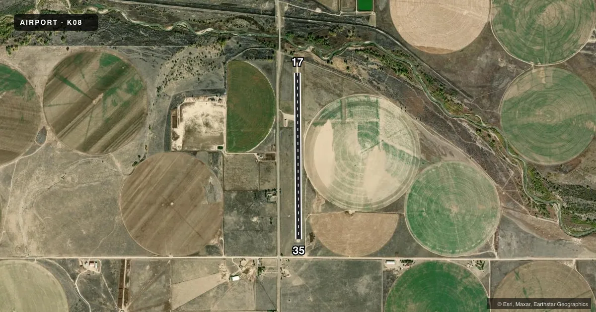
Runways & pattern
Full pagePattern entry · RWY 17
LEFT TRAFFICRunway end performance
| End | TORA | TODA | ASDA | LDA | VGSI | Approach lights | Obstruction |
|---|---|---|---|---|---|---|---|
| 17 | — | — | — | — | TRIL(3°) | — | 36', tree, 274' from thr, 114' R of cntrln, slope 7 |
| 35 | — | — | — | — | TRIL(3°) | — | 5', fence, 95' from thr, 0' R of cntrln, slope 19 |
Declared distances in feet. TORA = takeoff run available, TODA = takeoff distance, ASDA = accelerate-stop, LDA = landing distance.
Airport sketch
Runways drawn to scale from FAA survey coordinates, rendered over satellite imagery. Not for navigation.
Approaches & charts
Services on the field
Fuel grades, oxygen, maintenance, ramp storage and lighting — as declared to the FAA by the airport operator.
Fuel & services
- Fuel
- 100LL
- Oxygen (bottled)
- Not available
- Oxygen (bulk)
- Not available
- Airframe repair
- Not available
- Power plant repair
- Not available
Ramp & ground
- Transient storage
- Tie-down
- Landing fee
- No fee published
- Customs
- Not available
- Lighting schedule
- SEE RMK
- Wind indicator
- Yes
- Segmented circle
- No
Fuel & FBOs
Cheapest 100LL and Jet A on the field and nearby. Always confirm with the FBO before taxi.
Airport notes
Surface conditions, obstructions, local procedures, lighting outages and other notes published with each FAA cycle.
General notes
- RWY SOFT WHEN WET.
- RY 17 HAS +5 FT ENBANKMENT 200 FT FM RY END 0B; +10 FT ROAD 132 FT FM RY END 0B; +4 FT FENCE 100 FT FM RY THLD OB.
- RY 35 HAS +30 FT POWERLINES 575 FT NORTH OF RY END 200 FT LEFT AND RIGHT OF CENTERLINE.
- BE ALERT; INTENSIVE USAF STUDENT TRAINING IN VICINITY OF COLORADO SPRINGS & PUEBLO COLORADO.
- FOR CD CTC DENVER ARTCC AT 303-651-4257.
Lighting notes
- ACTVT NSTD LIRL RY 17/35 - CTAF.
Fuel notes
- 100LLFOR FUEL CALL TOWN OF HOLLY 719-537-6622. LAMAR DISPATCH 719-336-3995
Runway surface & condition
- 17/35NSTD LIRL EDGE LIGHTS 30 FT FM RY EDGE; LIGHTS AT VARYING HEIGHTS.
Approach & departure obstructions
- 17TRIL RY 17 & RY 35 OTS INDEFLY.
- 17RY 17/35 HAS +4 FT FENCE 120 FT FM CNTRLN ON BOTH SIDES.
Other notes
- ESTABD PRIOR TO 1959.
- 1FOR ATTNDT CALL TOWN OF HOLLY 719-537-6622. LAMAR DISPATCH 719-336-3995.
VFR map & nearby airports
VFR sectional. Tap any ICAO chip to open that airport.
Key facts · K08
Answer card- ICAO
- K08
- Name
- HOLLY
- Location
- HOLLY, COLORADO
- Elevation
- 3,399 ft MSL
- Traffic pattern altitude
- 4,399 ft MSL (1,000 AGL)
- Control tower
- Non-towered (use CTAF)
- Total runways
- 1
- Longest runway
- 17/35 · 4,140 ft
- Published ILS approaches
- 0
- Published frequencies
- 2
- Magnetic variation
- 10°
- Current flight rules
- VFR
- Current wind
- 250° at 6 kt
- Favored runway now
- RWY 17
Holly Airport (K08) sits in Holly, Colorado. The field elevation is 3,399 ft MSL. It has one runway, 17/35, which is 4,140 ft long and surfaced gravel-dirt. There is no control tower. CTAF and UNICOM are both 122.8. No ILS approaches are published.
The pattern altitude is not published. Use the standard 1,000 ft AGL pattern unless local guidance says otherwise. That puts the light piston pattern at 4,399 ft MSL. The runway lighting is nonstandard low intensity and is controlled by CTAF. The published remarks also note that runway 17/35 has surface obstruction lights that remain in place. Fences are near the runway. Powerlines are off the runway 35 end. Runway 17 also has nearby embankment, road and fence obstructions close to the end.
There are no on-field FBOs listed. For fuel and attendant service, call the Town of Holly or Lamar Dispatch before arrival. The remarks also say the runway can be soft when wet. That matters here. Plan for a careful surface check and use current field conditions before committing. Clearance delivery is handled through Denver ARTCC. The airport sits in open country, so watch density altitude, wind and surface condition closely on a warm day.