METAR & TAF 9V7
9V7 does not publish a METAR.
Showing the nearest reporting station: KLAA (SOUTHEAST COLORADO RGNL) · 25.0 NM away. Conditions at 9V7 may differ.
METAR · KLAA
Observed 10:53Z
KLAA 271053Z AUTO 28012KT 10SM CLR 26/14 A2993 RMK AO2 SLP064 T02560144
- Wind
- 280° @ 12 kt
- Visibility
- 10 SM
- Temp / Dew
- 26°C / 14°C
- Altimeter
- 29.93 inHg
- Clouds
- CLR
- Density alt
- 6,571 ft
- Ceiling
- Unlimited
- Rules
- VFR
Airport info & contacts
Manager on record, flight service, ARTCC, attendance schedule and pattern altitude — published by the FAA and refreshed every 28 days.
Location
- From city
- 1 NM W
- VFR sectional
- WICHITA
- ARTCC
- ZDV · DENVER
- NOTAM facility
- DEN (NOTAM-D)
Airport manager
- Name
- TRENT RITTGERS
- Phone
- 719-931-3761
- Address
- CITY HALL BOX 8, EADS CO 81036
Flight service · Hours
- FSS DEN
- DENVER1-800-WX-BRIEF
- Attendance
- Unattended
Frequencies
Tap any row to copy the frequency to your clipboard.
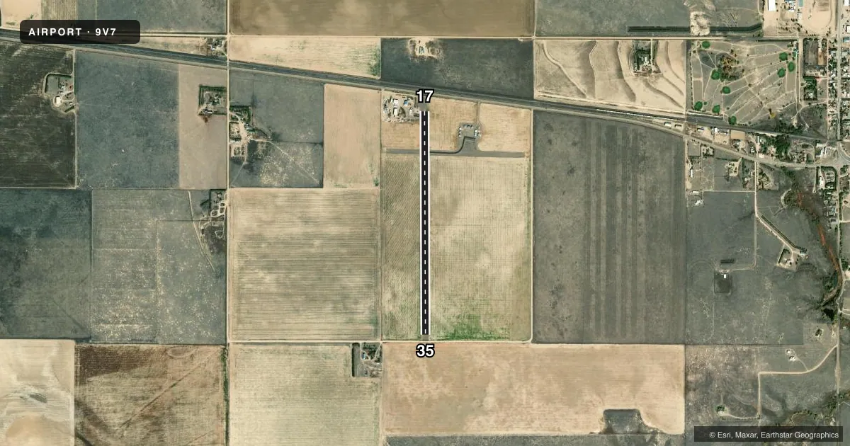
Runways & pattern
Full pagePattern entry · RWY 35
LEFT TRAFFICRunway end performance
| End | TORA | TODA | ASDA | LDA | VGSI | Approach lights | Obstruction |
|---|---|---|---|---|---|---|---|
| 17 | — | — | — | — | — | — | 18', road, 400' from thr, 0' R of cntrln, slope 11 |
| 35 | — | — | — | — | — | — | 16', road, 204' from thr, 0' R of cntrln, slope 0 |
Declared distances in feet. TORA = takeoff run available, TODA = takeoff distance, ASDA = accelerate-stop, LDA = landing distance.
Airport sketch
Runways drawn to scale from FAA survey coordinates, rendered over satellite imagery. Not for navigation.
Approaches & charts
Services on the field
Fuel grades, oxygen, maintenance, ramp storage and lighting — as declared to the FAA by the airport operator.
Fuel & services
- Fuel
- Not available
- Oxygen (bottled)
- Not available
- Oxygen (bulk)
- Not available
- Airframe repair
- Not available
- Power plant repair
- Not available
- Other services
- AGRI
Ramp & ground
- Transient storage
- Tie-down
- Landing fee
- No fee published
- Customs
- Not available
- Lighting schedule
- SS-SR
- Wind indicator
- Yes
- Segmented circle
- No
Fuel & FBOs
Cheapest 100LL and Jet A on the field and nearby. Always confirm with the FBO before taxi.
Airport notes
Surface conditions, obstructions, local procedures, lighting outages and other notes published with each FAA cycle.
General notes
- APRON AREA IS ASPH.
- UNCONTROLLED VEHICLE ACCESS TO OPNS AREA & RYS.
- RWY 17 HAS +25 FT RAILROAD 530 FT FM THLD CNTRLN.
- BE ALERT; INTSV USAF STUDENT TRNG INVOF COLORADO SPRINGS & PUEBLO COLORADO.
- RWY 17 +25 FT BLDGS 300 FT RIGHT OF CNTRLN 108 FT FM RWY END.
- FOR CD CTC DENVER ARTCC AT 303-651-4257.
- TWY AND RWY HAVE NO MRKGS.
Approach & departure obstructions
- 17RWY 17 +10 FT ROAD 40 FT RIGHT OF CNTRLN 5 FT FM RWY END. LRG SPOOLS LCTD 190 FT FM RWY THLD 25 FT RIGHT OF CNTRLN.
- 17PUB RD APRX 204 FT FM RWY 35 EXT CNTRLN, 16 FT ABV RWY END.
Other notes
- ESTABD PRIOR TO 1953, REACTIVATED 1963.
- MANAGERAFT HRS MGR PHONE NR 719-688-7294.
- 17/35CNTRLN HAS A LRG CRACK FULL LEN OF RWY.
VFR map & nearby airports
VFR sectional. Tap any ICAO chip to open that airport.
Key facts · 9V7
Answer card- ICAO
- 9V7
- Name
- EADS MUNI
- Location
- EADS, COLORADO
- Elevation
- 4,245 ft MSL
- Traffic pattern altitude
- 5,245 ft MSL (1,000 AGL)
- Control tower
- Non-towered (use CTAF)
- Total runways
- 1
- Longest runway
- 17/35 · 3,860 ft
- Published ILS approaches
- 0
- Published frequencies
- 1
- Magnetic variation
- 10°
- Current flight rules
- VFR
- Current wind
- 280° at 12 kt
- Favored runway now
- RWY 35
Eads Muni Airport (9V7) sits in Eads, Colorado. The field elevation is 4,245 ft MSL. It has one runway. Runway 17/35 is 3,860 ft long with an asphalt surface. There is no control tower. CTAF is 122.9. No ILS approaches are published here. The pattern altitude is not published, so use the standard 1,000 ft AGL for light piston traffic unless the current FAA Chart Supplement says otherwise.
There are no on-field FBOs listed in the facts. Contact the airport operator directly before arrival. You can also call the field on CTAF for current fuel and service availability. Published remarks note after-hours manager contact at 719-688-7294. They also flag uncontrolled vehicle access to the operations area and runways. Taxiways and runways have no markings. That matters here because the field is simple and the surface can be easy to misread from the air.
This is a high-elevation airport in eastern Colorado. Expect density altitude to matter on warm days. The remarks also call out intensive U.S. Air Force student training in the Colorado Springs and Pueblo area. Keep a sharp lookout in the region. Runway 17 has several nearby obstructions, including a road, buildings, railroad and large spools. Runway 35 also has a public road near the extended centerline. Check the current FAA Chart Supplement before you go.