METAR & TAF KLHX
Current METAR
Observed 06:53Z
KLHX 270653Z AUTO 30014KT 10SM CLR 27/14 A2998 RMK AO2 SLP070 T02670144 404220217
- Wind
- 300° @ 14 kt
- Visibility
- 10 SM
- Temp / Dew
- 27°C / 14°C
- Altimeter
- 29.98 inHg
- Clouds
- CLR
- Density alt
- 6,609 ft
- Ceiling
- Unlimited
- Rules
- VFR
Airport info & contacts
Manager on record, flight service, ARTCC, attendance schedule and pattern altitude — published by the FAA and refreshed every 28 days.
Location
- From city
- 3 NM N
- VFR sectional
- WICHITA
- ARTCC
- ZDV · DENVER
- NOTAM facility
- LHX (NOTAM-D)
Airport manager
- Name
- BROCK HINKHOUSE
- Phone
- 719-363-1253
- Address
- P O BOX 489, LA JUNTA CO 81050
Flight service · Hours
- FSS DEN
- DENVER1-800-WX-BRIEF
- Attendance
- 0700-1600
Frequencies
Tap any row to copy the frequency to your clipboard.
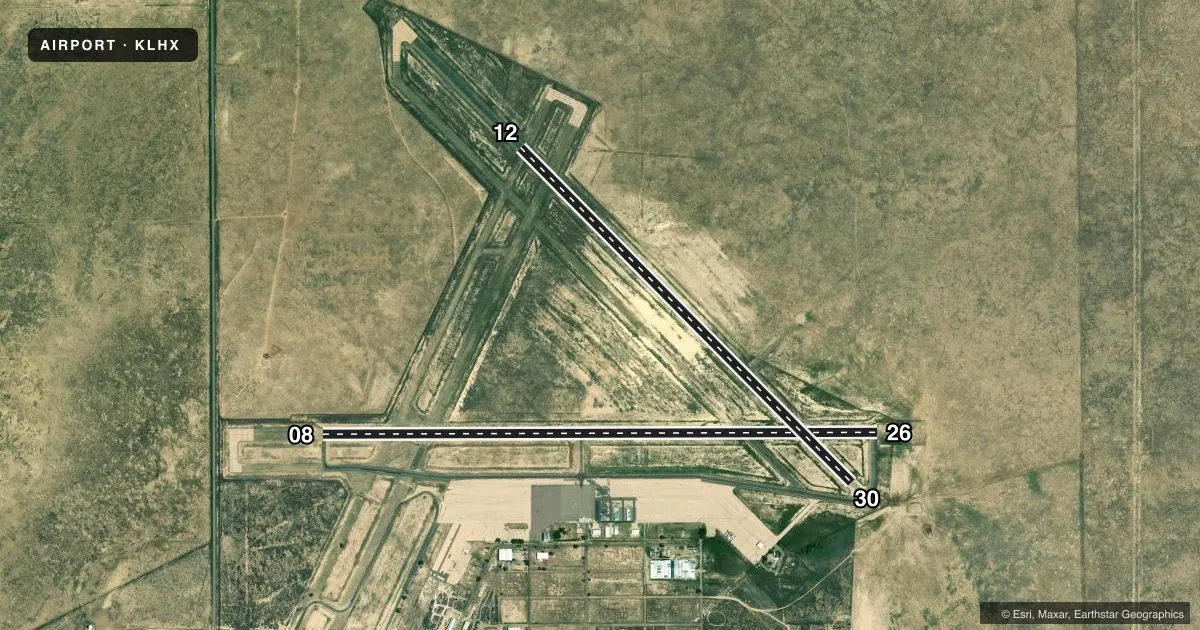
Runways & pattern
Full pagePattern entry · RWY 30
LEFT TRAFFIC| Runway | Heading (°M) | Length | Surface | Traffic |
|---|---|---|---|---|
| 08/26 | 81° / 261° | 6,849 ft | ASPH | Standard L |
| 12/30Favored | 126° / 306° | 5,803 ft | ASPH-CONC | Standard L |
Runway end performance
| End | TORA | TODA | ASDA | LDA | VGSI | Approach lights | Obstruction |
|---|---|---|---|---|---|---|---|
| 08 | — | — | — | — | PAPI 2-box left(3°) | — | 28', road, 1351' from thr, 8' R of cntrln, slope 41 |
| 26 | — | — | — | — | PAPI 2-box left(3°) | — | — |
Declared distances in feet. TORA = takeoff run available, TODA = takeoff distance, ASDA = accelerate-stop, LDA = landing distance.
Airport sketch
Runways drawn to scale from FAA survey coordinates, rendered over satellite imagery. Not for navigation.
Approaches & charts
Services on the field
Fuel grades, oxygen, maintenance, ramp storage and lighting — as declared to the FAA by the airport operator.
Fuel & services
- Fuel
- 100LLA
- Oxygen (bottled)
- Not available
- Other services
- AGRI,AMB,INSTR
Ramp & ground
- Transient storage
- Tie-down
- Hangar
- Landing fee
- No fee published
- Customs
- Not available
- Lighting schedule
- SEE RMK
- Beacon schedule
- SS-SR
- Beacon
- White / Green (civil land)(WG)
- Wind indicator
- Lighted
- Segmented circle
- Yes
Fuel & FBOs
Cheapest 100LL and Jet A on the field and nearby. Always confirm with the FBO before taxi.
Airport notes
Surface conditions, obstructions, local procedures, lighting outages and other notes published with each FAA cycle.
General notes
- ANTELOPE ON & INVOF ARPT.
- HVY AGRICULTURAL OPNS DURG SUMMER MONTHS.
- RWY 12/30 HAS LOOSE ASPH MTRL IN PRIM SFC WEST SIDE OF RWY FULL LENGTH.
- RWY 12/30 EDGE UNDEFINED.
- BE ALERT; INTENSIVE USAF STUDENT TRNG INVOF COLORADO SPRINGS & PUEBLO COLORADO.
- SELF SERVE JET-A NOT AVAIL.
- FOR CD CTC DENVER ARTCC AT 303-651-4257.
Lighting notes
- ACTVT REIL RWY 08 & 26; PAPI RWY 08 & 26; MIRL RWY 08/26 - CTAF.
Other notes
- THIS AIRPORT HAS BEEN SURVEYED BY THE NATIONAL GEODETIC SURVEY.
- MANAGERALT CTC FBO 719-384-8407.
- 12/30RWY SFC RAVELING WITH FOD POTENTIAL.
VFR map & nearby airports
VFR sectional. Tap any ICAO chip to open that airport.
Key facts · KLHX
Answer card- ICAO
- KLHX
- Name
- LA JUNTA MUNI
- Location
- LA JUNTA, COLORADO
- Elevation
- 4,228.6 ft MSL
- Traffic pattern altitude
- 5,228.6 ft MSL (1,000 AGL)
- Control tower
- Non-towered (use CTAF)
- Total runways
- 2
- Longest runway
- 08/26 · 6,849 ft
- Published ILS approaches
- 0
- Published frequencies
- 2
- Magnetic variation
- 9°
- Current flight rules
- VFR
- Current wind
- 300° at 14 kt
- Favored runway now
- RWY 30
La Junta Muni sits in La Junta, Colorado. Field elevation is 4,228.6 ft MSL. The airport has two runways. The longest is runway 08/26 at 6,849 ft. There is no control tower. CTAF and UNICOM are both 123.0. No ILS approaches are published, so plan with the current chart and weather in mind.
Pattern altitude is not published. Use 1,000 ft AGL for light piston operations unless the current FAA Chart Supplement says otherwise. La Junta Municipal Airport is the on-field FBO. It carries 100LL and Jet A Prist. Self-serve Jet-A is not available. The published remarks also note loose asphalt and foreign object debris risk on runway 12/30. The west side of that runway has loose material along the full length. A careful taxi and takeoff scan makes sense.
This is a high-elevation field, so performance planning matters. Summer agricultural traffic can be heavy. The area also sees United States Air Force student training in the broader region around Colorado Springs and Pueblo. Antelope may be on or near the airport. Runway 08/26 has runway end identifier lights, PAPI and medium intensity runway lighting. Use CTAF for the lights. For clearance delivery, contact Denver ARTCC.