METAR & TAF 7V9
7V9 does not publish a METAR.
Showing the nearest reporting station: KLHX (LA JUNTA MUNI) · 12.8 NM away. Conditions at 7V9 may differ.
METAR · KLHX
Observed 03:53Z
KLHX 270353Z AUTO 05014G19KT 10SM CLR 31/11 A2998 RMK AO2 SLP070 T03110111
- Wind
- 050° @ 14G19 kt
- Visibility
- 10 SM
- Temp / Dew
- 31°C / 11°C
- Altimeter
- 29.98 inHg
- Clouds
- CLR
- Density alt
- 6,700 ft
- Ceiling
- Unlimited
- Rules
- VFR
Airport info & contacts
Manager on record, flight service, ARTCC, attendance schedule and pattern altitude — published by the FAA and refreshed every 28 days.
Location
- From city
- 1 NM S
- VFR sectional
- WICHITA
- ARTCC
- ZDV · DENVER
- NOTAM facility
- DEN (NOTAM-D)
Airport manager
- Name
- G DOUGLAS BANKERT
- Phone
- 719-662-1225
- Address
- 725 BENT AVE, PO BOX 350, LAS ANIMAS CO 81054
Flight service · Hours
- FSS DEN
- DENVER1-800-WX-BRIEF
Frequencies
Tap any row to copy the frequency to your clipboard.
Runways & pattern
Full pagePattern entry · RWY 08
LEFT TRAFFICRunway end performance
| End | TORA | TODA | ASDA | LDA | VGSI | Approach lights | Obstruction |
|---|---|---|---|---|---|---|---|
| 08 | — | — | — | — | — | — | 22', tree, 357' from thr, 104' R of cntrln, slope 7 |
| 26 | — | — | — | — | — | — | 16', road, 500' from thr, 0' R of cntrln, slope 18 |
Declared distances in feet. TORA = takeoff run available, TODA = takeoff distance, ASDA = accelerate-stop, LDA = landing distance.
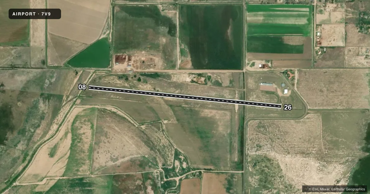
Airport sketch
Runways drawn to scale from FAA survey coordinates, rendered over satellite imagery. Not for navigation.
Approaches & charts
Services on the field
Fuel grades, oxygen, maintenance, ramp storage and lighting — as declared to the FAA by the airport operator.
Fuel & services
- Fuel
- Not available
- Oxygen (bottled)
- Not available
- Oxygen (bulk)
- Not available
- Airframe repair
- Not available
- Power plant repair
- Not available
Ramp & ground
- Transient storage
- Tie-down
- Landing fee
- No fee published
- Customs
- Not available
- Lighting schedule
- SEE RMK
- Wind indicator
- Lighted
- Segmented circle
- No
Fuel & FBOs
Cheapest 100LL and Jet A on the field and nearby. Always confirm with the FBO before taxi.
Airport notes
Surface conditions, obstructions, local procedures, lighting outages and other notes published with each FAA cycle.
General notes
- RY 26 HAS -4 FT DITCH 30 FT FM RY END ON BOTH SIDES
- RY 26 HAS +30 FT POLES 105 FT FM THLD 210 FT L OF EXTNDD RY CNTRLN.
- RY 08 HAS +4 FT FENCE 275 FT FM THLD OB; HAS -3 FT DITCH 35 FT FM RY END ON BOTH SIDES.
- BE ALERT; INTENSIVE USAF STUDENT TRAINING IN VICINITY OF COLORADO SPRINGS & PUEBLO COLORADO.
- FOR CD CTC DENVER ARTCC AT 303-651-4257.
- RWY 8/26 HAS TREES GROWING 50+ FT FM EITHER SIDE OF RWY CNTRLN.
- RWY 08 & 26 REILS OTS.
Lighting notes
- ACTVT HIRL RY 08/26 - CTAF. MED INTST 5 CLICKS, HIGH INTST 7 CLICKS.
Approach & departure obstructions
- 08RWY 08 & 26 REILS OTS.
- 26RWY 08 & 26 REILS OTS.
- 08RWY 08 THLD MARKINGS WORN & UNRDBL.
- 26RY 8/26 NUMBERS SMALLER THAN STANDARD.
VFR map & nearby airports
VFR sectional. Tap any ICAO chip to open that airport.
Key facts · 7V9
Answer card- ICAO
- 7V9
- Name
- CITY OF LAS ANIMAS - BENT COUNTY
- Location
- LAS ANIMAS, COLORADO
- Elevation
- 3,915 ft MSL
- Traffic pattern altitude
- 4,915 ft MSL (1,000 AGL)
- Control tower
- Non-towered (use CTAF)
- Total runways
- 1
- Longest runway
- 08/26 · 3,870 ft
- Published ILS approaches
- 0
- Published frequencies
- 1
- Magnetic variation
- 10°
- Current flight rules
- VFR
- Current wind
- 050° at 14 kt
- Favored runway now
- RWY 08
City of Las Animas - Bent County Airport (7V9) sits in Las Animas, Colorado. Field elevation is 3,915 ft MSL. The airport has one runway, 08/26, which is 3,870 ft long. There is no control tower. CTAF is 122.9. No ILS approaches are published here.
Pattern altitude is not published. Use 1,000 ft AGL for light piston operations unless the current Chart Supplement says otherwise. The published remarks matter here. Runway 26 has poles near the departure end and trees close to both sides of the runway. Runway 08 has a fence near the threshold, plus a ditch near the runway end. Runway end identifier lights are out of service on both ends. Runway 08 threshold markings are worn and unreadable. The runway numbers are smaller than standard.
This is an uncontrolled field in a high-elevation part of Colorado. Expect density altitude to be a real factor on warm days. Also note the published warning about intensive U.S. Air Force student training in the Colorado Springs and Pueblo area. For clearance delivery, contact Denver ARTCC at 303-651-4257. If you need any current operational detail beyond what is published here, check the current FAA Chart Supplement or call the airport operator directly.