METAR & TAF 3K3
Current METAR
Observed 05:55Z
K3K3 270555Z AUTO 19013G18KT 10SM CLR 32/13 A2991 RMK AO2 10433 20321
- Wind
- 190° @ 13G18 kt
- Visibility
- 10 SM
- Temp / Dew
- 32°C / 13°C
- Altimeter
- 29.91 inHg
- Clouds
- CLR
- Density alt
- 6,177 ft
- Ceiling
- Unlimited
- Rules
- VFR
Airport info & contacts
Manager on record, flight service, ARTCC, attendance schedule and pattern altitude — published by the FAA and refreshed every 28 days.
Location
- From city
- 1 NM N
- VFR sectional
- WICHITA
- ARTCC
- ZDV · DENVER
- NOTAM facility
- ICT (NOTAM-D)
Airport manager
- Name
- STEVE PHILLIPS
- Phone
- 620-384-5435
- Address
- BOX 1136, SYRACUSE KS 67878
Flight service · Hours
- FSS ICT
- WICHITA1-800-WX-BRIEF
- Attendance
- INTMNT
Frequencies
Tap any row to copy the frequency to your clipboard.
Runways & pattern
Full pagePattern entry · RWY 18
RIGHT TRAFFIC| Runway | Heading (°M) | Length | Surface | Traffic |
|---|---|---|---|---|
| 18/36Favored | 183° / 3° | 4,600 ft | CONC | 18 R |
| 13/31 | 128° / 308° | 3,000 ft | ASPH | 31 R |
Runway end performance
| End | TORA | TODA | ASDA | LDA | VGSI | Approach lights | Obstruction |
|---|---|---|---|---|---|---|---|
| 18 | — | — | — | — | PAPI 4-box right(3°) | — | 55', pline, 1327' from thr, 0' R of cntrln, slope 20 |
| 36 | — | — | — | — | PAPI 4-box left(3.2°) | — | 70', tower, 1870' from thr, 350' R of cntrln, slope 23 |
| 13 | — | — | — | — | — | — | 13', road, 201' from thr, 120' R of cntrln, slope 0 |
| 31 | — | — | — | — | — | — | 27', tree, 201' from thr, 87' R of cntrln, slope 0 |
Declared distances in feet. TORA = takeoff run available, TODA = takeoff distance, ASDA = accelerate-stop, LDA = landing distance.
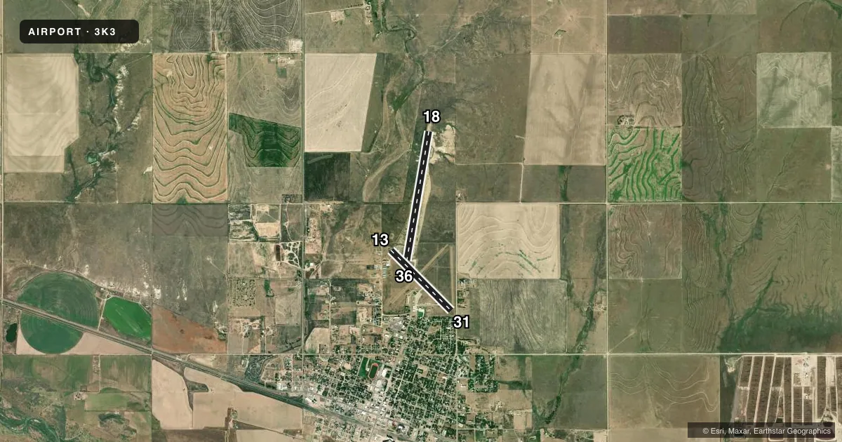
Airport sketch
Runways drawn to scale from FAA survey coordinates, rendered over satellite imagery. Not for navigation.
Approaches & charts
Services on the field
Fuel grades, oxygen, maintenance, ramp storage and lighting — as declared to the FAA by the airport operator.
Fuel & services
- Fuel
- 100LL
- Oxygen (bottled)
- Not available
- Oxygen (bulk)
- Not available
- Airframe repair
- Minor
- Power plant repair
- Minor
- Other services
- AGRI
Ramp & ground
- Transient storage
- Tie-down
- Hangar
- Landing fee
- No fee published
- Customs
- Not available
- Lighting schedule
- SEE RMK
- Beacon schedule
- SS-SR
- Beacon
- White / Green (civil land)(WG)
- Wind indicator
- Lighted
- Segmented circle
- No
Fuel & FBOs
Cheapest 100LL and Jet A on the field and nearby. Always confirm with the FBO before taxi.
Airport notes
Surface conditions, obstructions, local procedures, lighting outages and other notes published with each FAA cycle.
General notes
- PUBLIC PHONE 620-384-5835.
- FOR CD CTC DENVER ARTCC AT 303-651-4257.
Lighting notes
- DUSK-DAWN. ACTVT PAPI RWY 18 & 36, MIRL RWY 13/31, RWY 18/36 - CTAF.
Approach & departure obstructions
- 3127 FT TREE, 190 FT DSTC, 87 FT L; 15 ROAD, 199 FT DSTC 91 FT R.
- 13CONTROLLING OBSTN EXCEEDS A 45 DEG SLP.
- 31OBSTN CLNC SLOPE 21:1 TO DTHR OVR 27 FT TREE, 575 FT DSTC, 87 FT L.
Other notes
- 1FOR ATTENDANT AFT HRS CALL 620-384-5835
VFR map & nearby airports
VFR sectional. Tap any ICAO chip to open that airport.
Key facts · 3K3
Answer card- ICAO
- 3K3
- Name
- SYRACUSE-HAMILTON COUNTY MUNI
- Location
- SYRACUSE, KANSAS
- Elevation
- 3,326.1 ft MSL
- Traffic pattern altitude
- 4,326.1 ft MSL (1,000 AGL)
- Control tower
- Non-towered (use CTAF)
- Total runways
- 2
- Longest runway
- 18/36 · 4,600 ft
- Published ILS approaches
- 0
- Published frequencies
- 2
- Magnetic variation
- 7°
- Current flight rules
- VFR
- Current wind
- 190° at 13 kt
- Favored runway now
- RWY 18
Syracuse-Hamilton County Muni sits in Syracuse, Kansas. Field elevation is 3,326.1 ft MSL. The airport has two runways. The longest is runway 18/36 at 4,600 ft. Runway 13/31 is 3,000 ft. There is no control tower. CTAF and UNICOM are both 122.8.
No ILS approaches are published here. The pattern altitude is not published, so use standard 1,000 ft AGL for light piston ops unless the current Chart Supplement says otherwise. Crosswind Flight Services is on the field. It carries AVGAS 100LL and Jet A. Call the published number for current service or after-hours help.
This is a higher-elevation Kansas field, so performance planning matters. Density altitude can climb fast in warm weather. The published remarks also call out obstructions near runway 13 and runway 31. Runway 18 and 36 have PAPI. Runways 13 and 31 have medium intensity runway lights. Lighting is available from dusk to dawn. If you need clearance delivery, contact Denver ARTCC. Check the current Chart Supplement for any noise or local operating notes before you go in.