METAR & TAF 5K2
5K2 does not publish a METAR.
Showing the nearest reporting station: KTQK (SCOTT CITY MUNI) · 40.7 NM away. Conditions at 5K2 may differ.
METAR · KTQK
Observed 07:35Z
KTQK 270735Z AUTO 21006KT 10SM CLR 23/16 A2990 RMK AO2 T02310158
- Wind
- 210° @ 6 kt
- Visibility
- 10 SM
- Temp / Dew
- 23°C / 16°C
- Altimeter
- 29.90 inHg
- Clouds
- CLR
- Density alt
- 5,461 ft
- Ceiling
- Unlimited
- Rules
- VFR
Airport info & contacts
Manager on record, flight service, ARTCC, attendance schedule and pattern altitude — published by the FAA and refreshed every 28 days.
Location
- From city
- 1 NM S
- VFR sectional
- WICHITA
- ARTCC
- ZDV · DENVER
- NOTAM facility
- ICT (NOTAM-D)
Airport manager
- Name
- STEPHANIE REICHERT
- Phone
- 620-376-4278
- Address
- 508 BROADWAY, PO BOX 577, TRIBUNE KS 67879
Flight service · Hours
- FSS ICT
- WICHITA1-800-WX-BRIEF
- Attendance
- Unattended
Frequencies
Tap any row to copy the frequency to your clipboard.
Runways & pattern
Full pagePattern entry · RWY 17
LEFT TRAFFICRunway end performance
| End | TORA | TODA | ASDA | LDA | VGSI | Approach lights | Obstruction |
|---|---|---|---|---|---|---|---|
| 17 | — | — | — | — | — | — | 10', road, 522' from thr, 300' R of cntrln, slope 32 |
| 35 | — | — | — | — | PAPI 2-box left(3°) | — | 55', pline, 2835' from thr, 650' R of cntrln, slope 47 |
Declared distances in feet. TORA = takeoff run available, TODA = takeoff distance, ASDA = accelerate-stop, LDA = landing distance.
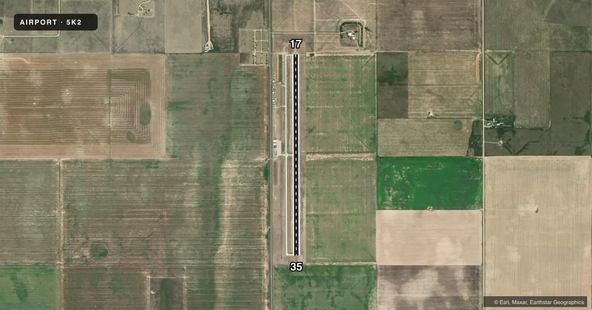
Airport sketch
Runways drawn to scale from FAA survey coordinates, rendered over satellite imagery. Not for navigation.
Approaches & charts
Services on the field
Fuel grades, oxygen, maintenance, ramp storage and lighting — as declared to the FAA by the airport operator.
Fuel & services
- Fuel
- 100LL
- Oxygen (bottled)
- Not available
- Oxygen (bulk)
- Not available
- Other services
- AGRI
Ramp & ground
- Transient storage
- Tie-down
- Landing fee
- No fee published
- Lighting schedule
- SEE RMK
- Beacon schedule
- SS-SR
- Beacon
- White / Green (civil land)(WG)
- Wind indicator
- Lighted
- Segmented circle
- No
Fuel & FBOs
Cheapest 100LL and Jet A on the field and nearby. Always confirm with the FBO before taxi.
Airport notes
Surface conditions, obstructions, local procedures, lighting outages and other notes published with each FAA cycle.
General notes
- PUB TELEPHONE AVBL 24 HRS 620-376-2285.
- FOR CD CTC DENVER ARTCC AT 303-651-4257.
Lighting notes
- ACTVT MIRLS RWY 17/35, & PAPI RWY 35 - CTAF
Fuel notes
- 100LLFOR FUEL CALL 620-376-4299.
Other notes
- PRVDD APCH SLOPES ARE CLEARED & MAINT FOR A 20:1 GLIDE SLOPE.
- MANAGER620-376-8367 FOR REFUELING.
- OWNERADDRESS QUESTIONS TO: PO BOX 577 508 BROADWAY TRIBUNE, KS 67879 CITYOFTRIBUNE@WBSNET.ORG
VFR map & nearby airports
VFR sectional. Tap any ICAO chip to open that airport.
Key facts · 5K2
Answer card- ICAO
- 5K2
- Name
- TRIBUNE MUNI
- Location
- TRIBUNE, KANSAS
- Elevation
- 3,609.9 ft MSL
- Traffic pattern altitude
- 4,609.9 ft MSL (1,000 AGL)
- Control tower
- Non-towered (use CTAF)
- Total runways
- 1
- Longest runway
- 17/35 · 5,007 ft
- Published ILS approaches
- 0
- Published frequencies
- 2
- Magnetic variation
- 7°
- Current flight rules
- VFR
- Current wind
- 210° at 6 kt
- Favored runway now
- RWY 17
Tribune Muni sits in Tribune, Kansas. The field elevation is 3,609.9 ft MSL, so expect high-density-altitude performance to matter on warm days. The airport has one runway. Runway 17/35 is 5,007 ft of concrete, which is the longest runway on the field. There is no control tower. CTAF and UNICOM are both 122.8.
No ILS approaches are published here. Pattern altitude is not published in the facts, so use the current Chart Supplement and standard local traffic practice before you go. The published remarks also note runway lights on 17/35 and the PAPI for runway 35 are activated on CTAF. Approach slopes are expected to be kept clear on a 20 to 1 glide slope. That matters if you are arriving low over nearby obstacles or terrain.
Tribune Municipal Airport is the on-field FBO listed in the facts. It carries 100LL. For fuel or refueling, call the numbers in the Chart Supplement or the airport directly before arrival. If you need clearance delivery, contact Denver ARTCC. For a first trip, plan for an unattended field. Confirm lighting needs before night arrival. Verify the current traffic pattern and any local procedures with the airport operator.