METAR & TAF KJHN
Current METAR
Observed 13:15Z
KJHN 271315Z AUTO 21010KT 7SM -DZ CLR 26/13 A2993 RMK AO2
- Wind
- 210° @ 10 kt
- Visibility
- 7 SM
- Temp / Dew
- 26°C / 13°C
- Altimeter
- 29.93 inHg
- Clouds
- CLR
- Density alt
- 5,431 ft
- Ceiling
- Unlimited
- Rules
- VFR
Airport info & contacts
Manager on record, flight service, ARTCC, attendance schedule and pattern altitude — published by the FAA and refreshed every 28 days.
Location
- From city
- 2 NM NE
- VFR sectional
- WICHITA
- ARTCC
- ZKC · KANSAS CITY
- NOTAM facility
- ICT (NOTAM-D)
Airport manager
- Name
- JACOB NIX
- Phone
- 580-330-0589
- Address
- 105 N. AIRPORT RD, JOHNSON CITY KS 67855
Flight service · Hours
- FSS ICT
- WICHITA1-800-WX-BRIEF
- Attendance
- 0800-1800
Frequencies
Tap any row to copy the frequency to your clipboard.
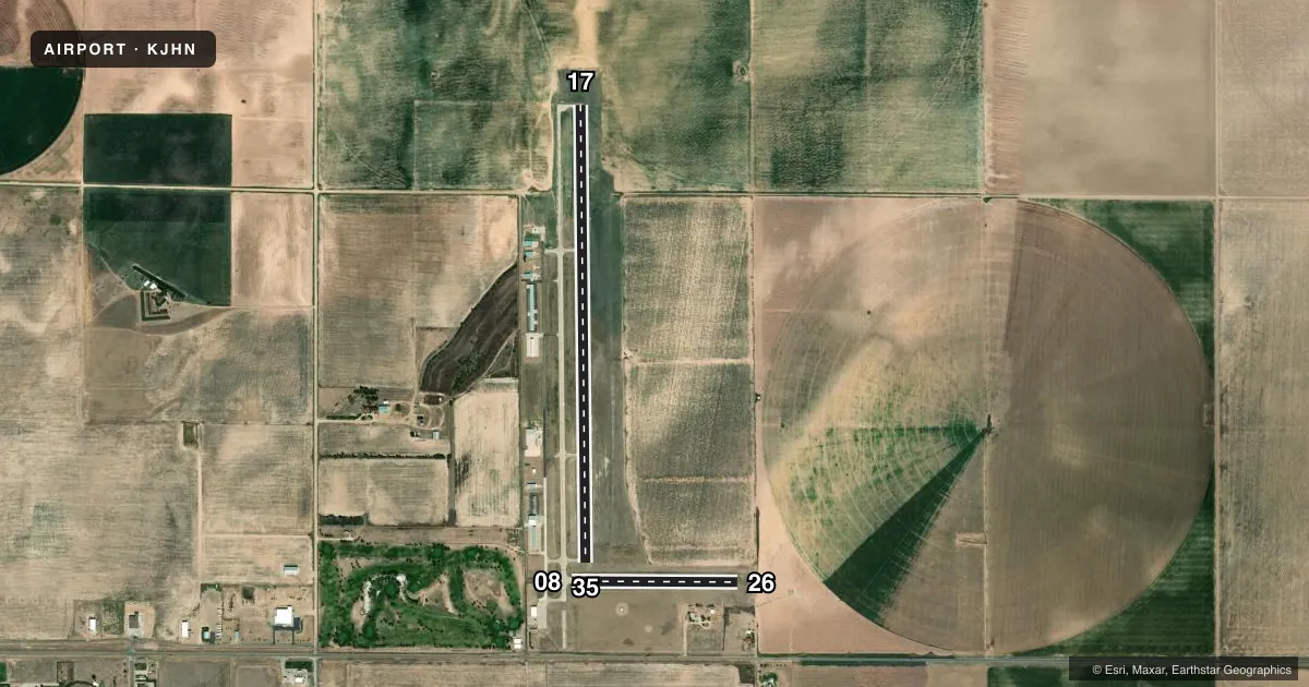
Runways & pattern
Full pagePattern entry · RWY 17
LEFT TRAFFIC| Runway | Heading (°M) | Length | Surface | Traffic |
|---|---|---|---|---|
| 17/35Favored | 172° / 352° | 5,200 ft | CONC | Standard L |
| 08/26 | 83° / 263° | 1,889 ft | ASPH | Standard L |
Runway end performance
| End | TORA | TODA | ASDA | LDA | VGSI | Approach lights | Obstruction |
|---|---|---|---|---|---|---|---|
| 17 | — | — | — | — | PAPI 4-box left(3°) | — | — |
| 35 | — | — | — | — | PAPI 4-box left(3°) | — | — |
Declared distances in feet. TORA = takeoff run available, TODA = takeoff distance, ASDA = accelerate-stop, LDA = landing distance.
Airport sketch
Runways drawn to scale from FAA survey coordinates, rendered over satellite imagery. Not for navigation.
Approaches & charts
Services on the field
Fuel grades, oxygen, maintenance, ramp storage and lighting — as declared to the FAA by the airport operator.
Fuel & services
- Fuel
- 100LLA
- Oxygen (bottled)
- Not available
- Oxygen (bulk)
- High pressure
- Airframe repair
- Major
- Power plant repair
- Major
- Other services
- AFRT,AGRI,INSTR,RNTL
Ramp & ground
- Transient storage
- Tie-down
- Hangar
- Landing fee
- No fee published
- Customs
- Not available
- Lighting schedule
- SEE RMK
- Beacon schedule
- SS-SR
- Beacon
- White / Green (civil land)(WG)
- Wind indicator
- Lighted
- Segmented circle
- Yes
Fuel & FBOs
Cheapest 100LL and Jet A on the field and nearby. Always confirm with the FBO before taxi.
Airport notes
Surface conditions, obstructions, local procedures, lighting outages and other notes published with each FAA cycle.
General notes
- PUB TELEPHONE AVBL 24 HRS 620-492-2414.
- FOR CD CTC KANSAS CITY ARTCC AT 913-254-8508.
Lighting notes
- MIRL RWY 17/35 PRESET ON LOW INTST DUSK-2200; TO INCR INTST AND ACTVT AFT 2200 - CTAF.
Other notes
- 08/26SURFACE CRACKING.
VFR map & nearby airports
VFR sectional. Tap any ICAO chip to open that airport.
Key facts · KJHN
Answer card- ICAO
- KJHN
- Name
- STANTON COUNTY MUNI
- Location
- JOHNSON CITY, KANSAS
- Elevation
- 3,325.3 ft MSL
- Traffic pattern altitude
- 4,325.3 ft MSL (1,000 AGL)
- Control tower
- Non-towered (use CTAF)
- Total runways
- 2
- Longest runway
- 17/35 · 5,200 ft
- Published ILS approaches
- 0
- Published frequencies
- 2
- Magnetic variation
- 7°
- Current flight rules
- VFR
- Current wind
- 210° at 10 kt
- Favored runway now
- RWY 17
Stanton County Muni sits in Johnson City, Kansas. Field elevation is 3,325.3 ft MSL. The airport has two runways. The longest is 17/35 at 5,200 ft. Runway 08/26 is 1,889 ft. There is no control tower. CTAF and UNICOM are both 122.8.
No ILS approaches are published here. Pattern altitude is not published, so use the standard 1,000 ft AGL for light piston operations unless the current Chart Supplement says otherwise. Bear Creek Aviation is on the field. It carries 100LL and Jet A. The published remarks also note surface cracking on runway 08/26. That is worth checking during your preflight planning. Check it again after landing if you plan to use that strip.
Runway 17/35 has medium intensity lights. They are preset on low intensity from dusk to 2200. After 2200, use CTAF to increase intensity and activate the lights. For clearance delivery, contact Kansas City ARTCC at the published number before departure. This is a high-elevation field at 3,325 ft MSL, so density altitude can matter on warm days. Expect longer takeoff rolls and reduced climb performance. Verify current runway condition, lighting use and any local procedures with the airport operator or the FBO directly by phone before you go.